- Will Weaver's Weather & Pacific Typhoon Center
- Posts
- WPAC Tropical Weather Outlook: 7/21/25
WPAC Tropical Weather Outlook: 7/21/25
Tropical Storm Wipha headed for Vietnam, while two more tropical systems are likely to form elsewhere in the Western Pacific this week
Will Weaver
July 21, 2025
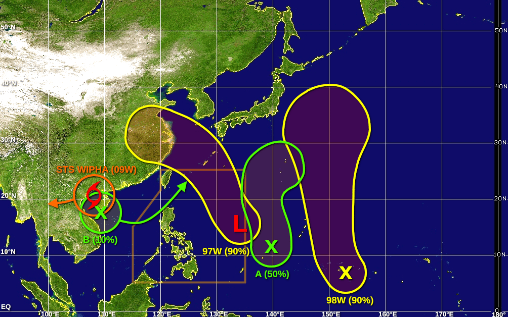
Note: At the time this product was prepared, there was an outage of Himawari-9 full disk satellite data. As a result, this graphic was made with a blank map and without a surface analysis.
Active tropical cyclones:
Severe Tropical Storm Wipha (09W), over the Gulf of Tonkin. Refer to tropical cyclone advisories.
Disturbances/invest areas:
Invest 97W (east-northeast of Samar): A sprawling monsoonal low pressure system located east-northeast of the Philippines is beginning to show some signs of consolidation. In addition, scatterometer data indicates the system has a broad but well defined circulation with winds of 15 to 20 knots along the southern and eastern periphery of its circulation. Upper-level winds are currently only marginally conducive for development, but they are expected to become somewhat more favorable during the next couple of days. A tropical depression is likely to form by Wednesday as the system moves generally northwestward. Interests in the Yaeyama and Ryukyu Islands, including Okinawa, should monitor the progress of this system. Also, this system will likely contribute to increased monsoonal rainfall over portions of northern and central Luzon during the next several days. For additional information, refer to products from your local weather office.
Formation chance through 48 hours: HIGH - 70% 🔴
Formation chance through 7 days: HIGH - 90% 🔴
Invest 98W (east of Chuuk): A large area of disturbed weather located over western Micronesia is associated with a trough of low pressure. An area of low pressure is forecast to form along this trough during the next day or two. Upper-level winds are expected to be conducive for development, and a tropical depression is likely to form by Wednesday or Thursday as this system passes just to the east of Guam and the CNMI. Interests on those islands should monitor the progress of this system.
Formation chance through 48 hours: MEDIUM - 60% 🟠
Formation chance through 7 days: HIGH - 90% 🔴
Disturbance A (northeast of Yap): Another area of low pressure is expected to form along the monsoon trough to the northeast of Yap by midweek. Upper-level winds are expected to be conducive for development, and a short-lived tropical depression could form by Thursday or Friday as the system moves northward over open waters. By the end of the week, this system will likely merge with 98W.
Formation chance through 48 hours: LOW - 10% 🟡
Formation chance through 7 days: MEDIUM - 50% 🟠
Disturbance B (south of Hainan Island): Another monsoonal area of low pressure, unrelated to Tropical Storm Wipha, is likely to form at the entrance of the Gulf of Tonkin just south of Hainan Island by the end of the week. Any development of this system will likely be slow to occur due to unfavorable upper-level winds as it moves in an unusual northeastward motion within the monsoon trough.
Formation chance through 48 hours: VERY LOW - 0% ⚫
Formation chance through 7 days: LOW - 10% 🟡