- Will Weaver's Weather & Pacific Typhoon Center
- Posts
- WPAC Tropical Weather Outlook: 7/11/25
WPAC Tropical Weather Outlook: 7/11/25
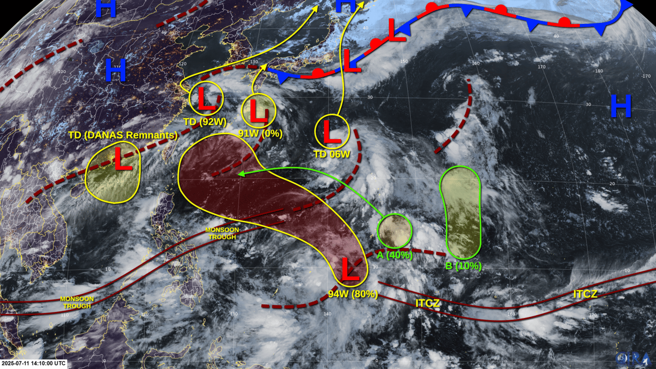
Monsoonal mayhem continues. Tropical Depression 06W is headed for Japan, while Invest 92W is now also a tropical depression. The remnants of Danas are hanging around, and Invest 94W looks like it could be a major issue next week.

Active tropical cyclones:
Tropical Depression 06W, located just west of Iwo Jima. Refer to tropical cyclone advisories.
Tropical Depression (92W): A minor tropical depression is located near 29.7°N 124.6°E, southeast of Shanghai. Estimated winds are 30 knots and pressure is 1004 hPa. This system does not meet warning criteria. The circulation of this system has increased quite a bit in definition during the past 24 hours, although most of the shower activity is displaced to the northeast of the center and the system resembles a subtropical system rather than a purely tropical one. The system is forecast to meander in the East China Sea for a couple of days before an approaching trough causes it to accelerate northeastward toward South Korea and Japan, and it could become a tropical storm on Sunday or Monday before reaching those locations. The system is expected to become a post-tropical cyclone over the Sea of Japan early next week.
Tropical Depression (Remnants of Danas): A minor tropical depression, the remnants of Typhoon Danas, is located near 23.0°N 114.0°E, just inland northwest of Hong Kong. Estimated winds are 20 knots and pressure is 998 hPa. This system does not meet warning criteria. The circulation of Danas has increased somewhat in definition and JMA has redesignated it a minor tropical depression. However, it is forecast to remain either over land or just over water in a rather hostile environment, and it is unlikely to strengthen any further before dissipating within the trough extending from 92W.
Disturbances/invest areas:
Invest 91W is located near the Ryukyu Islands. Although shower activity associated with it has increased somewhat, it is not expected to develop into a tropical cyclone before merging with either 92W or 06W over the weekend.
Formation chance through 48 hours: VERY LOW - 0%
Formation chance through 7 days: VERY LOW - 0%
Invest 94W (southwest of Guam): A broad low pressure area has formed along an active surface trough located south and southwest of Guam, and is producing a large area of widespread showers and thunderstorms. Upper-level winds are not currently favorable for development, but they are forecast to become more favorable by early next week, and a tropical depression is likely to form by Monday or Tuesday as the system moves erratically west-northwestward.
Formation chance through 48 hours: LOW - 10%
Formation chance through 7 days: HIGH - 80%
Disturbance A (east of Guam and Rota): Another area of low pressure is forecast to form along the same surface trough east of Guam and Rota over the weekend. Upper-level winds are expected to be only marginally conducive for development, but this system could become a tropical depression early next week as it moves generally westward in an erratic motion, interacting with 94W as it goes.
Formation chance through 48 hours: VERY LOW - 0%
Formation chance through 7 days: MEDIUM - 40%
Disturbance B (northwest of Pohnpei): Still another area of low pressure is expected to form along this active trough by the middle of next week. Any development of this system will likely be slow to occur as it moves northward due to strong upper-level winds.
Formation chance through 48 hours: VERY LOW - 0%
Formation chance through 7 days: LOW - 10%