- Will Weaver's Weather & Pacific Typhoon Center
- Posts
- Typhoon Sinlaku (04W) – Tropical Cyclone Advisory #19: 1200 UTC 17 April 2026
Typhoon Sinlaku (04W) – Tropical Cyclone Advisory #19: 1200 UTC 17 April 2026
Sinlaku slowly moving away from the northernmost Marianas.
Will Weaver
April 17, 2026
…Sinlaku slowly moving away from the northernmost Marianas…

Himawari-9 infrared satellite image (Weathernerds)
Current storm information:
Position: 20.6°N 146.2°E
Movement: NNE at 7 knots (10 km/h)
Intensity: 80 knots (150 km/h)
Intensity category: 1
Central pressure: 971 hPa
Trend:
Steady weakening is forecast during the next 24 hours.
Watches and warnings:
Areas that should monitor this system:
| Hazards affecting land:
|
Discussion:
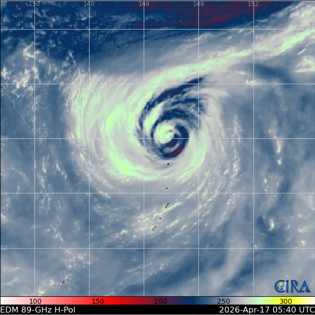
Sinlaku is continuing to struggle against an increasingly unfavorable environment, and its satellite presentation has continued to degrade during the past several hours. A great deal of drier air has infiltrated its circulation, and most of the central convection in the northwestern quadrant outside the eyewall has dissipated. The eye has become cloud-filled and much less distinct, although it is significantly larger than what conventional satellite imagery would suggest. Moisture associated with Sinlaku is advecting along a frontal boundary positioned to the north and northeast of the system, although this front is not doing much to help Sinlaku along on its track and steering currents are quite weak. Manual Dvorak fixes from PGTW and KNES are a consensus T4.5 with CIMSS ADT and D-PRINT estimates ranging from 77 to 84 kts; taking a blend of these data supports leaving the intensity at 80 kts.
While Sinlaku is currently interacting with a frontal system, this interaction is not expected to result in extratropical transition just yet. Most of the available guidance expects this front to leave Sinlaku behind in an area of weak steering currents, so a rather slow northeasterly motion is expected to persist for another 24 to 36 hours or so. Sinlaku should not be parked for very long, however, as another trough expected to move off the coast of Japan on Saturday should finally force Sinlaku on its way and allow it to be captured by the mid-latitude westerlies. The extra baroclinic energy should also rapidly complete its extratropical transition, and Sinlaku is expected to become a post-tropical cyclone by Sunday or Monday. The post-tropical cyclone should weaken as it races toward the International Date Line. It is beginning to appear likely that Sinlaku will be absorbed by a large extratropical low southeast of the Aleutian Islands just after crossing the Date Line rather than reintensify as a distinct entity, and this is now indicated in the forecast.
Forecast positions and maximum winds (1-min)
000 hrs: 20.6°N 146.2°E – 80 kts 150 km/h
012 hrs: 22.4°N 146.8°E – 65 kts 120 km/h
024 hrs: 24.3°N 147.5°E – 50 kts 95 km/h
048 hrs: 28.0°N 152.9°E – 45 kts 85 km/h POST-TROPICAL/EXTRATROPICAL
072 hrs: 29.1°N 162.7°E – 40 kts 75 km/h POST-TROPICAL/EXTRATROPICAL
096 hrs: 31.5°N 175.5°E – 35 kts 65 km/h POST-TROPICAL/EXTRATROPICAL
120 hrs: ABSORBED BY EXTRATROPICAL LOW

Forecast map (click to enlarge)