- Will Weaver's Weather & Pacific Typhoon Center
- Posts
- Typhoon Sinlaku (04W) – Tropical Cyclone Advisory #15: 1200 UTC 15 April 2026
Typhoon Sinlaku (04W) – Tropical Cyclone Advisory #15: 1200 UTC 15 April 2026
Typhoon conditions continuing on Tinian and Saipan as Sinlaku moves slowly away from the islands.
Will Weaver
April 15, 2026
…Typhoon conditions continuing on Tinian and Saipan as Sinlaku moves slowly away from the islands…

Himawari-9 infrared satellite image (Weathernerds)
Current storm information:
Position: 16.2°N 144.6°E
Movement: NW at 5 knots (10 km/h)
Intensity: 110 knots (205 km/h)
Intensity category: 3
Central pressure: 940 hPa
Trend:
A slow weakening trend is expected during the next 24 hours.
Watches and warnings:
Areas that should monitor this system:
| Hazards affecting land:
|
Discussion:

METOP-B MHS 89GHz microwave satellite image (RAMMB/CIRA)
Sinlaku continues to go nowhere fast and is continuing to pound the Commonwealth of the Northern Mariana Islands with typhoon conditions. The typhoon’s satellite presentation has continued to gradually degrade as it moves over slowly cooling SSTs and wraps up an eyewall replacement cycle. Although Sinlaku continues to have a very large, clear, and relatively warm (about 15°C) eye, convection within the CDO and eyewall is somewhat ragged. Microwave satellite imagery also indicates that Sinlaku still has a concentric eyewall structure with a moat of dry air separating the inner eyewall from a much larger outer eyewall. This dry air is starting to eat away at the CDO as well, as dry slots are starting to show up within the northeastern quadrant. Outflow remains excellent in all quadrants. Dvorak estimates range from T5.5 to T6.0 with ADT and D-PRINT averaging out at around 100 kts; taking a blend of these data results in holding the intensity at 110 kts.

Attempting to calculate Sinlaku’s minimum pressure at its peak intensity. The crossed out things are because I really suck at math.
Some interesting observations from Saipan during Sinlaku’s passage suggest that it may have had a higher peak intensity. The current peak intensity as indicated by JTWC was 160 kts and 890 hPa at 1800 UTC on April 12th. However, as Sinlaku passed over Saipan, weather stations reported pressures as low as 910 hPa after correcting for calibration and bias. Given that Sinlaku was clearly weaker at that time, this suggests that even such a low minimum pressure of 890 hPa might be too high. Using the Knaff-Zehr wind-pressure relationship equation, I calculated a pressure of 882 hPa at peak. While this could be wrong - after all, I am not a meteorologist and I will be the first to tell you that math is not my strong suit - others have gotten similar results, and this could be closer to reality. We’ll have to see what happens in post-storm analysis.

Himawari-9 false-color RGB proxy visible image (Dapiya/xiaoquanWX)
Anyway, back to right now. Sinlaku remains in a col region between two competing subtropical ridges, hence its slow forward motion. The ridge to the west is gradually eroding as a trough amplifies off the coast of Japan, which should result in Sinlaku turning northward and accelerating later tonight and tomorrow. A turn toward the northeast is expected on Saturday as Sinlaku rounds the subtropical ridge and recurves into the mid-latitude westerlies. Steady weakening is forecast as Sinlaku moves over cooler SSTs, and by this weekend, increasing shear should cause a faster rate of weakening. While the current trough is likely to leave Sinlaku behind, another frontal system approaching from the northwest should interact with it and cause it to become a post-tropical cyclone by Sunday or Monday as it races eastward across the northern Pacific.
Forecast positions and maximum winds (1-min)
000 hrs: 16.2°N 144.6°E – 110 kts 205 km/h
012 hrs: 17.2°N 144.5°E – 105 kts 195 km/h
024 hrs: 18.5°N 144.5°E – 95 kts 175 km/h
048 hrs: 22.1°N 145.8°E – 75 kts 140 km/h
072 hrs: 24.8°N 148.2°E – 60 kts 110 km/h
096 hrs: 28.3°N 154.3°E – 50 kts 95 km/h POST-TROPICAL/EXTRATROPICAL
120 hrs: 31.3°N 167.9°E – 45 kts 85 km/h POST-TROPICAL/EXTRATROPICAL
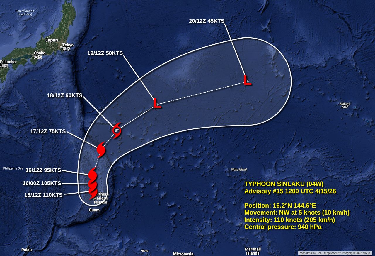
Forecast map