- Will Weaver's Weather & Pacific Typhoon Center
- Posts
- Typhoon Ragasa (24W) – Tropical Cyclone Advisory #13: 1200 UTC 23 September 2025
Typhoon Ragasa (24W) – Tropical Cyclone Advisory #13: 1200 UTC 23 September 2025
Extremely dangerous Category 4 Ragasa to pass just south of Hong Kong and Macau overnight tonight into tomorrow.
Will Weaver
September 23, 2025
…Extremely dangerous Category 4 Ragasa to pass just south of Hong Kong and Macau overnight tonight into tomorrow… …Destructive winds and life-threatening storm surge expected…
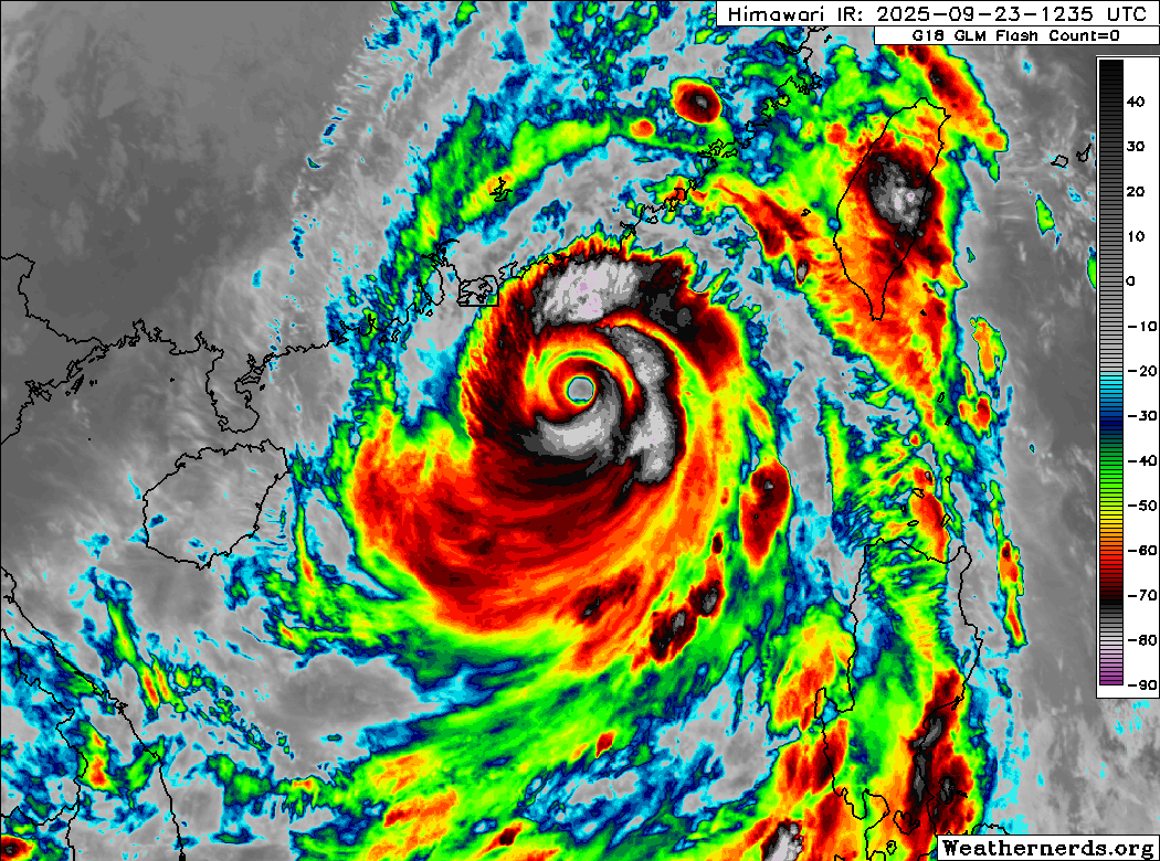
Himawari-9 infrared satellite image (Weathernerds)
Current storm information:
Position: 20.8°N 116.1°E
Movement: WNW at 10 knots (20 km/h)
Intensity: 115 knots (215 km/h) [Category 4]
Central pressure: 925 hPa
Trend:
Gradual weakening is expected during the next 24 hours.
Watches and warnings:  PAGASA wind signal map (click to enlarge)
| Hazards affecting land:
|
Discussion:
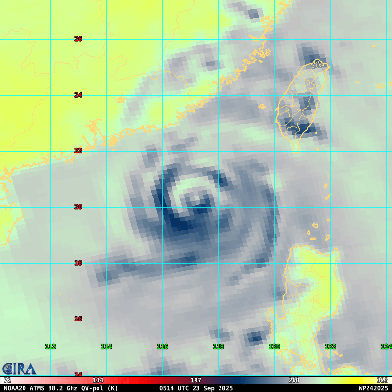
NOAA-20 ATMS 89GHz microwave satellite image
Ragasa is continuing to show signs of weakening as it moves into an environment that cannot sustain a tropical cyclone as intense as it was yesterday. Convective cloud tops within the central dense overcast’s northern semicircle have continued to warm and there is evidence of dry air intrusion. In addition, it seems that shear may be starting to increase as there is feathering of the convection along the northern edge of the CDO. Ragasa continues to sport a concentric eyewall structure, and the inner eyewall remains very well defined, clear, and warm, and the typhoon still has impressive radial outflow in all quadrants, which is probably helping offset any upwelling that is occurring as Ragasa moves over shallower waters. Dvorak fixes are a consensus T6.0 with CIMSS ADT and D-PRINT estimates being about the same, so the intensity is lowered to 115 kts. Ragasa remains an extremely dangerous Category 4 typhoon.
There are no changes to the forecast. A ridge is currently building westward over eastern China, and this should support a continued west to west-northwestward motion during the next day or two. Ragasa is expected to encounter slightly stronger shear and shallower waters, but given its structure, the circulation will probably take some time to spin down and Ragasa is expected to remain a very intense system as it passes south of Hong Kong and Macau overnight tonight into Wednesday. Ragasa should make landfall near the northern end of the Leizhou Peninsula late Wednesday night, which should result in more rapid weakening. How quickly Ragasa weakens after landfall will depend on whether the center reemerges over the Gulf of Tonkin on Thursday. The forecast currently indicates that it will, but some of the model guidance keeps the center inland. If Ragasa moves over the Gulf of Tonkin, it may weaken less quickly before it moves over Vietnam late Thursday night or early Friday. Dissipation is expected late Friday as Ragasa pushes inland.
Forecast positions and maximum winds
00 hrs: 20.8°N 116.1°E – 115 kts
12 hrs: 21.4°N 113.8°E – 105 kts
24 hrs: 21.4°N 111.3°E – 100 kts
48 hrs: 21.5°N 106.0°E – 45 kts inland
72 hrs: 21.3°N 101.5°E – 25 kts inland
96 hrs: Dissipated
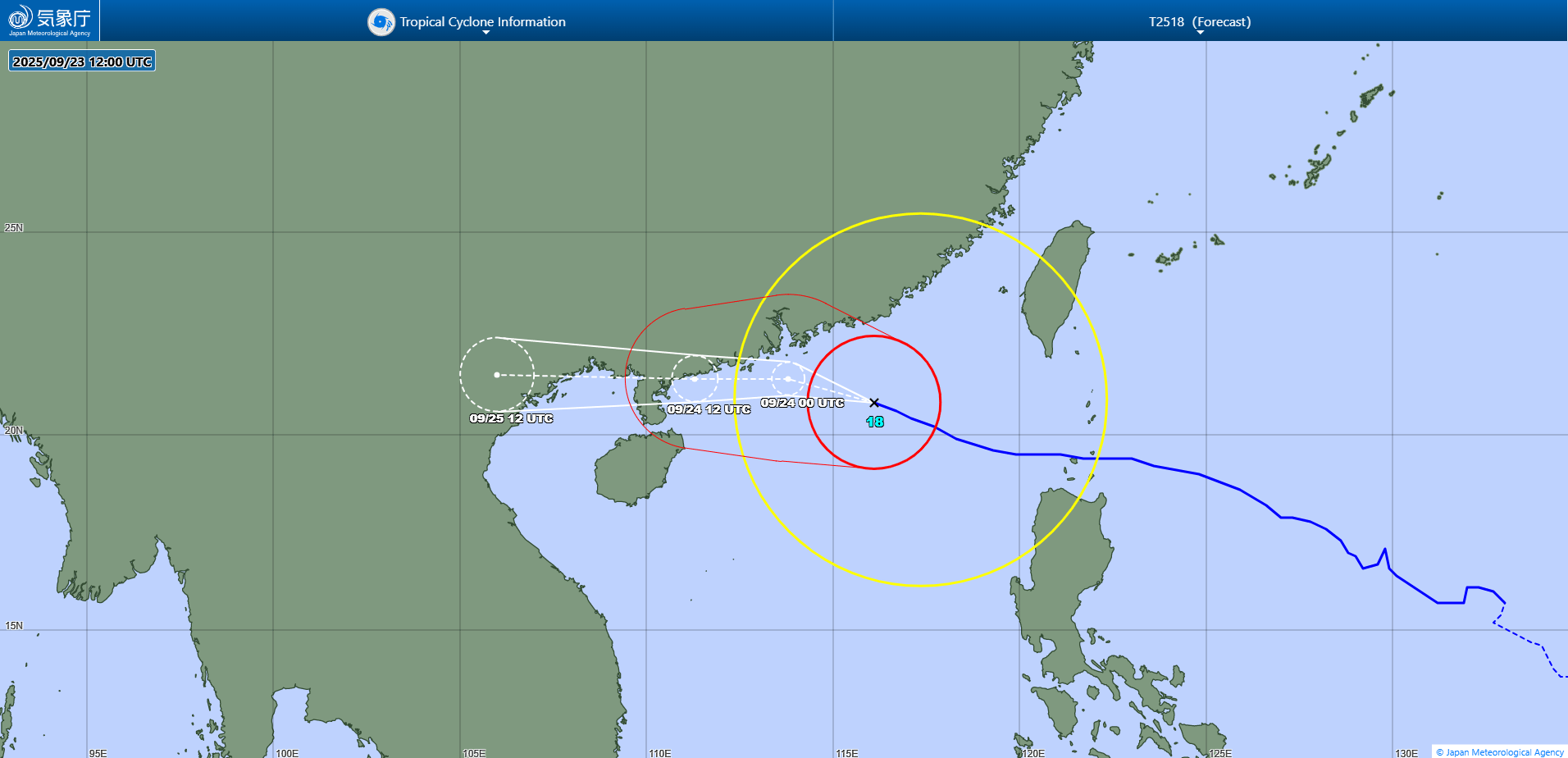
JMA forecast map