- Will Weaver's Weather & Pacific Typhoon Center
- Posts
- Typhoon Ragasa (24W/Nando) – Tropical Cyclone Advisory #6: 0000 UTC 20 September 2025
Typhoon Ragasa (24W/Nando) – Tropical Cyclone Advisory #6: 0000 UTC 20 September 2025
Ragasa becomes a typhoon, expected to intensify at a much faster rate today. Interests in the Philippines, Taiwan, Hong Kong, and Macau need to be making preparations.
Will Weaver
September 19, 2025
…Ragasa becomes a typhoon… …Expected to intensify at a much faster rate today…

Himawari-9 visible satellite loop (Weathernerds)
Current storm information:
Position: 16.7°N 129.6°E
Movement: WNW at 5 knots (10 km/h)
Intensity: 65 knots (120 km/h) [Category 1]
Central pressure: 985 hPa
Trend:
Ragasa is forecast to rapidly intensify today. It could become a Category 3 typhoon by tonight and a Category 4 typhoon on Sunday.
Watches and warnings:
| Hazards affecting land:
|
Discussion:
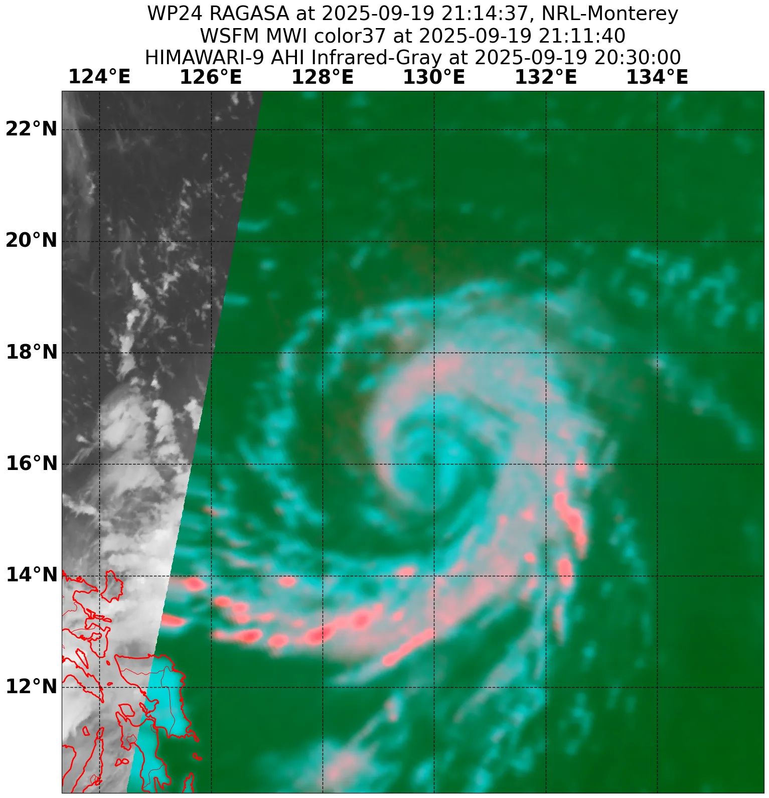
WSFM MWI 37GHz microwave satellite image
Ragasa appears to be on the cusp of its long-anticipated rapid intensification phase. The subsidence that had been impacting it has subsided, and the tropical cyclone’s structure has immediately responded. Convection has wrapped all the way around the center and an eye has quickly formed and partially cleared out, with a nearly complete eyewall present on microwave satellite imagery. Numerous convective hot towers are flaring within the eyewall. The overall convective structure has taken on what some refer to as the “shrimp structure”, in that convection has wrapped tightly into the center with a dry slot present that has not yet been filled in with convection, and the system exhibits excellent radial outflow. Dvorak estimates range from T4.0 to T4.5 with CIMSS ADT and D-PRINT estimates of 58 and 77 kts; the intensity is increased to a potentially conservative 65 kts, making Ragasa a typhoon.
There are no changes to the track or intensity forecasts. Ragasa is beginning to enter a much more favorable environment with low shear, excellent outflow, and very warm SSTs, and all of the available rapid intensification guidance is nearly maxed out. RIPA guidance suggests a nearly 50% chance of an increase of 70 kts in the next 48 hours. Ragasa should intensify very rapidly today and tonight, and it’s possible Ragasa could be near Category 4 strength within the next 24 hours. Ragasa is expected to reach peak intensity on Monday as it passes almost directly between the Batanes and Babuyan Islands. It should be noted that there is still a fair amount of spread among the track guidance, although most GFS and ECMWF ensemble member tracks have shifted northward away from northern mainland Luzon. However, it is expected that Ragasa’s wind field will be expansive enough that tropical storm conditions are possible along the Luzon and Taiwan coastline on Monday into Tuesday. Although the monsoon trough is currently quite weak, some enhanced rainfall is possible over portions of central and southern Luzon during that time as well.
On Tuesday evening, a weakening trend is expected to begin as Ragasa encounters a slight increase in shear and interacts with a gap wind event in the Taiwan Strait. The strong surface flow will likely nudge Ragasa toward the west-southwest, although it will likely still be a very intense system as it passes very close to Hong Kong and Macau on Wednesday and the Leizhou Peninsula of China on Thursday.
Forecast positions and maximum winds
00 hrs: 16.7°N 129.6°E – 65 kts
12 hrs: 17.3°N 128.6°E – 95 kts
24 hrs: 18.2°N 127.4°E – 115 kts
48 hrs: 19.8°N 123.9°E – 135 kts
72 hrs: 20.8°N 119.0°E – 130 kts
96 hrs: 21.9°N 114.4°E – 115 kts
120 hrs: 21.0°N 110.2°E – 90 kts inland

JMA forecast map