- Will Weaver's Weather & Pacific Typhoon Center
- Posts
- Typhoon Koto (33W) – Tropical Cyclone Advisory #8: 1200 UTC 27 November 2025
Typhoon Koto (33W) – Tropical Cyclone Advisory #8: 1200 UTC 27 November 2025
Koto meandering near the Spratly Islands...
Will Weaver
November 27, 2025
…Koto meandering near the Spratly Islands…

GEO-KOMPSAT-2A infrared satellite image (CyclonicWx)
Current storm information:
Position: 12.8°N 113.8°E
Movement: Nearly stationary
Intensity: 70 knots (130 km/h) [Category 1]
Central pressure: 974 hPa
Trend:
Gradual weakening is forecast during the next 24 hours.
Watches and warnings:
| Hazards affecting land:
|
Discussion:

Koto has suddenly taken on a sheared appearance as it continues to lurk northwest of the Spratly Islands. The central dense overcast has become disrupted with clusters of intense convection flaring to the west of the center, and the eye is no longer distinct on conventional or microwave satellite imagery. Shortwave infrared satellite imagery suggests that the low- and mid-level centers are becoming decoupled by southeasterly shear, as low cloud lines are starting to become visible to the southeast of the convective mass. Dvorak fixes range from T4.0 to T4.5 while CIMSS ADT and D-PRINT estimates range from 58 to 63 kts; taking a blend of these data yields an intensity of 70 kts.
Koto remains in an area of weak steering currents between two competing subtropical ridges, and this situation is not likely to change during the next few days. Koto is forecast to continue moving slowly and erratically westward through the end of the forecast period. Increasing shear, infiltration of cooler, drier air from the northeast monsoon, and cooling SSTs should result in a progressive weakening trend during that time. Although the average of the model tracks suggests a slow west-northwesterly motion, some of the guidance indicates that Koto could turn sharply to the southwest within the cold surge flow by the end of the forecast period.
Forecast positions and maximum winds (1-min)
000 hrs: 12.8°N 113.8°E – 70 kts 130 km/h
012 hrs: 12.7°N 113.3°E – 60 kts 110 km/h
024 hrs: 12.9°N 112.9°E – 50 kts 95 km/h
048 hrs: 13.6°N 112.6°E – 40 kts 75 km/h
072 hrs: 14.1°N 112.4°E – 40 kts 75 km/h
096 hrs: 14.3°N 111.6°E – 40 kts 75 km/h
120 hrs: 14.4°N 110.7°E – 35 kts 65 km/h
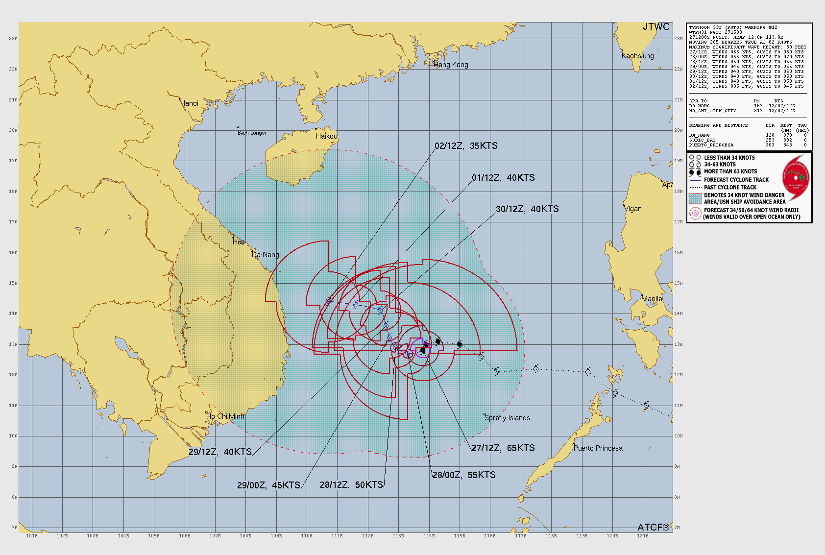
JTWC forecast map