- Will Weaver's Weather & Pacific Typhoon Center
- Posts
- Typhoon Kajiki (19W) – Tropical Cyclone Advisory #6: 1500 UTC 24 August 2025
Typhoon Kajiki (19W) – Tropical Cyclone Advisory #6: 1500 UTC 24 August 2025
Rapidly intensifying Kajiki entering the Gulf of Tonkin as a strong Category 2 typhoon
Will Weaver
August 24, 2025
…Rapidly intensifying Kajiki entering the Gulf of Tonkin as a strong Category 2 typhoon… …Expected to make landfall in Vietnam on Monday evening at Category 3 strength…

Himawari-9 infrared satellite image (Weathernerds)
Current storm information:
Position: 18.0°N 108.8°E
Movement: WNW at 10 knots (20 km/h)
Intensity: 95 knots (175 km/h) [Cat 2]
Central pressure: 950 hPa
Trend:
Additional strengthening is forecast during the next 24 hours, and Kajiki is expected to become a Category 3 typhoon later tonight.
Watches and warnings:
| Hazards affecting land:
|
Discussion:

WSFM MWI 89GHz microwave satellite image
Kajiki has become an extremely impressive typhoon considering its location. Although a slight amount of land interaction has occurred as the northern semicircle has passed over Hainan Island, Kajiki continues to sport an intense and symmetric central dense overcast with a small, ragged eye feature. Radar data indicates the eye has shrunk somewhat in size in recent hours due to land interaction and the eyewall is slightly fragmented on its northern side, but intense convection has already begun to redevelop and wrap around the eye again. Kajiki continues to show impressive radial outflow in all quadrants. The current intensity of 95 kts is based on T5.0 to T5.5 Dvorak fixes from the various agencies, a CIMSS D-PRINT estimate of 92 kts, and a SATCON estimate of 102 kts. The radius of typhoon force winds is relatively compact, as Sanya on Hainan Island recently reported 10-minute sustained winds of 52 kts, gusting to 68 kts.
With the compact core of Kajiki now moving away from Hainan Island, conditions appear conducive for Kajiki to continue strengthening. CIMSS AI-RI and RAMMB RIPA guidance indicate high probabilities of rapid intensification during the next 24 hours, with RIPA being most aggressive at a 47.1% chance of an increase of 40 kts during the next 24 hours. The JMA and JTWC forecasts are a bit too conservative given these factors, and the intensities given in the table below are higher as a result. Kajiki will likely be a strong and extremely dangerous Category 3 typhoon as it makes landfall in Vietnam near Vinh on Monday evening. Rapid weakening is forecast after landfall, and Kajiki should become a remnant low over Myanmar on Tuesday night and dissipate soon after.
Forecast positions and maximum winds
00 hrs: 18.0°N 108.8°E – 95 kts
12 hrs: 18.4°N 107.3°E – 110 kts
24 hrs: 18.8°N 105.0°E – 65 kts inland
48 hrs: 19.7°N 100.2°E – 30 kts Post-tropical/remnant low inland
72 hrs: Dissipated
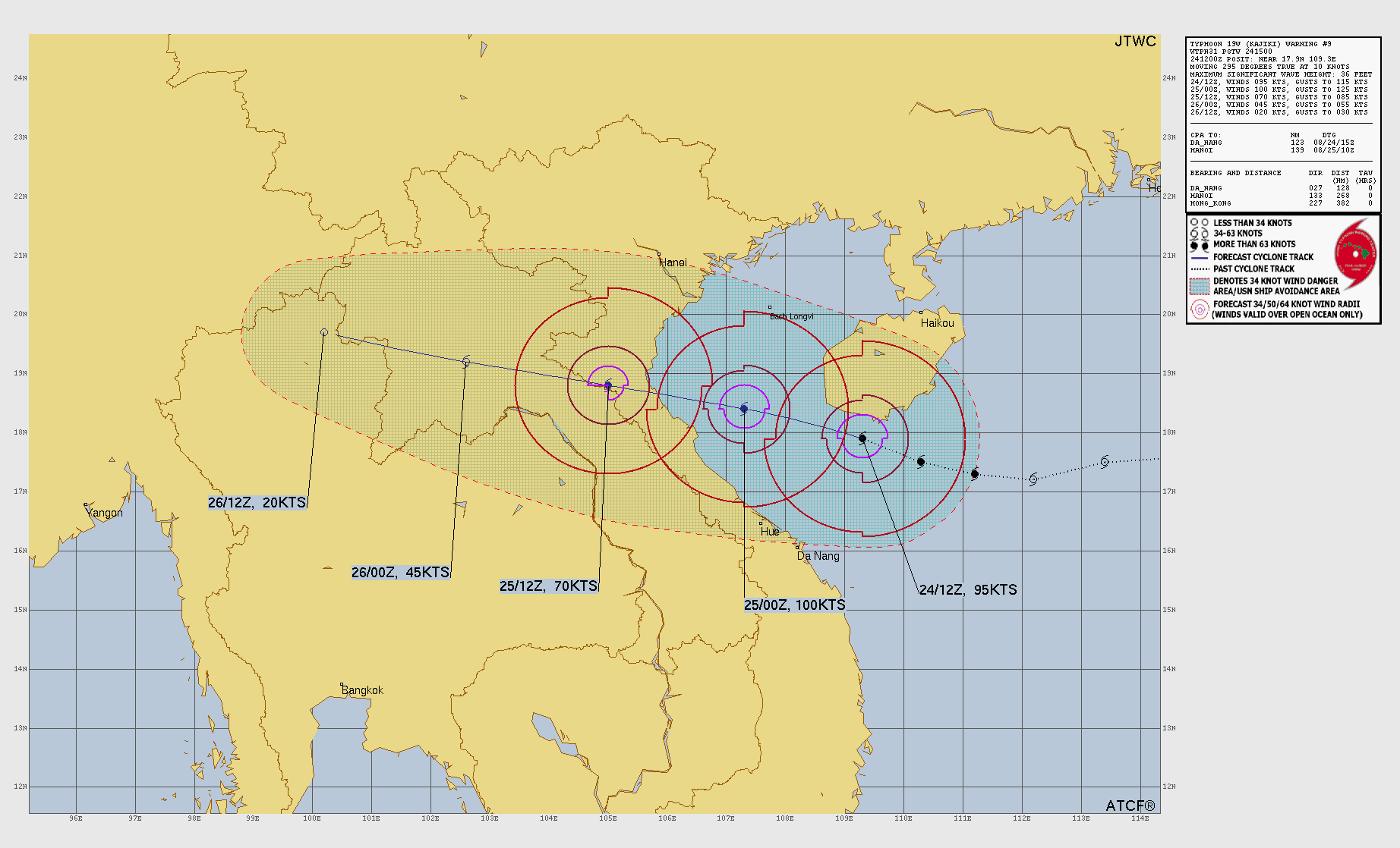
JTWC forecast map
One last thing…
Please consider sending a tip via Ko-fi! I wear a lot of hats between a day job, being a photographer, and being a worldwide weather enthusiast, and while I will never put any of my content behind a paywall (paywalls kind of defeat the purpose of this blog/newsletter/thingy), your tips definitely help! You can send a tip via the following link: https://ko-fi.com/willweaverrva