- Will Weaver's Weather & Pacific Typhoon Center
- Posts
- Typhoon Halong (28W) – Tropical Cyclone Advisory #7: 1500 UTC 7 October 2025
Typhoon Halong (28W) – Tropical Cyclone Advisory #7: 1500 UTC 7 October 2025
Halong rapidly intensifies into an extremely dangerous Category 4 typhoon.
Will Weaver
October 07, 2025
…Halong rapidly intensifies into an extremely dangerous Category 4 typhoon…
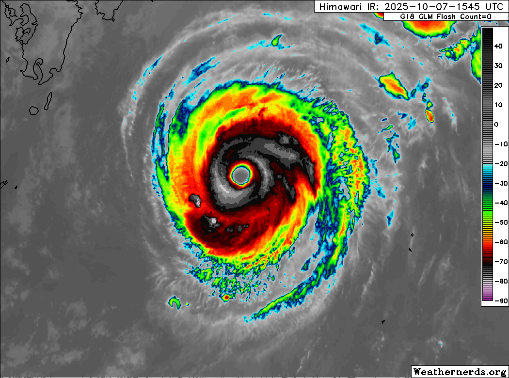
Himawari-9 infrared satellite image (Weathernerds)
Current storm information:
Position: 28.4°N 137.2°E
Movement: NW at 7 knots (10 km/h)
Intensity: 115 knots (215 km/h) [Category 4]
Central pressure: 942 hPa
Trend:
Additional strengthening is likely during the next 24 hours and Halong could become a super typhoon on Wednesday.
Watches and warnings:
| Hazards affecting land:
|
Discussion:
Halong has very quickly become a compact yet impressive typhoon over open waters. Thanks to an unusually favorable environment in the subtropical Pacific, Halong has a nearly annular satellite presentation, consisting of a “truck tire” central dense overcast with few rainbands extending from it surrounding a very large, warm, and clear eye. Cloud tops within the eyewall are quite cold, although the temperatures have been fluctuating during the past few hours. Microwave satellite imagery depicts an intense eyewall with no sign of concentric eyewalls. The current intensity of 115 kts is based on consensus T6.0 Dvorak fixes, although ADT and D-PRINT estimates are slightly higher.
Halong is in the process of making its sharp turn back toward the east-northeast, and it is now moving slowly northwestward through a weakness in the subtropical ridge. With shear being almost nonexistent and SSTs remaining fairly warm, it is likely that Halong will continue to strengthen for another day or so. Although it is not explicitly indicated below, Halong could briefly become a super typhoon (130 kts) sometime on Wednesday. By late Thursday, Halong should begin to encounter increasing shear and cooler waters, which should result in steady to rapid weakening. As Halong accelerates east-northeastward out into the Pacific, it will receive a major baroclinic kick from a pool of very cold air southeast of the Kuril Islands, and this should result in Halong becoming a hurricane-force post-tropical cyclone on Saturday. As post-tropical Halong leaves the Western Pacific basin, it should turn northeastward and rapidly intensify as it interacts with another extratropical low in the Bering Sea, and it could bring hurricane-force winds and heavy rain and snow to portions of western Alaska early next week.
Although Halong is expected to remain offshore of Japan, it is likely to pass close enough to potentially produce dangerous and life-threatening conditions along the southern and southeastern coasts of Honshu during the next couple of days.
Forecast positions and maximum winds
000 hrs: 28.4°N 137.2°E – 115 kts
012 hrs: 30.0°N 137.0°E – 125 kts
024 hrs: 31.8°N 138.3°E – 125 kts
048 hrs: 33.8°N 144.6°E – 115 kts
072 hrs: 34.4°N 158.6°E – 85 kts
096 hrs: 40.5°N 176.6°E – 65 kts Post-tropical/extratropical
120 hrs: 56.8°N 172.0°W – 80 kts Post-tropical/extratropical
JTWC forecast map