- Will Weaver's Weather & Pacific Typhoon Center
- Posts
- Typhoon Halong (28W) – Tropical Cyclone Advisory #12: 0000 UTC 10 October 2025
Typhoon Halong (28W) – Tropical Cyclone Advisory #12: 0000 UTC 10 October 2025
Halong forecast to take a journey into the Arctic as a post-tropical cyclone.
Will Weaver
October 09, 2025
…Halong forecast to take a journey into the Arctic as a post-tropical cyclone…
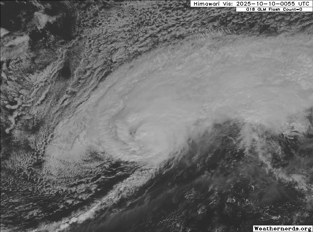
Himawari-9 visible satellite image (Weathernerds)
Current storm information:
Position: 34.4°N 154.8°E
Movement: E at 30 knots (55 km/h)
Intensity: 65 knots (155 km/h) [Category 1]
Central pressure: 975 hPa
Trend:
Little change in strength is forecast during the next 24 hours, and Halong should become a post-tropical cyclone later today.
Watches and warnings:
| Hazards affecting land:
|
Discussion:
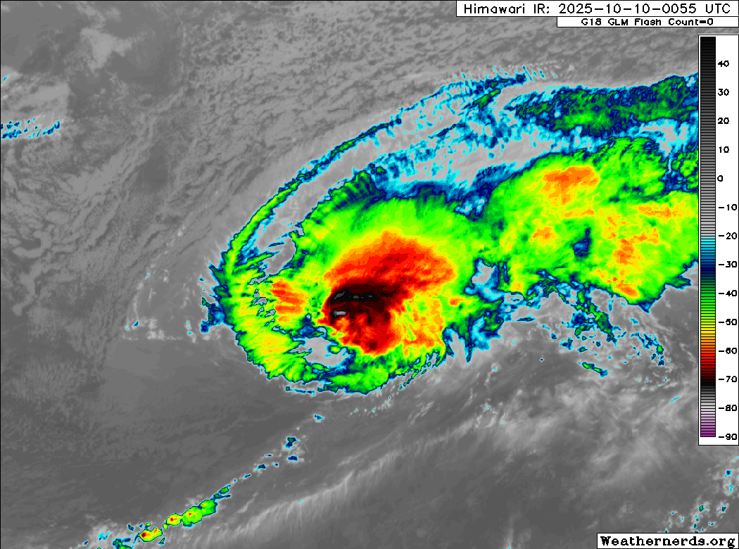
Himawari-9 infrared satellite image (Weathernerds)
Halong is just about extratropical. The typhoon has continued to take on a non-tropical satellite presentation with well-defined warm and cold fronts very close to its center. Most of the convection is displaced well to the northeast of the center along a frontal boundary, although the center stubbornly continues to generate deep convection. This convection is enough for KNES, RJTD, and PGTW to classify Halong with the Dvorak technique, and so it remains a 65 kt typhoon at this time.
Halong has crossed the threshold of 26°C SSTs and is now moving over colder waters, and this should very shortly put an end to its efforts to generate convection. Halong should become post-tropical later today. The post-tropical cyclone should turn northeastward and accelerate as it interacts with a deep low pressure area in the western Bering Sea. As it does, it should explosively deepen to around 940 hPa as it passes between Russia and Alaska. The post-tropical cyclone is expected to remain a distinct entity even at the end of the forecast period, when it will be wandering in the Arctic Ocean as a component of the polar vortex.
Forecast positions and maximum winds
000 hrs: 34.4°N 154.8°E – 65 kts
012 hrs: 34.6°N 162.4°E – 60 kts Post-tropical/extratropical
024 hrs: 37.4°N 171.1°E – 55 kts Post-tropical/extratropical
048 hrs: 49.4°N 174.0°W – 55 kts Post-tropical/extratropical
072 hrs: 61.7°N 172.0°W – 65 kts Post-tropical/extratropical
096 hrs: 68.1°N 164.5°W – 55 kts Post-tropical/extratropical inland over Alaska
120 hrs: 76.0°N 147.0°W – 30 kts Post-tropical/extratropical over Arctic Ocean
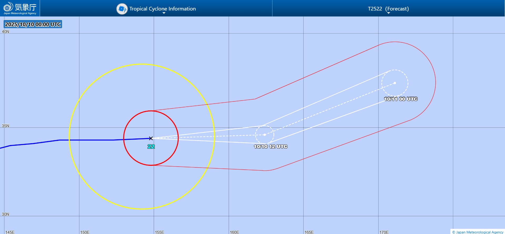
JMA forecast map. Extratropical phase omitted.