- Will Weaver's Weather & Pacific Typhoon Center
- Posts
- Typhoon Halong (28W) – Tropical Cyclone Advisory #11: 1200 UTC 9 October 2025
Typhoon Halong (28W) – Tropical Cyclone Advisory #11: 1200 UTC 9 October 2025
Halong losing tropical characteristics as it accelerates out to sea.
Will Weaver
October 09, 2025
…Halong losing tropical characteristics as it accelerates out to sea…
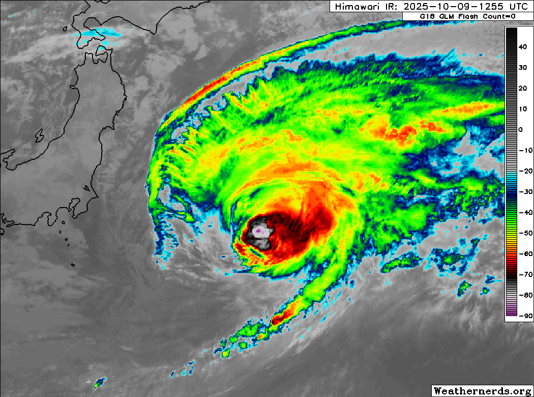
Himawari-9 infrared satellite image (Weathernerds)
Current storm information:
Position: 34.1°N 146.9°E
Movement: E at 28 knots (50 km/h)
Intensity: 85 knots (155 km/h) [Category 2]
Central pressure: 968 hPa
Trend:
Gradual weakening is forecast during the next 24 hours, and Halong should become a post-tropical cyclone on Friday.
Watches and warnings:
| Hazards affecting land:
|
Discussion:
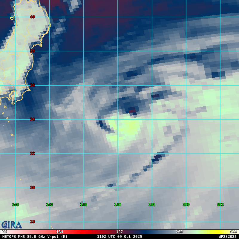
METOP-B MHS 89GHz microwave satellite image
Halong has begun extratropical transition. Although it is moving very rapidly eastward, the typhoon has moved underneath the subtropical jet and is experiencing westerly shear of about 50 to 60 kts, leading to effective shear of about 30 kts. Because of this, convection has very rapidly become lopsided to the north and east of the circulation center. Meanwhile, the eye structure has very quickly collapsed, although the center is continuing to generate deep convection with rather cold cloud tops. The convective structure of Halong is also taking on a non-tropical appearance, resembling the classic extratropical comma shape, and a frontal boundary is rapidly approaching the circulation center from the west. Halong is still over fairly warm SSTs and is continuing to generate central convection, so it is still a tropical cyclone for now. The intensity is lowered to 85 kts, hedged between Dvorak fixes of T5.0 to T5.5 and much lower automated estimates from CIMSS ranging from 70 kts to 85 kts.
Halong is fully embedded within the mid-latitude westerlies and so it should continue moving rapidly eastward for another couple of days. On this track, Halong will soon encounter much colder SSTs, and this will probably put an end to its efforts to produce central convection. Halong is expected to become a powerful hurricane-force post-tropical cyclone on Friday. The post-tropical cyclone is expected to explosively deepen after completing extratropical transition as it interacts with another deep low in the Bering Sea over the weekend. This interaction will cause post-tropical Halong to rocket northeastward, and this may be the first time I have listed a forecast point in the Arctic Ocean in one of these advisories. By the end of the forecast period, post-tropical Halong should rapidly weaken, and it will likely merge with the polar vortex north of Alaska after the end of the forecast period.
Post-tropical Halong is expected to become quite large as it moves into the Bering Sea and Bering Strait, and it is expected to produce storm- or hurricane-force winds over portions of the Russian Far East and western mainland Alaska, in addition to heavy rain and snow. For additional information, refer to products from your local weather office.
Forecast positions and maximum winds
000 hrs: 34.1°N 146.9°E – 85 kts
012 hrs: 34.2°N 153.5°E – 75 kts
024 hrs: 34.4°N 161.4°E – 65 kts Post-tropical/extratropical
048 hrs: 40.5°N 176.8°E – 55 kts Post-tropical/extratropical
072 hrs: 57.5°N 175.2°W – 65 kts Post-tropical/extratropical
096 hrs: 65.2°N 170.6°W – 55 kts Post-tropical/extratropical
120 hrs: 69.0°N 164.0°W – 35 kts Post-tropical/extratropical
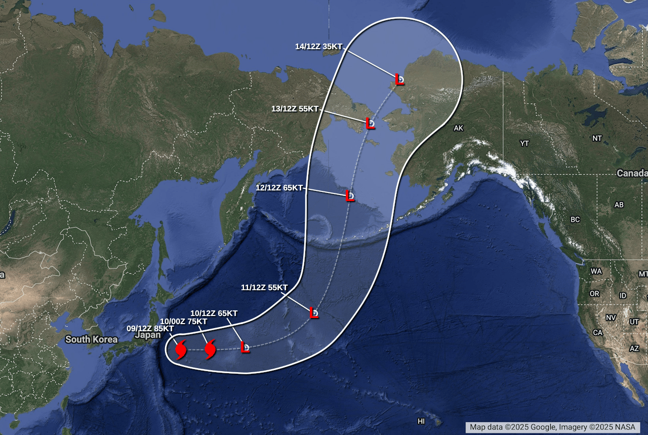
Forecast map