- Will Weaver's Weather & Pacific Typhoon Center
- Posts
- Typhoon Halong (28W) – Tropical Cyclone Advisory #10: 0000 UTC 9 October 2025
Typhoon Halong (28W) – Tropical Cyclone Advisory #10: 0000 UTC 9 October 2025
Halong moving away from Japan. Conditions should begin to improve in the Izu Islands during the next few hours.
Will Weaver
October 08, 2025
…Halong moving away from Japan… …Conditions should begin to improve in the Izu Islands during the next few hours…

Himawari-9 visible satellite image (Weathernerds)
Current storm information:
Position: 33.0°N 141.1°E
Movement: ENE at 16 knots (25 km/h)
Intensity: 105 knots (195 km/h) [Category 3]
Central pressure: 946 hPa
Trend:
Gradual weakening is forecast during the next 24 hours, and Halong will likely become a powerful hurricane-force post-tropical cyclone on Friday.
Watches and warnings:
| Hazards affecting land:
|

WSFM MWI 89GHz microwave satellite image
The next advisory will be posted after 1200 UTC 9 October 2025.
Forecast positions and maximum winds
000 hrs: 33.0°N 141.1°E – 105 kts
012 hrs: 33.9°N 146.0°E – 95 kts
024 hrs: 34.1°N 153.1°E – 80 kts Post-tropical/extratropical
048 hrs: 36.5°N 169.1°E – 60 kts Post-tropical/extratropical
072 hrs: 49.0°N 176.0°W – 60 kts Post-tropical/extratropical
096 hrs: 63.0°N 174.0°W – 65 kts Post-tropical/extratropical
120 hrs: 66.0°N 170.0°W – 55 kts Post-tropical/extratropical inland
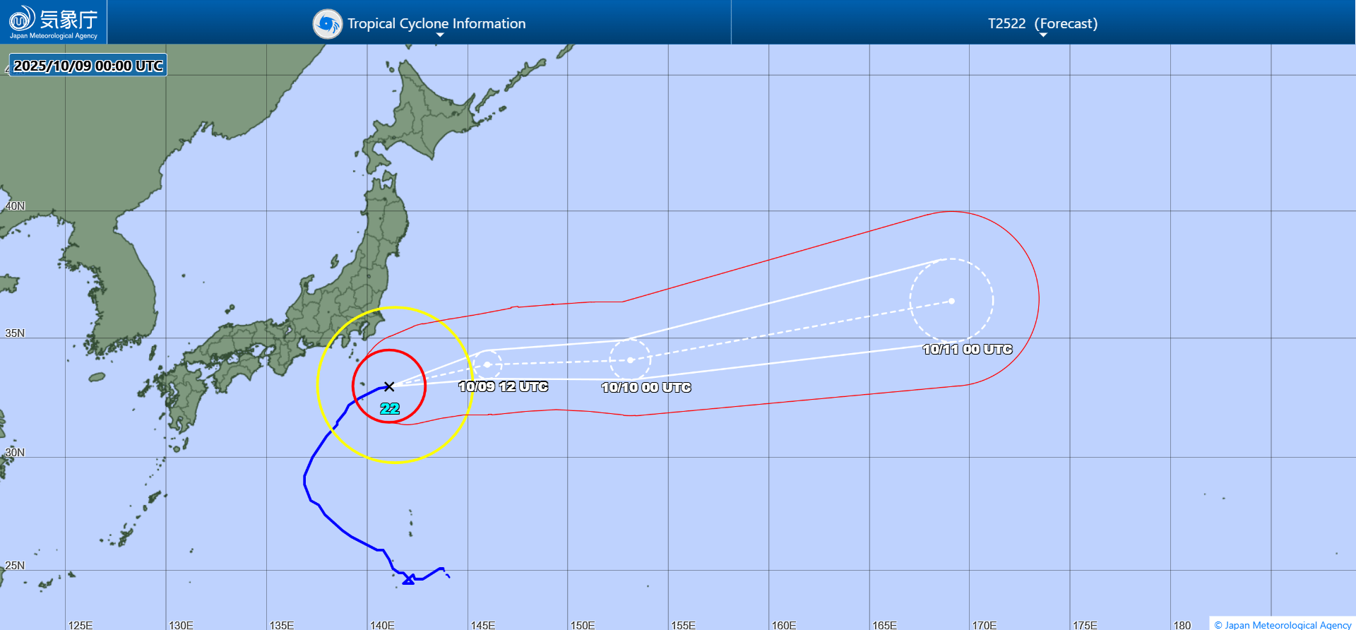
JMA forecast map, extratropical phase omitted (probably good considering the 120 hour position is over the Russian Far East)