- Will Weaver's Weather & Pacific Typhoon Center
- Posts
- Typhoon Fung-wong (32W/Uwan) – Tropical Cyclone Advisory #15: 1500 UTC 10 November 2025
Typhoon Fung-wong (32W/Uwan) – Tropical Cyclone Advisory #15: 1500 UTC 10 November 2025
Fung-wong moving north-northwestward off the northwestern coast of Luzon...
Will Weaver
November 10, 2025
…Fung-wong moving north-northwestward off the northwestern coast of Luzon…
Current storm information:
Position: 18.8°N 118.4°E
Movement: NNW at 9 knots (15 km/h)
Intensity: 70 knots (130 km/h) [Category 1]
Central pressure: 972 hPa
Trend:
Continued weakening is forecast during the next 24 hours.
Watches and warnings: 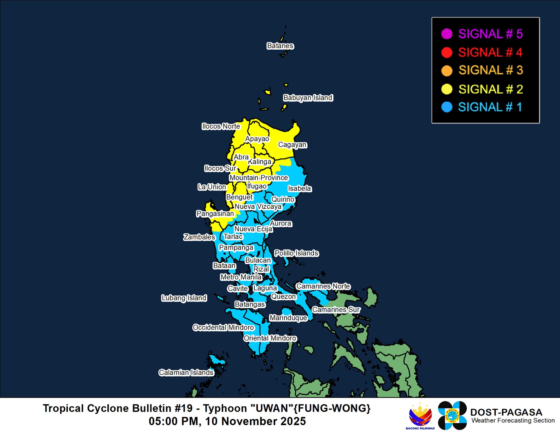 PAGASA wind signal map (click to enlarge)
| Hazards affecting land:
|
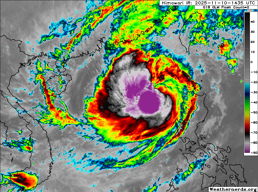
Discussion:
Fung-wong appears to be in the process of trying to reorganize, likely due to a temporary decrease in shear. Convection has quickly rebuilt west and south of the circulation center, and this convection is extremely intense with very cold cloud tops. In spite of this, scatterometer and SAR data indicate that Fung-wong remains rather poorly organized with an elongated circulation, and microwave satellite imagery indicates that Fung-wong’s eyewall is still highly fragmented to the point that it can barely be considered an eye at all. Some persistent mid-level shear is also preventing the convection from wrapping completely around the center to reestablish the eyewall. The intensity is lowered to 70 kts, based on Dvorak estimates ranging from T4.0 to T4.5, a SATCON estimate of 70 kts, and a wide spread of automated estimates ranging from 57 kts to 77 kts.
No major changes have been made to the forecast. Fung-wong should turn northward during the next few hours as it gets steered into a weakness in the subtropical ridge resulting from a frontal boundary digging down from the north. Although Fung-wong is over warm SSTs, it will soon be encountering much stronger shear and cold northeasterly monsoon flow off the Taiwan Strait, and these factors will contribute to additional weakening during the next few days. Fung-wong will likely weaken to a tropical storm by Tuesday evening before making landfall in western Taiwan on Wednesday. Most of the model guidance decays Fung-wong into a trough over Taiwan or just off the eastern coast, and as a result the forecast track indicates dissipation after 72 hours. It is possible the circulation could survive passage over Taiwan, but conditions will likely be so hostile that Fung-wong would likely be a non-convective remnant low by then.
Forecast positions and maximum winds (1-min)
000 hrs: 18.8°N 118.4°E – 70 kts 130 km/h
012 hrs: 19.7°N 118.2°E – 60 kts 110 km/h
024 hrs: 21.0°N 118.3°E – 50 kts 95 km/h
048 hrs: 23.5°N 120.4°E – 35 kts 65 km/h inland
072 hrs: 25.6°N 123.5°E – 25 kts 45 km/h Post-tropical/remnant low
096 hrs: Dissipated
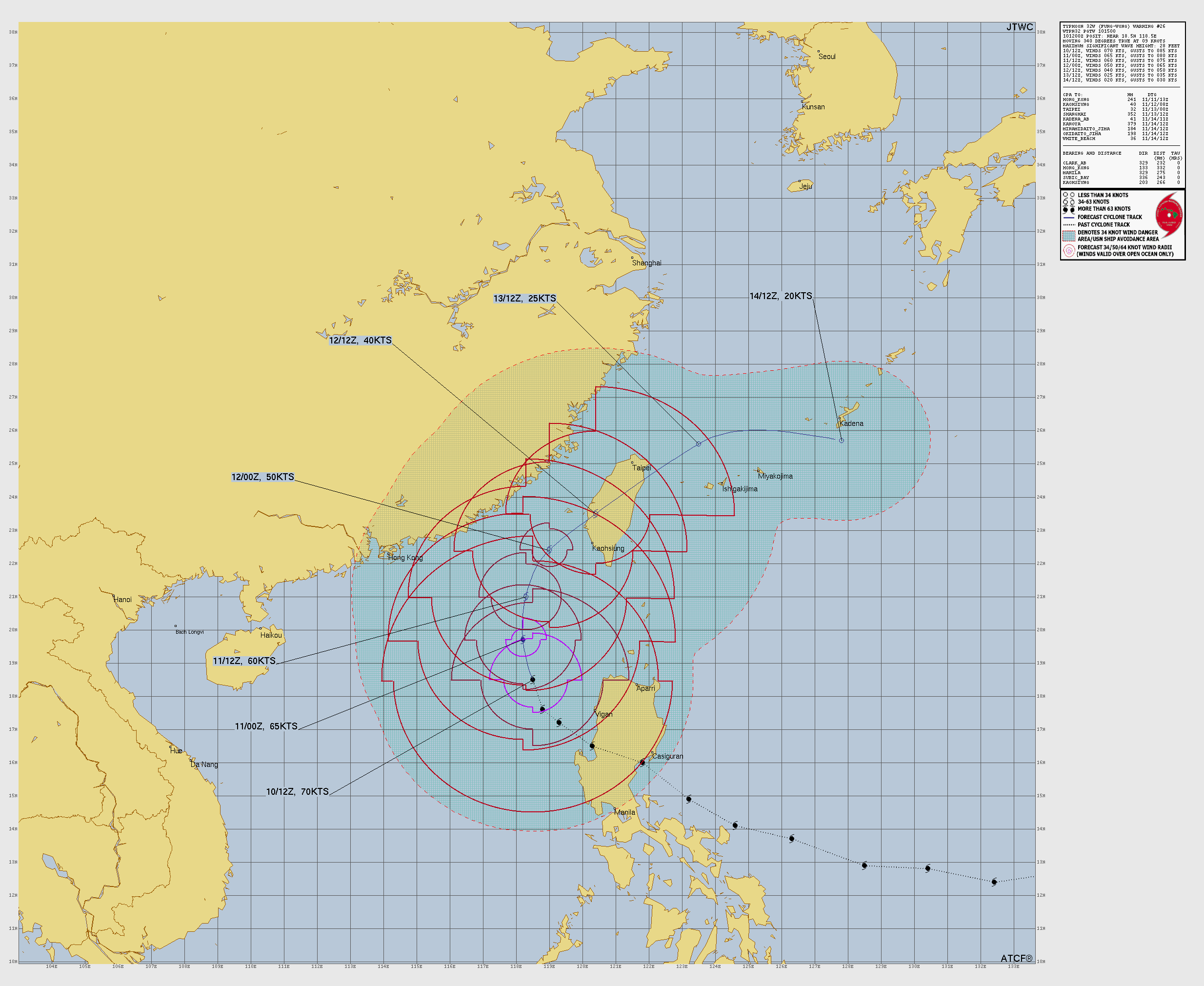
JTWC forecast map
One last thing…
Do you like what you see? Please consider sending a tip via Ko-fi! I wear a lot of hats between a day job, being a photographer, and being a worldwide weather enthusiast, and while I will never put any of my content behind a paywall (paywalls kind of defeat the purpose of this blog/newsletter/thingy), your tips definitely help! You can send a tip via the following link: https://ko-fi.com/willweaverrva