- Will Weaver's Weather & Pacific Typhoon Center
- Posts
- Typhoon Fung-wong (32W/Uwan) – Tropical Cyclone Advisory #14: 0000 UTC 10 November 2025
Typhoon Fung-wong (32W/Uwan) – Tropical Cyclone Advisory #14: 0000 UTC 10 November 2025
Fung-wong moving northwestward off the western coast of Luzon... Typhoon force winds continue along the western coast...
Will Weaver
November 09, 2025
…Fung-wong moving northwestward off the western coast of Luzon… …Typhoon force winds continue along the western coast…
Current storm information:
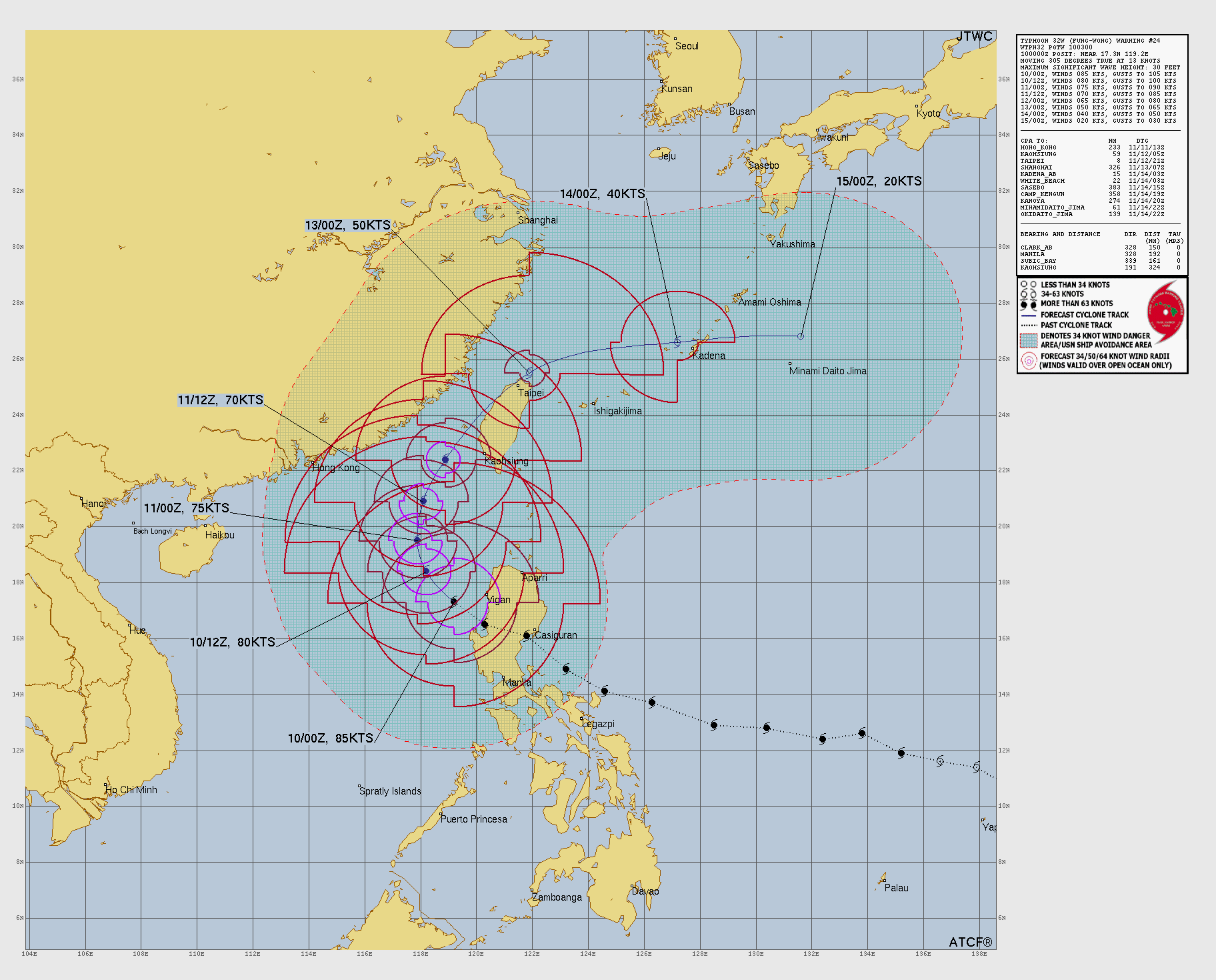
Position: 17.3°N 119.2°E
Movement: NW at 13 knots (25 km/h)
Intensity: 85 knots (155 km/h) [Category 2]
Central pressure: 968 hPa
Trend:
Continued weakening is forecast during the next 24 hours.
Watches and warnings:  PAGASA wind signal map (click to enlarge)
| Hazards affecting land:
|
Discussion:
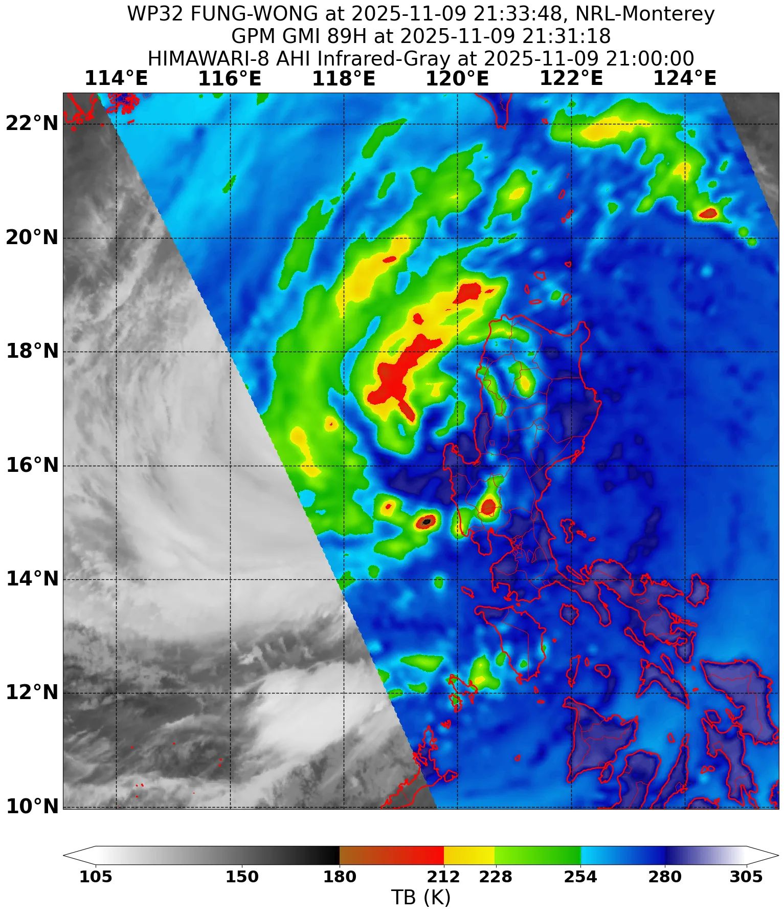
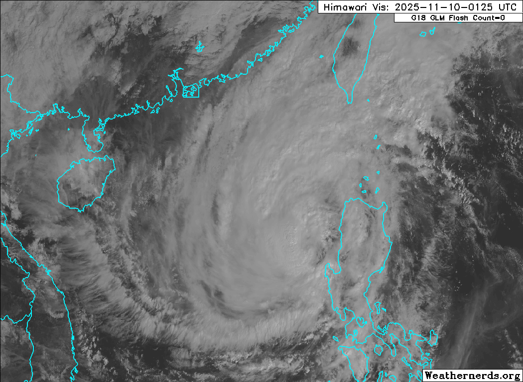
Fung-wong has completed its trek across northern and central Luzon, and stronger shear and land interaction have taken their toll on the typhoon’s structure. The inner core has decreased dramatically in size, and the eye has become irregularly shaped with an opening in the southern and eastern eyewall. The central dense overcast has also become very fragmented, with warming cloud tops in pretty much the entirety of the CDO except for the southwestern quadrant, which is continuing to produce intense convection. The CDO and wind field remain extremely large, with scatterometer data showing 30-kt winds extending almost halfway across the South China Sea. The intensity is lowered to a potentially generous 85 kts, based on Dvorak fixes ranging from T4.5 to T5.0 and hedged between automated estimates ranging from 74 to 90 kts.
Fung-wong has turned toward the northwest as it begins its gradual recurvature into a weakness in the ridge resulting from an upper-level trough over the East China Sea. The cyclone should gradually turn northward and slow down somewhat later today as steering currents weaken. Although Fung-wong is over warm SSTs, moderate to strong shear as well as the cyclone’s current lack of structure will likely preclude any restrengthening. Gradual weakening is likely during the next day or two before Fung-wong begins interacting with the northeast monsoon, which should begin eroding the rest of its convection and cause rapid weakening. The forecast track has been shifted a bit to the west of the previous one and now shows Fung-wong entering the Taiwan Strait before passing over northern Taiwan on Wednesday. Although the JTWC and JMA forecast tracks continue past Taiwan, an increasing amount of the model guidance shows Fung-wong rapidly decaying into a trough just as it moves over the island. Because of this, the forecast below indicates dissipation after 96 hours.
Forecast positions and maximum winds (1-min)
000 hrs: 17.3°N 119.2°E – 85 kts 155 km/h
012 hrs: 18.4°N 118.2°E – 75 kts 140 km/h
024 hrs: 19.5°N 117.9°E – 65 kts 120 km/h
048 hrs: 22.4°N 118.9°E – 55 kts 100 km/h
072 hrs: 25.5°N 121.9°E – 35 kts 65 km/h
096 hrs: 26.6°N 127.2°E – 25 kts 45 km/h Post-tropical/remnant low
120 hrs: Dissipated
JTWC forecast map
One last thing…
Do you like what you see? Please consider sending a tip via Ko-fi! I wear a lot of hats between a day job, being a photographer, and being a worldwide weather enthusiast, and while I will never put any of my content behind a paywall (paywalls kind of defeat the purpose of this blog/newsletter/thingy), your tips definitely help! You can send a tip via the following link: https://ko-fi.com/willweaverrva