- Will Weaver's Weather & Pacific Typhoon Center
- Posts
- Typhoon Danas (05W) - Tropical Cyclone Advisory #5, 0300 UTC 7/6/25
Typhoon Danas (05W) - Tropical Cyclone Advisory #5, 0300 UTC 7/6/25
Danas intensifies into a typhoon, additional typhoon warnings issued for most of the rest of Taiwan
Will Weaver
July 05, 2025
…Danas intensifies into a typhoon… …Additional typhoon warnings issued for most of the rest of Taiwan…
Current storm information:
Position: 21.6°N 118.2°E
Movement: NNE at 5 knots (10 km/h)
Intensity: 70 knots (130 km/h) [Category 1]
Central pressure: 975 hPa
Trend:
Additional strengthening appears likely through tonight, and Danas will likely become a Category 2 typhoon later today. This strengthening will likely level off overnight tonight into Monday.
Watches and warnings:
Typhoon warning (Taiwan): The entire island except for Keelung City, Taipei City, Kinmen County, and Lienchiang County
The No. 1 standby signal is active for Hong Kong and Macau.
Interests in the Batanes Islands should monitor the progress of Danas. Tropical cyclone wind signals could be needed for those islands later today, although Danas is not currently forecast to reenter the PAR.
Hazards affecting land:
Danas is expected to produce extremely heavy rainfall over portions of Taiwan and southeastern China, mostly along the coast of the Taiwan Strait, beginning late tonight into Monday morning. In addition, strong tropical storm or typhoon conditions are possible along those coasts late tonight through Monday evening. Storm total rainfall of over 500 mm is possible in portions of Taiwan through Tuesday.
Heavy monsoonal rainfall is possible in the Batanes Islands and along the northern and western coasts of Luzon on Sunday and Monday. For additional information, including possible warnings, refer to products from your local weather office.
Discussion:
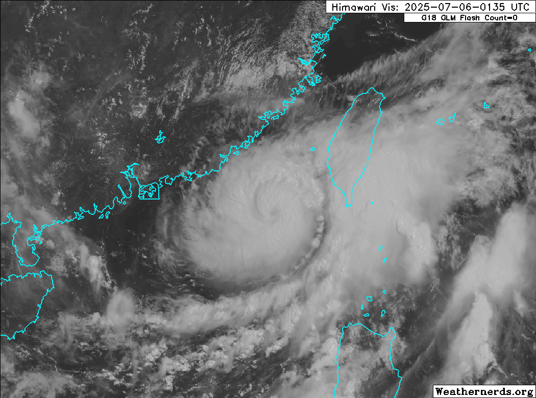
Himawari-9 visible satellite image
Danas appears to be undergoing a rapid intensification phase. The tropical cyclone is quickly clearing out a small eye feature that is becoming increasingly evident on visible satellite imagery. GMI microwave imagery suggests the inner core is quite compact, with convective bands wrapping into a very tight eyewall feature. This eyewall is also easily identifiable on radar imagery from Taiwan, although the eye remains cloud filled and contains areas of light rain. Dvorak estimates have increased quite a bit owing to the improved satellite presentation: KNES and PGTW have fixes of T4.5 to T5.0, while RJTD is lagging behind at T3.5, and some of the automated estimates are low due to the small size of the eye. The intensity is conservatively increased to 70 kts.

Danas has begun accelerating northeastward toward the Taiwan Strait as southwesterly monsoon flow increases, and ridging builds in to the northeast. This general motion is forecast to continue for the next couple of days, and Danas is forecast to pass through the strait tonight into Monday. Low shear and warm waters should allow for additional strengthening, possibly at a rapid rate, and the intensities listed below are higher than the JTWC or JMA forecasts to account for that possibility. By late tonight or early Monday, however, Danas will pass close enough to Taiwan that the mountainous terrain will begin disrupting the cyclone’s structure, and steady to rapid weakening is forecast thereafter.
By Monday evening, steering currents are forecast to collapse as a strong subtropical ridge builds to the north. The model guidance becomes clear as mud once this happens; some of the models have Danas performing a tight loop over the East China Sea, while others - as well as the JMA and JTWC forecasts - have Danas making a hard left and moving inland over eastern China. Confidence in the forecast is low, but regardless of what happens, increasing shear, cooling SSTs, and land interaction will likely contribute to continued weakening, and Danas is expected to dissipate within a developing monsoon gyre by Wednesday.
Forecast positions and maximum winds
00 hrs: 21.6°N 118.2°E – 70 kts
12 hrs: 23.1°N 119.4°E – 90 kts
24 hrs: 25.3°N 120.9°E – 80 kts
48 hrs: 27.8°N 121.8°E – 60 kts
72 hrs: 27.4°N 118.9°E – 45 kts
96 hrs: 26.2°N 115.3°E – 25 kts Post-tropical/remnant low/inland
120 hrs: Dissipated
JTWC forecast map