- Will Weaver's Weather & Pacific Typhoon Center
- Posts
- Tropical Storm Nokaen (01W/Ada) – Tropical Cyclone Advisory #6: 0000 UTC 16 January 2026
Tropical Storm Nokaen (01W/Ada) – Tropical Cyclone Advisory #6: 0000 UTC 16 January 2026
Nokaen continues to move northward east of the Philippines...
Will Weaver
January 15, 2026
…Nokaen continues to move northward east of the Philippines…
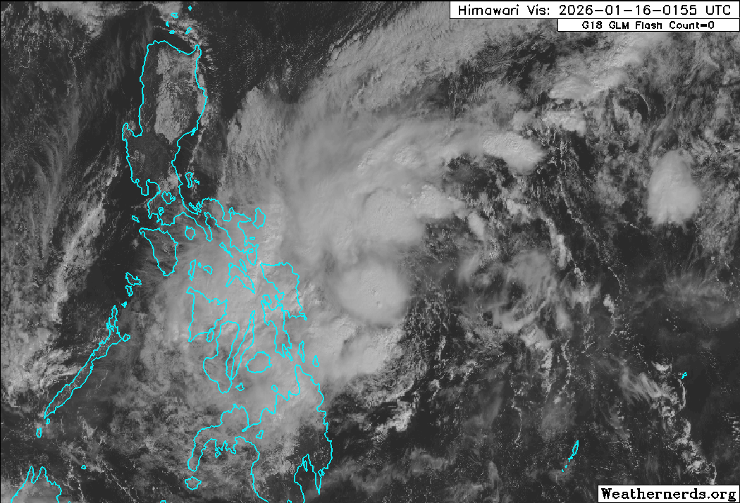
Himawari-9 visible satellite image (Weathernerds)
Current storm information:
Position: 11.2°N 128.9°E
Movement: N at 8 knots (15 km/h)
Intensity: 35 knots (65 km/h)
Central pressure: 999 hPa
Trend:
Little change in strength is forecast during the next 24 hours.
Watches and warnings:  PAGASA wind signal map (click to enlarge)
Areas that should monitor this system: This section is new for 2026 – not every agency issues local tropical cyclone watches or warnings. This is a general list of land areas that should monitor the progress of this system and plan accordingly, whether or not official tropical cyclone watches or warnings are in effect.
| Hazards affecting land:
|
Discussion:

Himawari-9 infrared satellite image (Weathernerds)
Nokaen is not a well organized tropical storm. Persistent easterly shear is inhibiting its efforts to generate persistent convection near its circulation center, and the center was fully exposed until about an hour ago. Despite the shear, the convection continues to be organized into ragged bands, with more clustered convection near and to the west of the center with very cold cloud tops. The convection also continues to sport strong poleward outflow due to the strong subtropical jet parked to the north. Dvorak estimates continue to range from T2.0 to T2.5 and CIMSS ADT and D-PRINT estimates still support a borderline tropical storm, so the intensity is held at 35 kts.
The forecast is mostly unchanged from the previous one. The ridge over Vietnam has weakened considerably, and this has allowed the one near the Marianas to become the primary steering mechanism for Nokaen. As a result, Nokaen should continue moving slowly and erratically toward the north or northwest during the next 2 to 3 days before turning northward into a weakness in the ridge. No major changes in strength appear likely during that time as persistent easterly shear and an increasingly dry air mass, as well as cooling SSTs, should preclude any major strengthening. The HWRF and HAFS-A models inexplicably make Nokaen a typhoon within 48 hours, which does not appear even remotely likely.
By Sunday, the subtropical ridge is expected to build westward and block Nokaen from going any further northward. The forecast track has been adjusted slightly to show a tighter loop through the end of the forecast period as much of the guidance, including Google DeepMind, is now suggesting a tighter loop well to the east of Luzon. While Nokaen is making this loop, the environment should become much more January-like, with prohibitively strong shear and very dry air causing rapid weakening. Although Nokaen will likely begin to loop back toward the Philippines at hour 120, nearly all of the model guidance dissipates its circulation by then, or shortly after.
Forecast positions and maximum winds (1-min)
000 hrs: 11.2°N 128.9°E – 35 kts 65 km/h
012 hrs: 12.2°N 127.9°E – 35 kts 65 km/h
024 hrs: 13.2°N 126.9°E – 35 kts 65 km/h
048 hrs: 14.9°N 125.9°E – 35 kts 65 km/h
072 hrs: 15.8°N 126.7°E – 35 kts 65 km/h
096 hrs: 15.9°N 127.9°E – 30 kts 55 km/h
120 hrs: 14.7°N 129.3°E – 25 kts 45 km/h

JTWC forecast map