- Will Weaver's Weather & Pacific Typhoon Center
- Posts
- Tropical Storm Krosa (12W) – Tropical Cyclone Advisory #3: 1200 UTC 24 July 2025
Tropical Storm Krosa (12W) – Tropical Cyclone Advisory #3: 1200 UTC 24 July 2025
Despite intense wind shear, Tropical Depression 12W strengthens into Tropical Storm Krosa.
Will Weaver
July 24, 2025
…Despite intense wind shear, Tropical Depression 12W strengthens into Tropical Storm Krosa…
 Himawari-9 infrared satellite image (Weathernerds) | Current storm information:
Trend:
|
Watches and warnings:
| Hazards affecting land:
|
Discussion:

Himawari-9 infrared satellite image (Weathernerds)
Despite being continuously blasted by 30 to 40 knots of northwesterly shear, Tropical Depression 12W has proven to be a very tenacious little system. Satellite imagery and scatterometer data indicates that it has a well defined surface circulation which is continuing to generate intense convection, although that convection is being sheared almost due south of the center. In addition, multiple ASCAT passes indicate that the system is producing winds of 30 to 35 knots mainly south and east of the center. Although Dvorak estimates are predictably low owing to the severely sheared nature of the system, the scatterometer data and CIMSS ADT and AiDT estimates are enough to upgrade 12W to a tropical storm, and JMA has upgraded it to Tropical Storm Krosa with 35 kt winds.

F-17 SSMIS 91GHz microwave image
Krosa is expected to move generally northward under the influence of a strong subtropical ridge parked over the Central Pacific. It will likely be hanging on for dear life for another day or so before the large monsoonal system in the East China and Philippine Seas weakens and breaks down, which will reduce the shear affecting Krosa and allow for some strengthening. Most of the model guidance brings Krosa near typhoon strength by Monday, before the shear increases again and Krosa encounters a drier air mass. Krosa is also forecast to slow down near the end of the forecast period as steering currents break down and a large monsoon trough becomes established across the subtropical Pacific. Some of the long-term model solutions indicate that Krosa could be around for a long, long time, although it will likely not be a direct threat to land after the next couple of days.
Forecast positions and maximum winds
00 hrs: 15.6°N 143.0°E – 35 kts
12 hrs: 17.4°N 143.7°E – 35 kts
24 hrs: 18.3°N 144.0°E – 40 kts
48 hrs: 20.7°N 145.0°E – 50 kts
72 hrs: 24.5°N 145.6°E – 60 kts
96 hrs: 28.1°N 144.9°E – 55 kts
120 hrs: 29.5°N 144.7°E – 50 kts
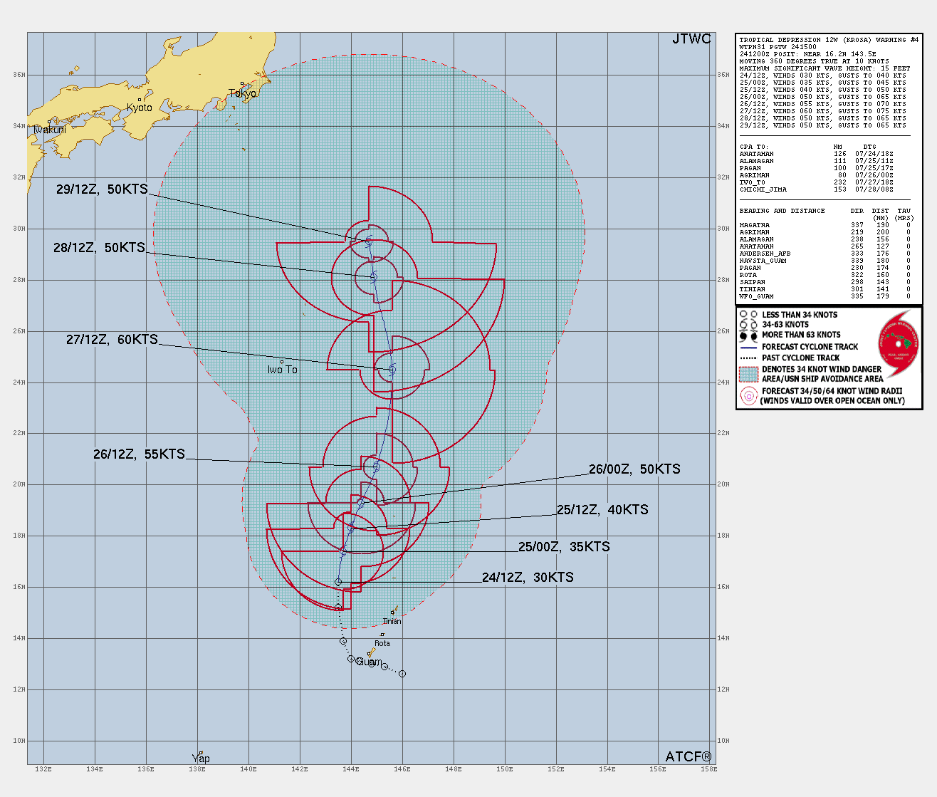
JTWC forecast map