- Will Weaver's Weather & Pacific Typhoon Center
- Posts
- Tropical Storm Danas (05W) - Tropical Cyclone Advisory #9: 1200 UTC 8 July 2025
Tropical Storm Danas (05W) - Tropical Cyclone Advisory #9: 1200 UTC 8 July 2025
Danas making landfall near Wenzhou in Eastern China
Will Weaver
July 08, 2025
…Danas making landfall near Wenzhou in Eastern China…
Current storm information:
Position: 27.8°N 121.5°E
Movement: WSW at 5 knots (10 km/h)
Intensity: 35 knots (65 km/h)
Central pressure: 996 hPa
Trend:
Danas is forecast to weaken during the next 24 hours, and the system could dissipate on Wednesday.
Watches and warnings:
There are no land-based watches or warnings in effect.
Hazards affecting land:
Danas (and its remnants) is expected to produce widespread heavy rainfall over portions of southeastern China and Taiwan during the next several days. This rainfall will likely cause widespread severe flooding. For additional information and possible warnings, refer to products from your local weather office.
Discussion:

Himawari-9 infrared satellite image of Danas (Weathernerds)
Satellite and radar data indicates that Danas is in the process of making landfall in Eastern China just to the northeast of Wenzhou. The tropical storm is very poorly organized, and it may no longer have a closed circulation - scatterometer data from ASCAT and HYSAT suggest that the circulation has become sharply elongated and resembles a trough. Convective banding appears to be breaking down, and Danas consists of a large, intense convective overcast feature with little in the way of structure. Given the breakdown of Danas’s structure and the general lack of tropical storm force winds observed by the scatterometers, the intensity is lowered to 35 kts, slightly below an average of T2.5 to T3.0 Dvorak fixes and about on par with a CIMSS ADT estimate of 34 kts.

Composite radar image (CyclonicWx)
Danas is forecast to begin a rather tight loop to the southwest under the influence of a developing monsoon gyre. Although Danas will likely remain fairly near the coast during this process, its already poorly organized circulation probably won’t last very long, and it will likely open up into a trough within the monsoonal flow on Wednesday. Although much of the model guidance brings the remnants of Danas back out over water later this week, environmental conditions will not be conducive for redevelopment.
Forecast positions and maximum winds
00 hrs: 27.8°N 121.5°E – 35 kts
12 hrs: 27.2°N 119.7°E – 30 kts inland
24 hrs: 26.4°N 117.6°E – 25 kts inland
48 hrs: Dissipated
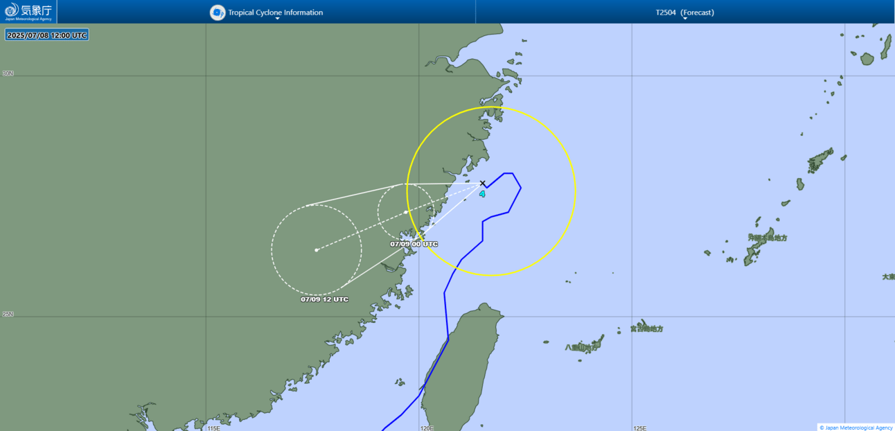
JMA forecast map