- Will Weaver's Weather & Pacific Typhoon Center
- Posts
- Tropical Storm Danas (05W) - Tropical Cyclone Advisory #4, 1500 UTC 7/5/25
Tropical Storm Danas (05W) - Tropical Cyclone Advisory #4, 1500 UTC 7/5/25
Danas strengthening quickly and approaching typhoon strength, typhoon warnings issued for parts of Taiwan
Will Weaver
July 05, 2025
…Danas strengthening quickly and approaching typhoon strength… …Typhoon warnings issued for parts of Taiwan…
Current storm information:
Position: 20.8°N 117.9°E
Movement: NNE at 3 knots (5 km/h)
Intensity: 60 knots (110 km/h)
Central pressure: 982 hPa
Trend:
Steady strengthening is expected during the next 24 hours, and Danas is expected to become a typhoon later tonight.
Watches and warnings:
The No. 1 standby signal is active for Hong Kong and Macau.
Typhoon warning (Taiwan): Chiayi City, Chiayi County, Tainan, Kaohsiung, Pingtung County, Penghu County
Interests in the Batanes Islands should monitor the progress of Danas. Tropical cyclone wind signals could be needed for those islands on Sunday, although Danas is not forecast to reenter the PAR.
Hazards affecting land:
Danas is expected to produce extremely heavy rainfall over portions of Taiwan and southeastern China, mostly along the coast of the Taiwan Strait. In addition, strong tropical storm or typhoon conditions are possible along those coasts on Sunday and Monday. Storm total rainfall of over 500 mm is possible in portions of Taiwan through Tuesday.
Heavy monsoonal rainfall is possible in the Batanes Islands and along the northern and western coasts of Luzon on Sunday and Monday. For additional information, including possible warnings, refer to products from your local weather office.
Discussion:

Himawari-9 infrared satellite image
Danas is very close to typhoon intensity. Although the central dense overcast has become somewhat more compact, cloud tops within the CDO have continued to cool, and an eye feature is becoming apparent on both satellite and composite radar imagery. In addition, the CDO itself has become more symmetric, owing to decreasing shear. Danas is exhibiting impressive radial outflow thanks to venting from the monsoon trough to the south and a TUTT cell located to the northeast. Dvorak fixes range from T3.5 to T4.5, while CIMSS ADT and D-PRINT estimate 55 and 59 kts respectively. Taking a blend of these estimates yields an intensity of 60 kts.

Composite radar image
There are no changes to the forecast. Danas is forecast to accelerate northeastward as the TUTT cell northeast of Taiwan fills and dissipates, allowing upper-level ridging to build westward. The environment appears to be conducive for rapid intensification, and CIMSS AI-RI and RIPA guidance suggests high probabilities of short- and long-term RI (46.3% chance of an increase of 25 kts in the next 24 hrs, 31.3% chance of an increase of 45 kts in 36 hrs). Given the favorable environment, Danas is likely to become a typhoon within the next 12 hours, and the JTWC and JMA forecasts may be conservative - therefore, the intensities listed below are higher than those forecasts. Danas should peak in intensity on Monday before increasing shear and interaction with the Taiwan and China landmasses results in some weakening. On Tuesday, a rapidly weakening Danas should run headlong into a strong ridge over the East China Sea and turn sharply westward, making landfall in eastern China early Wednesday. Danas should rapidly decay as it moves inland, and it will likely dissipate later on Wednesday.
Forecast positions and maximum winds
00 hrs: 20.8°N 117.9°E – 60 kts
12 hrs: 21.8°N 118.5°E – 80 kts
24 hrs: 23.2°N 119.4°E – 95 kts
48 hrs: 26.5°N 121.5°E – 75 kts
72 hrs: 27.5°N 120.2°E – 45 kts inland
96 hrs: 27.1°N 117.1°E – 25 kts Post-tropical/remnant low
120 hrs: Dissipated
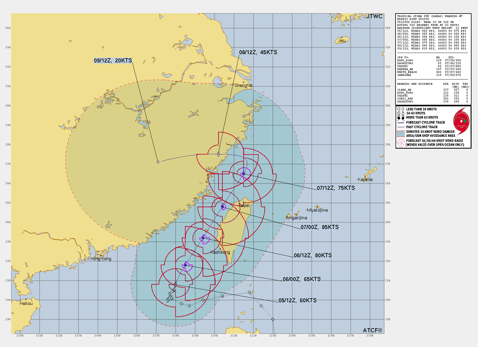
JTWC forecast map