- Will Weaver's Weather & Pacific Typhoon Center
- Posts
- Tropical Storm 16W – Tropical Cyclone Advisory #2: 1200 UTC 7 August 2025
Tropical Storm 16W – Tropical Cyclone Advisory #2: 1200 UTC 7 August 2025
Depression strengthens into a tropical storm as it begins moving slowly west-northwestward. Could become a very intense system during the next few days.
Will Weaver
August 07, 2025
…Depression strengthens into a tropical storm as it begins moving slowly west-northwestward… …Could become a very intense system during the next few days…
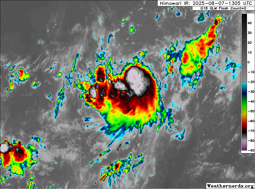
Himawari-9 infrared satellite image (Weathernerds)
Current storm information:
Position: 19.0°N 147.0°E
Movement: WNW at 4 knots (5 km/h)
Intensity: 35 knots (65 km/h)
Central pressure: 1004 hPa
Trend:
Steady strengthening is expected during the next 24 hours.
Watches and warnings:
| Hazards affecting land:
|
Discussion:
Tropical Depression 16W has moved out of the northeasterly subsidence that had been affecting it around the time of the previous advisory, and the tropical cyclone’s structure seems to be responding accordingly. Although most of the convection remains lopsided to the south and west of the circulation center, the center is no longer exposed and is tucked underneath the northeastern edge of the convective mass. Microwave satellite imagery suggests that banding is beginning to develop and wrap into the center from the south. The system remains quite compact, so it’s difficult to get a good read on its wind field through scatterometer data, but Dvorak fixes of T2.0 to T2.5 from KNES, PGTW, and RJTD and automated CIMSS ADT, D-PRINT, and SATCON estimates of 34, 33, and 37 kts respectively all suggest the system has become a tropical storm. The intensity is increased to 35 kts based on a blend of these data.

METOP-B MHS 89GHz microwave satellite image (RAMMB/CIRA)
The forecast is generally unchanged from the previous one, with the exception of the intensity. CIMSS layer mean wind analysis indicates that a developing subtropical ridge moving east over the Ryukyu Islands is gradually making its way toward TS 16W. Once it does, the storm should gradually turn almost due west, and this due west motion is forecast to continue more or less through the end of the forecast period. There is a bit of spread among the model tracks, showing tracks ranging from south of Taiwan to near Okinawa. In addition, the GFS model nudges 16W a bit to the west-southwest in the middle portion of the forecast period, but resumes a west-northwestward motion toward the end of it. All of this means that early indications are that this system will likely remain north or northeast of the Philippines. As the basin is in a suppressed phase of the MJO and the monsoon trough is inactive, it does not seem likely that enhanced monsoonal rainfall will be much of an issue.
The intensity forecast has been adjusted significantly upward. 16W is forecast to remain a rather compact system during the next several days, and compact systems tend to be very sensitive to environmental changes. All indications are that the environment should remain quite favorable for strengthening during the next few days with low shear, very warm SSTs, and favorable poleward outflow. The HWRF and HAFS models, as well as the CIMSS AI-RI and RAMMB RIPA rapid intensification indices, all indicate a high likelihood of rapid intensification beginning on Saturday as the system crosses the Philippine Sea. 16W is forecast to become a typhoon on Saturday, and it could be a very intense system as the forecast period ends. The winds below are, again, higher than the most recent JTWC and JMA forecasts have indicated. JMA notably struggles with very small systems.
Forecast positions and maximum winds
00 hrs: 19.0°N 147.0°E – 35 kts
12 hrs: 19.9°N 146.0°E – 45 kts
24 hrs: 21.1°N 144.2°E – 55 kts
48 hrs: 21.7°N 141.0°E – 70 kts
72 hrs: 22.0°N 136.2°E – 90 kts
96 hrs: 22.0°N 131.7°E – 105 kts
120 hrs: 22.0°N 126.4°E – 120 kts

Forecast map (based on 12Z JMA forecast track)