- Will Weaver's Weather & Pacific Typhoon Center
- Posts
- Tropical Depression Senyar (34W, formerly 04B) – Tropical Cyclone Advisory #4: 0000 UTC 29 November 2025
Tropical Depression Senyar (34W, formerly 04B) – Tropical Cyclone Advisory #4: 0000 UTC 29 November 2025
Senyar running out of time to intensify...
Will Weaver
November 28, 2025
…Senyar running out of time to intensify…

Replace this image with a current satellite image of the storm (Source)
Current storm information:
Position: 5.3°N 106.3°E
Movement: ENE at 9 knots (15 km/h)
Intensity: 30 knots (55 km/h)
Central pressure: 1002 hPa
Trend:
Little change in strength is forecast during the next 24 hours, but Senyar could briefly become a tropical storm again later today.
Watches and warnings:
| Hazards affecting land:
|
Discussion:

JTWC has reclassified Senyar from 04B to 34W. It is unclear if JMA would assign a new name to this system if they upgrade it to tropical storm status.
Senyar has lost some organization since the previous advisory. After managing to develop a partial eye-like feature earlier, a burst of easterly shear has wiped out much of Senyar’s convective structure. The tropical depression consists of almost linear bands of convection shearing off to the west of a partially exposed and very tiny circulation center. The circulation is so small that it’s barely resolvable on scatterometer data, but most of the available intensity estimates suggest the intensity remains 30 kts.
Senyar is running out of time. The strong easterly shear is forecast to persist as it moves generally northeastward within wind flow associated with Koto to the northeast. Senyar has a brief window of opportunity to intensify a little later today before the shear becomes overwhelming. By Sunday, much stronger shear and dry air filtering in from the northeast should make quick work of Senyar’s tiny circulation, and the system will likely dissipate outright by Monday. In the event it manages to survive, it will likely merge with Koto’s larger circulation on Monday evening.
Forecast positions and maximum winds
000 hrs: 5.3°N 106.3°E – 30 kts 55 km/h
012 hrs: 6.1°N 107.4°E – 35 kts 65 km/h
024 hrs: 7.8°N 109.2°E – 25 kts 45 km/h
048 hrs: Dissipated
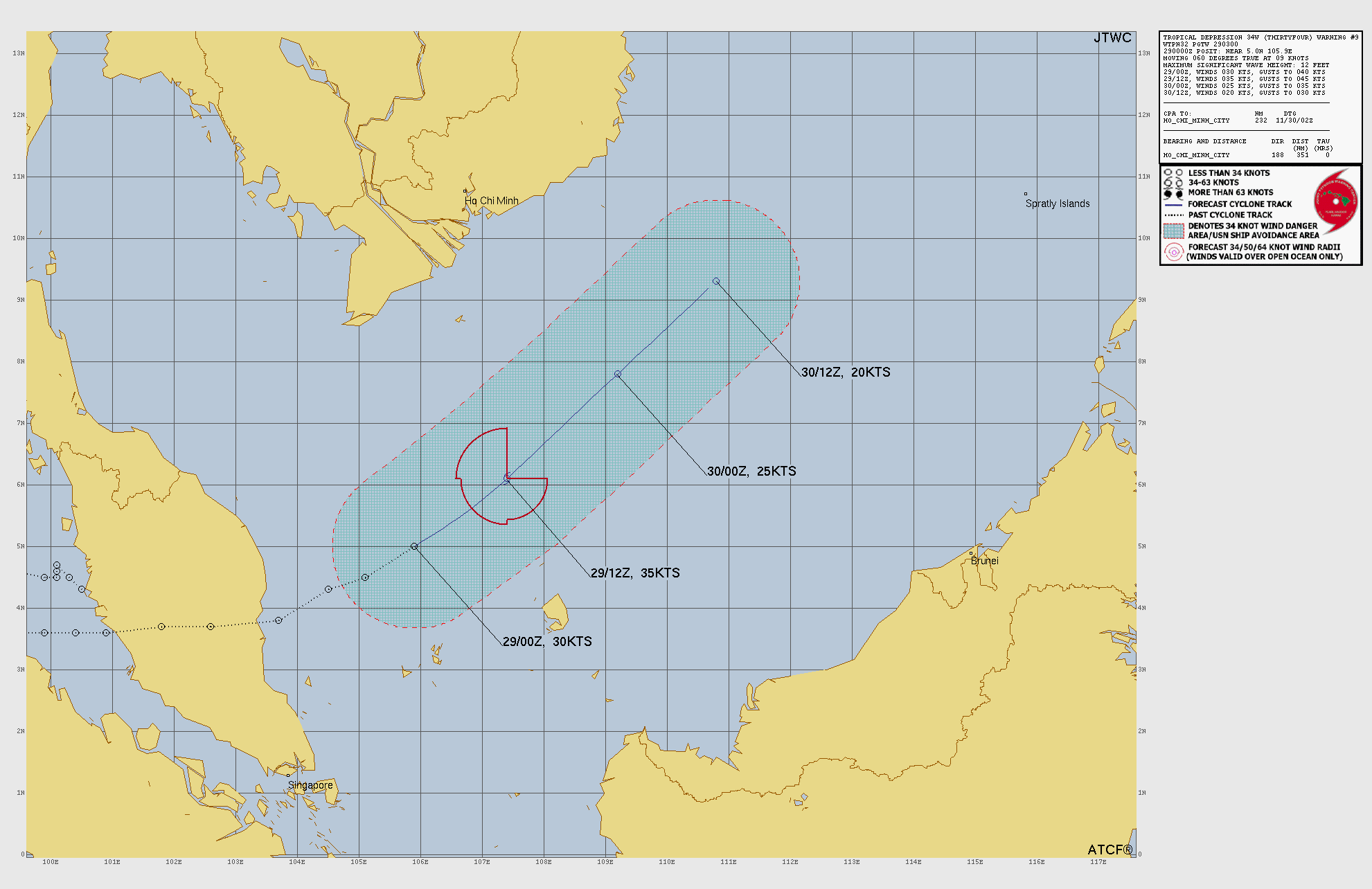
JTWC forecast map