- Will Weaver's Weather & Pacific Typhoon Center
- Posts
- Tropical Depression (Invest 96W / RamilPH) – Tropical Cyclone Advisory #1: 1800 UTC 16 October 2025
Tropical Depression (Invest 96W / RamilPH) – Tropical Cyclone Advisory #1: 1800 UTC 16 October 2025
Tropical depression forms well to the east of the Philippines... Likely to bring heavy rainfall to portions of Luzon over the weekend...
Will Weaver
October 16, 2025
…Tropical depression forms well to the east of the Philippines… …Likely to bring heavy rainfall to portions of Luzon over the weekend…

Himawari-8 infrared satellite image (Weathernerds)
Current storm information:
Position: 13.7°N 132.6°E
Movement: W at 10 knots (20 km/h)
Intensity: 30 knots (55 km/h)
Central pressure: 1004 hPa
Trend:
Some slow strengthening is possible during the next 24 hours and the depression could become a tropical storm by Saturday.
Watches and warnings:
| Hazards affecting land:
|
Discussion:
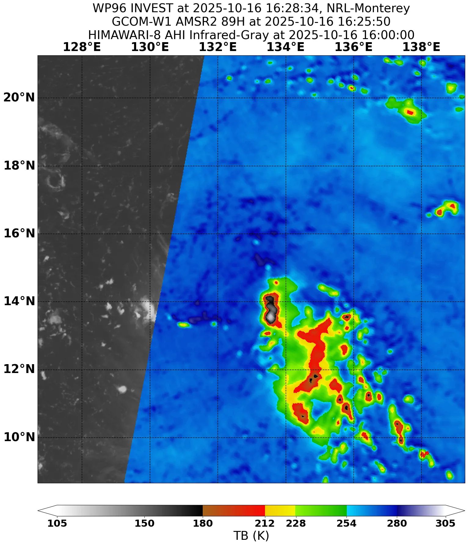
GCOM-W1 AMSR2 89GHz microwave satellite image
The disturbance in the Philippine Sea has shown signs of becoming better organized. Although the most recent scatterometer data indicates that the system appears to resemble a sharp trough rather than a closed low pressure area, satellite imagery suggests that a closed circulation has formed, tucked under the northwestern edge of an area of increasingly well organized convection. This convection is also forming into rudimentary bands, although it is mostly displaced to the southeast of the center. Therefore, it appears the disturbance has attained enough organization to be considered a tropical depression. The initial intensity is set to 30 kts, based on the earlier scatterometer data and Dvorak fixes of T1.5 to T2.0 from KNES and RJTD.
The depression is not in a particularly favorable environment, with moderate (20 to 25 kts) west-northwesterly shear associated with a very strong mid- to upper-level ridge anchored north of Taiwan and a weaker mid-level near-equatorial ridge anchored over Mindanao. This shear is not expected to abate any time soon, and so despite very warm SSTs, TD 96W appears likely to strengthen only very gradually during the next couple of days before reaching the Philippines. The depression will likely still become a tropical storm late Friday or early Saturday as it moves generally west-northwestward under the influence of the stronger ridge to the north, with a sharp turn toward the northwest expected just before landfall as a trough digs down from the northern portion of the East China Sea. A continued northwestward motion is expected after landfall, before strong northeasterly surface flow off the Taiwan Strait associated with a gap wind event nudges the system to the west-southwest as it enters the South China Sea. Some more substantial strengthening appears likely on Monday and Tuesday as the environment should be much more conducive in that region. There is fairly good confidence in the forecast track, which is south of the operational GFS and closer to the GFS, ECMWF, and Google DeepMind ensembles.
Forecast positions and maximum winds
000 hrs: 13.7°N 132.6°E – 30 kts
012 hrs: 13.7°N 130.5°E – 30 kts
024 hrs: 13.6°N 126.9°E – 35 kts
048 hrs: 15.2°N 123.8°E – 35 kts
072 hrs: 17.4°N 118.3°E – 40 kts
096 hrs: 18.1°N 115.9°E – 45 kts
120 hrs: 17.9°N 113.8°E – 50 kts
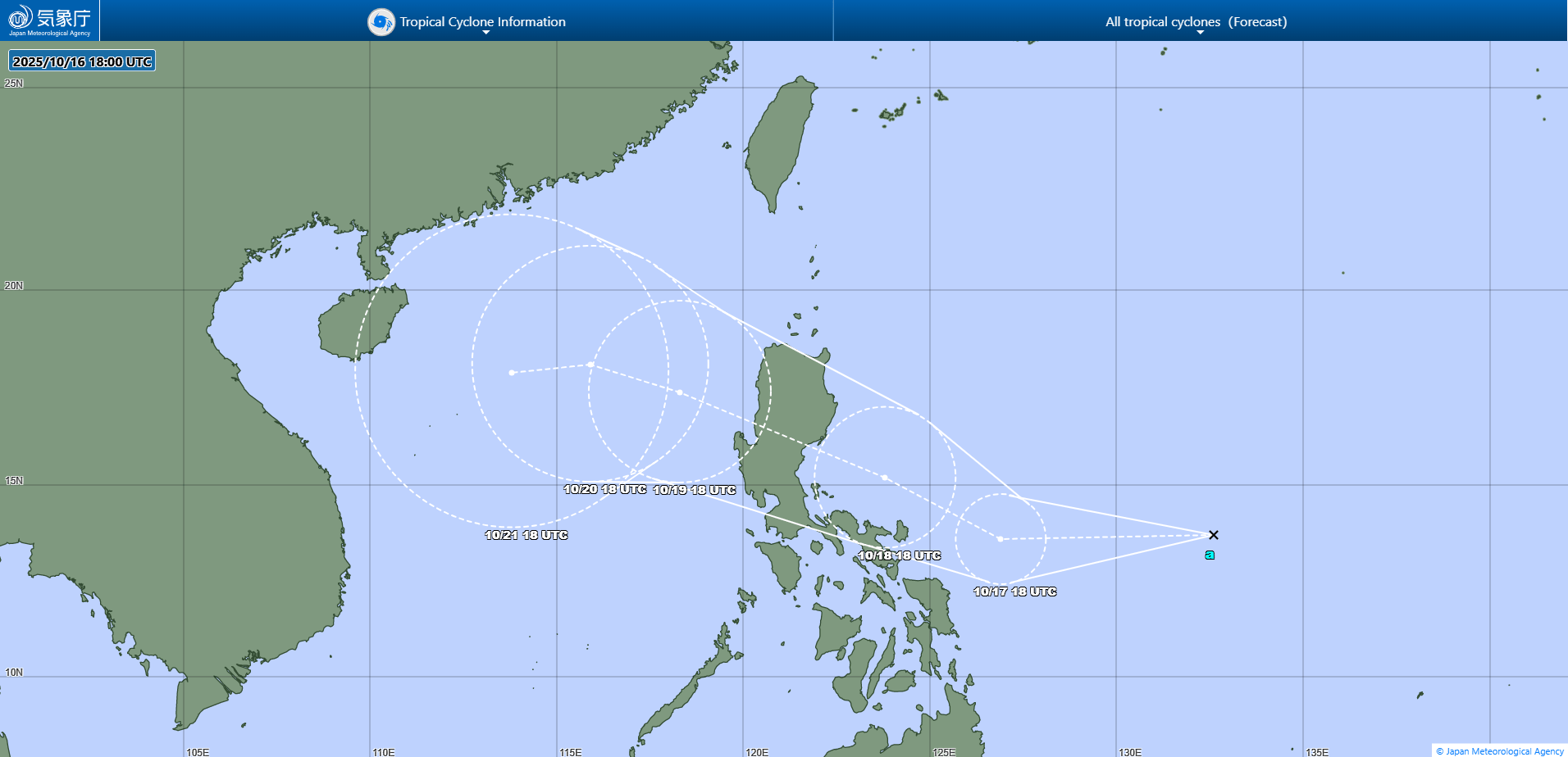
JMA forecast map