- Will Weaver's Weather & Pacific Typhoon Center
- Posts
- Tropical Depression (Invest 94W / Basyang) – Tropical Cyclone Advisory #1: 1200 UTC 3 February 2026
Tropical Depression (Invest 94W / Basyang) – Tropical Cyclone Advisory #1: 1200 UTC 3 February 2026
Another wintertime tropical depression forms north of Palau, could become a short-lived tropical storm before reaching the Philippines.
Will Weaver
February 03, 2026
…Another wintertime tropical depression forms north of Palau… …Could become a short-lived tropical storm before reaching the Philippines…

Himawari-9 infrared satellite image (Weathernerds)
Current storm information:
Position: 09.6°N 134.5°E
Movement: WNW at 10 knots (20 km/h)
Intensity: 30 knots (65 km/h)
Central pressure: 1004 hPa
Trend:
Some gradual strengthening is forecast during the next 24 hours, and the depression could become a tropical storm on Wednesday evening.
Watches and warnings:
Areas that should monitor this system:
| Hazards affecting land:
|
Discussion:
The low pressure area now located north of Koror has gotten its act together quite quickly during the past 24 hours or so. Scatterometer data from HYSAT and Oceansat indicate that the system has developed a well-defined closed surface circulation center, although the strongest winds associated with the system (about 25 to 30 kts) are located in the northwestern quadrant. This is likely due to interaction with a shear line to the north. Most of the convection is also located north and west of the center, although there are bands located further from the center to the south and east. As is typical for mid-winter tropical systems, there is fairly strong poleward outflow courtesy of a very strong subtropical jet streak. This system has received Dvorak estimates of T1.5 to T2.0 from KNES and RJTD, and as such it has been classified as a warning-status tropical depression by JMA and locally named Basyang by PAGASA.
Although the depression looks to be getting better organized, it is early February, and as is typical for early February, the environment is not expected to be particularly conducive for strengthening. TD 94W is currently located in a small pocket of slightly reduced shear, but is surrounded by a rather dry mid-level air mass. The environment is expected to remain only marginally favorable during the next few days, and therefore only some gradual strengthening is likely before 94W reaches Mindanao late Thursday night. TD 94W is likely to become a tropical storm before making landfall. Following landfall, the shear is expected to increase dramatically as 94W turns northwestward into a weakness in the subtropical ridge. As 94W gains latitude, the shear will become overwhelmingly strong, and most of the model guidance dissipates 94W’s circulation over the Central Visayas on Sunday.
It should be noted that while the global models and the Google DeepMind ensemble indicate dissipation, the HAFS-A and HWRF models not only show 94W surviving longer, they also indicate much more intensification than indicated in the forecast. These are being considered outliers at this time.
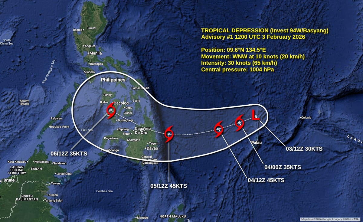
Forecast map
Forecast positions and maximum winds (1-min)
000 hrs: 09.6°N 134.5°E – 30 kts 55 km/h
012 hrs: 09.1°N 133.2°E – 35 kts 65 km/h
024 hrs: 08.6°N 131.5°E – 45 kts 85 km/h
048 hrs: 08.2°N 127.5°E – 45 kts 85 km/h
072 hrs: 10.1°N 122.8°E – 35 kts 65 km/h
096 hrs: Dissipated
Please support my work by leaving a tip!
Please consider sending a tip via Ko-fi! I wear a lot of hats between a day job, being a photographer, and being a worldwide weather enthusiast, and while I will never put any of my content behind a paywall, your tips definitely help! You can send a tip via the following link: https://ko-fi.com/willweaverrva