- Will Weaver's Weather & Pacific Typhoon Center
- Posts
- Tropical Depression (Invest 91W) - Special Tropical Cyclone Advisory #1 1800 UTC 13 January 2026
Tropical Depression (Invest 91W) - Special Tropical Cyclone Advisory #1 1800 UTC 13 January 2026
The 2026 Pacific typhoon season gets off to an early start with a tropical depression east of the Philippines.
Will Weaver
January 13, 2026
…The 2026 Pacific typhoon season gets off to an early start with a tropical depression east of the Philippines…
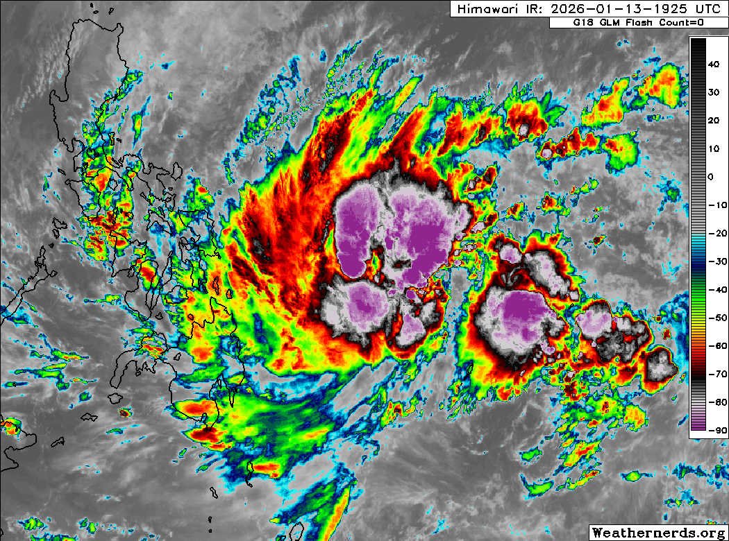
Himawari-9 infrared satellite image (Weathernerds)
Current storm information:
Position: 8.8°N 131.7°E
Movement: NW at 5 knots (10 km/h)
Intensity: 30 knots (55 km/h)
Central pressure: 1004 hPa
Trend:
Some strengthening is forecast during the next 24 hours, and the depression could become a tropical storm late tonight or on Thursday.
Watches and warnings:
Areas that should monitor this system: This section is new for 2026 – not every agency issues local tropical cyclone watches or warnings. This is a general list of land areas that should monitor the progress of this system and plan accordingly, whether or not official tropical cyclone watches or warnings are in effect.
| Hazards affecting land:
|
Discussion:

1412 UTC Oceansat-3 scatterometer image, indicating a closed circulation
A westerly wind burst event, a hallmark of developing El Niño events, has traversed the equatorial Pacific, and has triggered the formation of some low pressure areas. The one southwest of Palau has quickly generated a large area of intense convection, and scatterometer imagery from Oceansat and HYSAT indicate that the low’s circulation has become better defined during the past several hours. In addition, CIMSS shear and upper-level wind analysis indicates that a small anticyclone is forming over the system, which is blocking the effects of strong shear over the region. Given the organization of the convection and scatterometer data indicating the presence of 25 to 30 kt winds, this low has achieved enough organization to be classified as a tropical depression by JMA. This depression is the first warning-status system to exist in the Western Pacific basin in January since 2019’s Tropical Storm Pabuk.
Although the environment appears to be modestly favorable - shear is relatively low, SSTs are warm at 29-30°C, and there is a decent amount of mid-level moisture, it is still January. Steering currents are relatively weak, with the dominant steering feature being a mid-level ridge located well to the east of the Marianas and a frontal boundary digging down from the north. This combination of features should cause 91W to move generally northwestward during the next couple of days, before turning northward while remaining east of the Philippines. As the system gains latitude, it will move into an increasingly dry air mass. TD 91W will likely become a tropical storm during the next 24 hours or so, but it will likely peak at 40 to 45 kts by Friday. By this weekend, the frontal system to the north is expected to move out, which will cause ridging to build back in and trap 91W in an area of weak steering currents. 91W will likely be meandering and weakening by the end of the forecast period as it turns northeastward and possibly loops to the southeast, as shear is expected to increase rapidly as the ridge builds back in.
While the current forecast keeps the center of 91W away from any land areas, the system’s large size will likely result in heavy rainfall over Koror and portions of coastal Samar, Leyte, Catanduanes, and northeastern Mindanao through the end of the week.
Forecast positions and maximum winds (1-min)
000 hrs: 08.8°N 131.7°E – 30 kts 55 km/h
012 hrs: 09.0°N 131.0°E – 30 kts 55 km/h
024 hrs: 09.4°N 130.0°E – 35 kts 65 km/h
048 hrs: 10.8°N 128.1°E – 40 kts 75 km/h
072 hrs: 12.6°N 126.5°E – 45 kts 85 km/h
096 hrs: 13.9°N 125.6°E – 45 kts 85 km/h
120 hrs: 15.8°N 126.0°E – 40 kts 75 km/h

Forecast map
Please support my work by leaving a tip!
Please consider sending a tip via Ko-fi! I wear a lot of hats between a day job, being a photographer, and being a worldwide weather enthusiast, and while I will never put any of my content behind a paywall, your tips definitely help! You can send a tip via the following link: https://ko-fi.com/willweaverrva