- Will Weaver's Weather & Pacific Typhoon Center
- Posts
- Tropical Depression 01W (Ada) – Tropical Cyclone Advisory #3: 1200 UTC 14 January 2026
Tropical Depression 01W (Ada) – Tropical Cyclone Advisory #3: 1200 UTC 14 January 2026
Depression continues to crawl well off the eastern Mindanao coast...
Will Weaver
January 14, 2026
…Depression continues to crawl well off the eastern Mindanao coast…

Himawari-9 infrared satellite image (Weathernerds)
Current storm information:
Position: 8.9°N 130.7°E
Movement: WNW at 5 knots (10 km/h)
Intensity: 30 knots (55 km/h)
Central pressure: 1004 hPa
Trend:
Some strengthening is forecast during the next 24 hours, and the depression could become a tropical storm later tonight or on Thursday.
Watches and warnings:  PAGASA wind signal map (click to enlarge)
Areas that should monitor this system: This section is new for 2026 – not every agency issues local tropical cyclone watches or warnings. This is a general list of land areas that should monitor the progress of this system and plan accordingly, whether or not official tropical cyclone watches or warnings are in effect.
| Hazards affecting land:
|
Discussion:
The depression looks a little bit better organized tonight, although it continues to move very little. Although most of the convection is still located north and west of the circulation center, scatterometer data indicates the center has become better defined, and persistent convection has developed over it. The center also appears to have reformed a bit to the northwest of the current estimated position. Moderate shear persists over the system and it appears to be vertically tilted, with the mid-level circulation displaced to the northwest of the surface center and convection wrapping into it. Strong poleward outflow is present due to venting from a shear line positioned to the northeast. KNES and PGTW were not able to classify the depression, likely due to an incorrect center fix, but scatterometer data suggests the intensity remains 30 kts.
The forecast is more or less unchanged from the previous one. The environment is expected to be at least somewhat conducive for strengthening, and the depression is expected to become a tropical storm later tonight or on Thursday. The system is currently trapped in a col between two subtropical ridges, one centered over Vietnam and the other centered east of the Marianas. The shear line/frontal boundary should impart some added southerly flow and cause TD 01W to begin moving northwestward to northward during the next few days. By the end of the forecast period, the shear line is expected to lift out, allowing the ridge to rebuild to the north and causing 01W to stall and begin meandering well to the east of Luzon. The model guidance more or less explodes into a massive amount of spread at the 96 and 120 hour forecast points because of this, and so there is low confidence in the late portion of the forecast. It should be noted that some tracks, including the deterministic GFS and HAFS-A, suggest that 01W could loop southwestward back toward the Philippines shortly after the forecast period ends, but this appears to be an outlier at this time.
While the current forecast keeps the center of 01W away from any land areas, the system’s large size will likely result in heavy rainfall over portions of coastal Samar, Leyte, Catanduanes, the eastern Bicol Region, and northeastern Mindanao through the end of the week.
Forecast positions and maximum winds (1-min)
000 hrs: 08.9°N 130.7°E – 30 kts 55 km/h
012 hrs: 09.6°N 130.0°E – 35 kts 65 km/h
024 hrs: 10.7°N 129.3°E – 40 kts 75 km/h
048 hrs: 12.3°N 127.6°E – 40 kts 75 km/h
072 hrs: 13.7°N 125.9°E – 45 kts 85 km/h
096 hrs: 15.3°N 126.1°E – 45 kts 85 km/h
120 hrs: 16.7°N 126.2°E – 40 kts 75 km/h
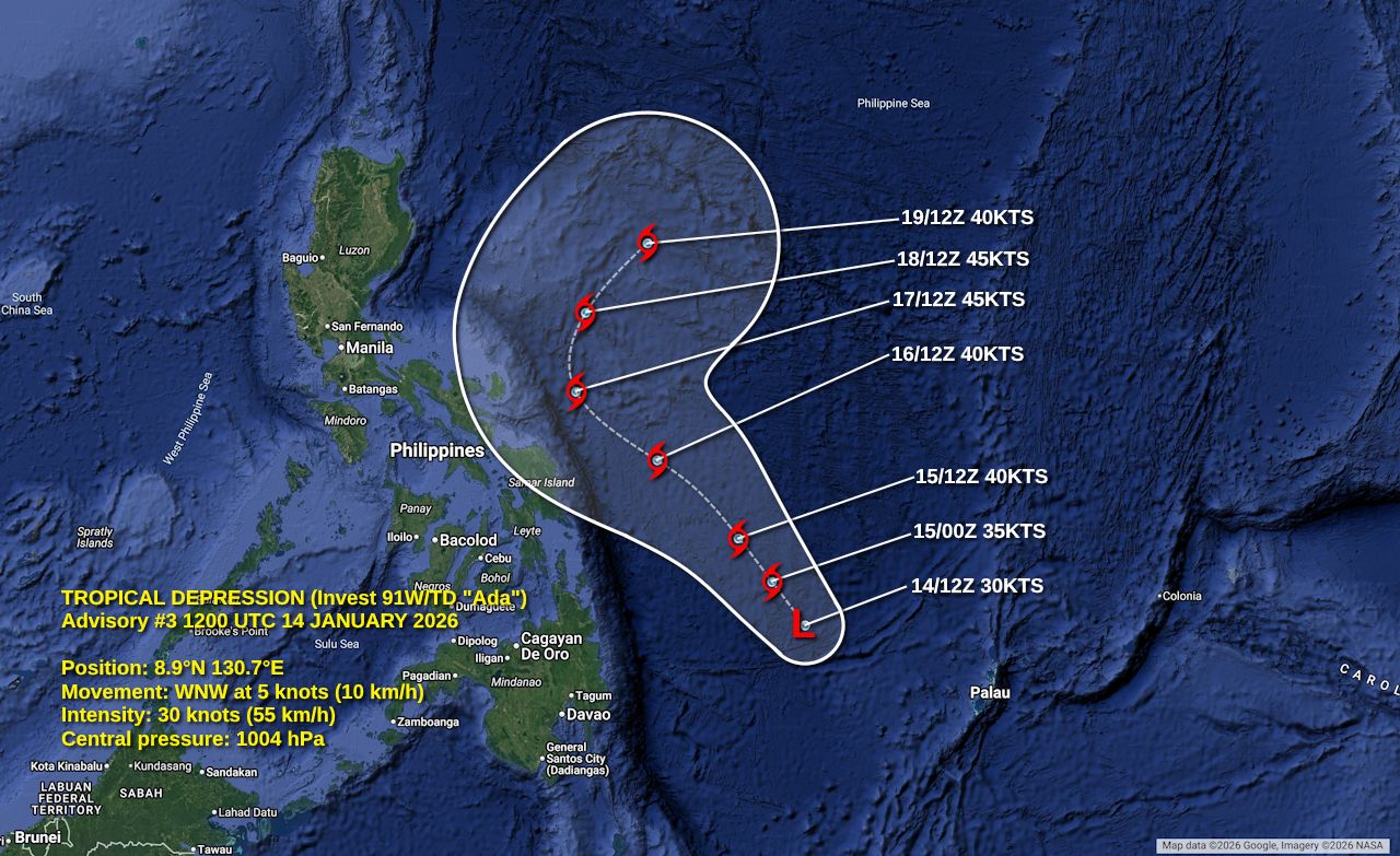
Forecast map
Please support my work by leaving a tip!
Please consider sending a tip via Ko-fi! I wear a lot of hats between a day job, being a photographer, and being a worldwide weather enthusiast, and while I will never put any of my content behind a paywall, your tips definitely help! You can send a tip via the following link: https://ko-fi.com/willweaverrva