- Will Weaver's Weather & Pacific Typhoon Center
- Posts
- Tropical Depression (Invest 91W / Ada) – Tropical Cyclone Advisory #2: 0000 UTC 14 January 2026
Tropical Depression (Invest 91W / Ada) – Tropical Cyclone Advisory #2: 0000 UTC 14 January 2026
Center of tropical depression relocated to the south-southwest. Still moving slowly with no change in strength.
Will Weaver
January 13, 2026
…Center of tropical depression relocated to the south-southwest… …Still moving slowly with no change in strength…

Himawari-9 infrared satellite image (Weathernerds)
Current storm information:
Position: 8.1°N 132.0°E
Movement: NNW at 3 knots (5 km/h)
Intensity: 30 knots (55 km/h)
Central pressure: 1004 hPa
Trend:
Some strengthening is forecast during the next 24 hours, and the depression could become a tropical storm later today.
Watches and warnings:
Areas that should monitor this system: This section is new for 2026 – not every agency issues local tropical cyclone watches or warnings. This is a general list of land areas that should monitor the progress of this system and plan accordingly, whether or not official tropical cyclone watches or warnings are in effect.
| Hazards affecting land:
|
Discussion:
Brief discussion since the previous advisory was only 6 hours ago. Little change with the depression, with most of the convection located north and west of the center, which remains fairly broad. The center has been relocated south-southwest of the previous position based on satellite imagery. Intensity remains 30 kts, based on Dvorak fixes ranging from T1.5 to T2.0.
The forecast philosophy remains the same but is shifted slightly to the west of the previous forecast. The new track is slightly closer to Samar but still does not indicate landfall. Some strengthening is likely through the end of the week before shear increases and the environment becomes drier.
While the current forecast keeps the center of 91W away from any land areas, the system’s large size will likely result in heavy rainfall over Koror and portions of coastal Samar, Leyte, Catanduanes, and northeastern Mindanao through the end of the week.
Forecast positions and maximum winds (1-min)
000 hrs: 08.1°N 132.0°E – 30 kts 55 km/h
012 hrs: 09.0°N 130.9°E – 35 kts 65 km/h
024 hrs: 09.8°N 128.5°E – 40 kts 75 km/h
048 hrs: 11.3°N 127.7°E – 45 kts 85 km/h
072 hrs: 13.2°N 125.5°E – 45 kts 85 km/h
096 hrs: 15.2°N 124.9°E – 40 kts 75 km/h
120 hrs: 16.7°N 126.2°E – 35 kts 65 km/h
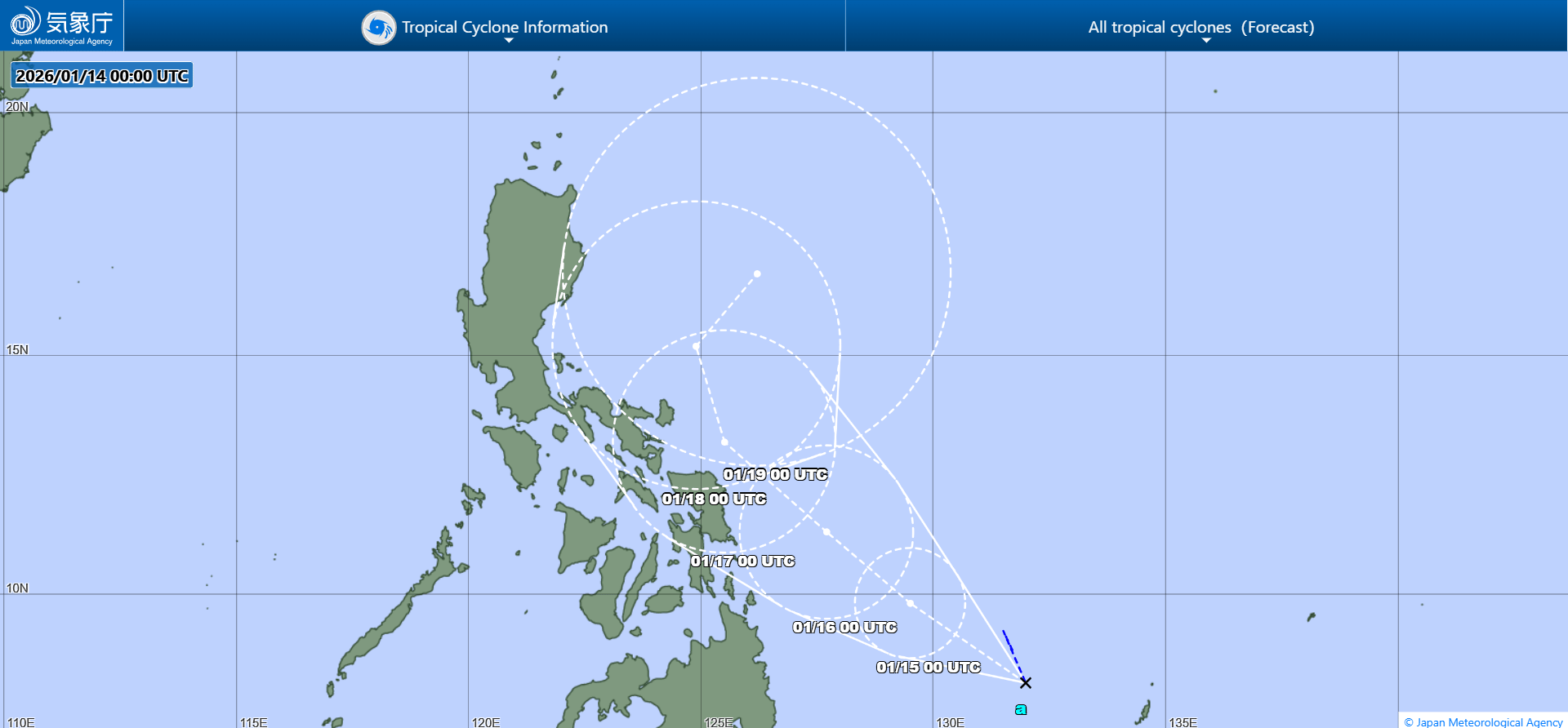
JMA forecast map
Please support my work by leaving a tip!
Please consider sending a tip via Ko-fi! I wear a lot of hats between a day job, being a photographer, and being a worldwide weather enthusiast, and while I will never put any of my content behind a paywall, your tips definitely help! You can send a tip via the following link: https://ko-fi.com/willweaverrva