- Will Weaver's Weather & Pacific Typhoon Center
- Posts
- Tropical Depression (Invest 90W) – Tropical Cyclone Advisory #1: 1200 UTC 8 April 2026
Tropical Depression (Invest 90W) – Tropical Cyclone Advisory #1: 1200 UTC 8 April 2026
Tropical depression forms near Chuuk State. Forecast to move erratically but strengthen significantly during the next few days.
Will Weaver
April 08, 2026
…Tropical depression forms near Chuuk State… …Forecast to move erratically but strengthen significantly during the next few days…

Himawari-9 infrared satellite image (Weathernerds)
Current storm information:
Position: 8.3°N 154.2°E
Movement: WNW at 5 knots (10 km/h)
Intensity: 30 knots (55 km/h)
Central pressure: 1004 hPa
Trend:
Some strengthening is forecast during the next 24 hours.
Watches and warnings:
Areas that should monitor this system:
| Hazards affecting land:
|
Discussion:

GPM GMI 89GHz microwave satellite image (CIRA/RAMMB)
The broad low pressure area near Chuuk State has started becoming better organized. Although the environment is not currently particularly favorable with moderate westerly shear impacting the system and causing its circulation center to become intermittently exposed, the combination of strong easterly flow to the north and near-equatorial westerly flow associated with Tropical Cyclone Maila (30P) in the South Pacific basin has enabled that circulation to quickly become better defined. In addition, the associated convection is showing signs of organization, with microwave satellite imagery indicating some formative banding about three-quarters of the way around the circulation. Recent ASCAT scatterometer data indicates that the system is producing winds of 25 to 30 kts, so the system is now a warning-status tropical depression with an intensity of 30 kts.
The forecast is unusually tricky because of significant spread among the model guidance. While the models are almost unanimous in suggesting that the shear will decrease and allow TD 90W to strengthen - potentially rapidly - during the next few days, they highly disagree on its future track. The GFS-based guidance (including the deterministic and ensemble models) suggest a track much further to the west of the ECMWF and Google DeepMind models. This is unusual as, at the same time, the GFS has a series of fronts moving off the coast of Japan during the forecast period, which would theoretically weaken the subtropical ridge and support a track further to the northwest. Indeed, the ECMWF and Google DeepMind models indicate just that, with tracks generally closer to the Marianas. The current forecast attempts to split the difference, but confidence is quite low. All that can be said for certain at this time is that there will be a decently strong typhoon somewhere in the vicinity of the Marianas by the end of the forecast period, as the environment should become quite conducive for strengthening regardless of the track.
Forecast positions and maximum winds (1-min)
000 hrs: 08.3°N 154.2°E – 30 kts 55 km/h
012 hrs: 08.3°N 153.0°E – 30 kts 55 km/h
024 hrs: 08.5°N 151.8°E – 35 kts 65 km/h
048 hrs: 09.1°N 150.3°E – 45 kts 85 km/h
072 hrs: 09.5°N 149.4°E – 60 kts 110 km/h
096 hrs: 06.4°N 109.1°E – 75 kts 140 km/h
120 hrs: 06.4°N 109.1°E – 85 kts 155 km/h
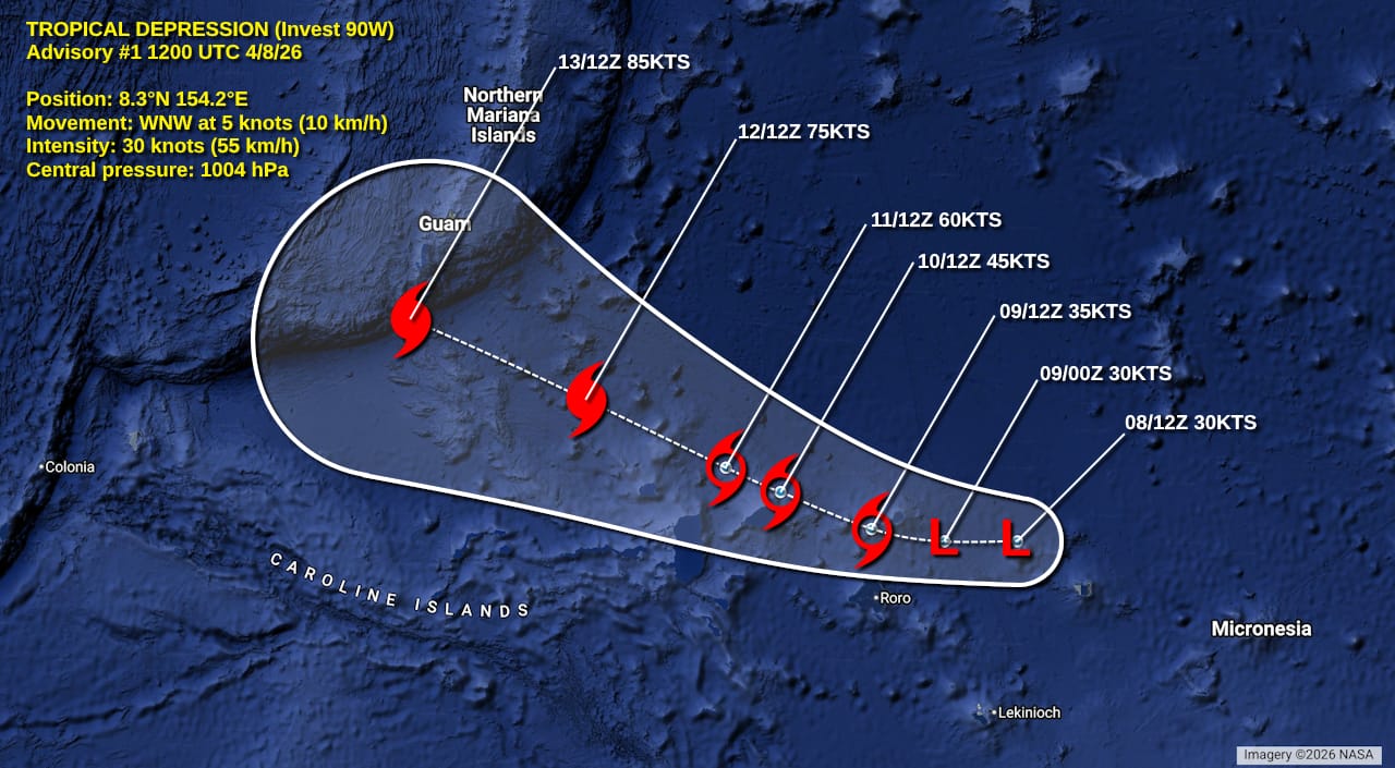
Forecast map
Please support my work by leaving a tip!
Please consider sending a tip via Ko-fi! I wear a lot of hats between a day job, being a photographer, and being a worldwide weather enthusiast, and while I will never put any of my content behind a paywall, your tips definitely help! You can send a tip via the following link: https://ko-fi.com/willweaverrva