- Will Weaver's Weather & Pacific Typhoon Center
- Posts
- Tropical Depression (Invest 90W) - Tropical Cyclone Advisory #1, 1200 UTC 7/1/25
Tropical Depression (Invest 90W) - Tropical Cyclone Advisory #1, 1200 UTC 7/1/25
Tropical depression forms well northeast of the Marianas
Will Weaver
July 01, 2025

…Tropical depression forms well northeast of the Marianas…
Current storm information:
Position: 22.6°N 148.2°E
Movement: NW at 5 knots (10 km/h)
Intensity: 30 knots (55 km/h)
Central pressure: 1006 hPa
Trend:
Some strengthening is forecast during the next 24 hours, and the depression could become a tropical storm on Wednesday.
Watches and warnings:
There are no land-based watches or warnings in effect.
Hazards affecting land:
None.
Discussion:
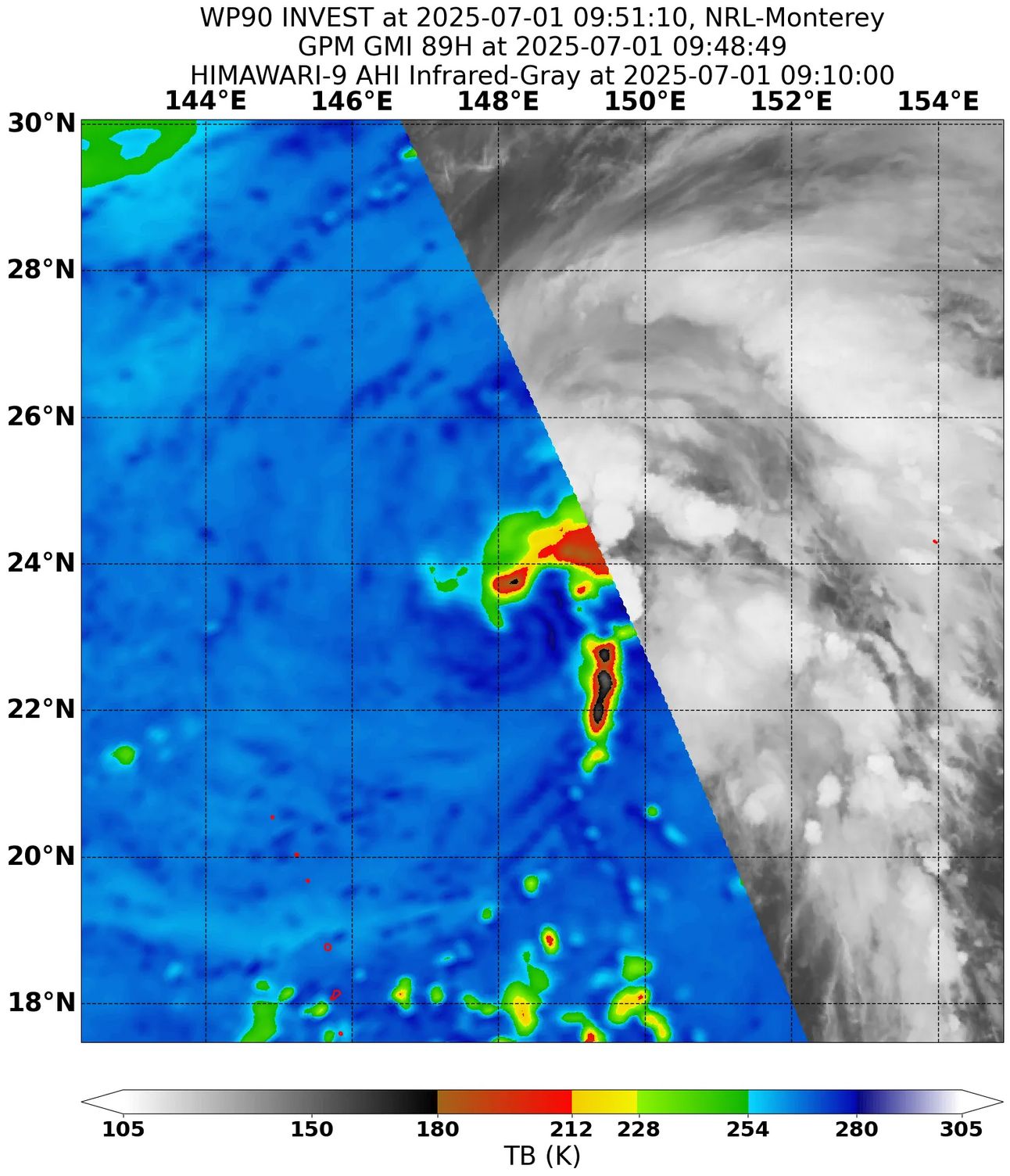
GPM GMI 89GHz microwave satellite image of the TD, showing a fairly well defined circulation and asymmetric convective banding
The area of low pressure located northeast of the Mariana Islands appears to have developed a well defined low-level circulation relatively close to a recent burst of intense convection. The convection has also been organizing into bands, although the system as a whole has a very asymmetric satellite presentation due to interaction with an elongated upper-level low located on the other side of the Marianas. Despite the shear from this upper low, the system has acquired enough organization to be designated a tropical depression. Its initial intensity is 30 kts, based primarily on scatterometer data.
The depression is forecast to move generally northwestward during the next couple of days as it approaches a weakness in the subtropical ridge. The depression should move into the northern semicircle of the upper low on Wednesday, which will decrease the effective shear over it, and this should allow for some gradual strengthening. TD 90W will likely become a tropical storm on Wednesday. By Thursday, the upper low to the south is expected to fill, and this will cause steering currents to collapse - the development of upper-level ridging to the south and the intensification of a new tropical cyclone to the west (98W) will not help matters, and the result is that TD 90W will likely be left meandering well southeast of Japan through the end of the forecast period, with modest strengthening possible in a marginally favorable environment.
Forecast positions and maximum winds
00 hrs: 22.6°N 148.2°E – 30 kts
12 hrs: 24.4°N 146.8°E – 30 kts
24 hrs: 25.8°N 145.7°E – 35 kts
48 hrs: 28.1°N 144.2°E – 40 kts
72 hrs: 29.9°N 144.6°E – 45 kts
96 hrs: 30.6°N 146.0°E – 50 kts
120 hrs: 31.1°N 147.2°E – 50 kts

JMA forecast track