- Will Weaver's Weather & Pacific Typhoon Center
- Posts
- Tropical Depression Chantal (03L) - Tropical Cyclone Update #3, 12:00pm 7/6/25
Tropical Depression Chantal (03L) - Tropical Cyclone Update #3, 12:00pm 7/6/25
Chantal moving inland over the Carolinas, expected to bring pockets of heavy rain to eastern North Carolina and Virginia tonight and Monday
Will Weaver
July 06, 2025
…Chantal moving inland over the Carolinas… …Expected to bring pockets of heavy rain to eastern North Carolina and Virginia tonight and Monday…
Current storm information:
Position: 34.4°N 79.2°W (80 mi W of Wilmington, NC)
Movement: N at 8 knots (9 mph)
Intensity: 30 knots (35 mph)
Central pressure: 1007 hPa
Trend:
Chantal is forecast to weaken as it moves further inland, and it is expected to degenerate into a post-tropical cyclone over central North Carolina on Monday.
Watches and warnings:
Flood watches are in effect for much of central North Carolina and south central Virginia.
Hazards affecting land:
Chantal (and its remnants) is expected to produce pockets of heavy rainfall across portions of central and eastern North Carolina and central and eastern Virginia through Tuesday. Storm total rainfall of 2 to 4 inches, with isolated amounts of 6 inches, is possible throughout the region. Any storms that develop could produce very high rainfall rates of up to 2 inches per hour, and this could cause flash flooding in low-lying areas.

GOES-19 visible satellite image, showing most of the thunderstorm activity associated with Chantal east of its center and over central and eastern North Carolina
Focus on Central Virginia:
The primary risk from Chantal in Central Virginia is pockets of heavy rain, especially on Monday. As Chantal weakens, its associated rainfall will become more scattered, but any thunderstorms that do develop will produce very heavy rain and gusty winds (wind gusts as high as 40 mph). Isolated tornadoes are also possible. The Weather Prediction Center indicates a marginal risk of excessive rainfall for most of southeastern Virginia, including the Richmond area, on Monday.
Once Chantal’s remnants move out of the area, it will leave extremely humid tropical air behind it (dew points in the upper 70s), and very hot temperatures by midweek will cause heat index values to rise into the mid-100s. In addition, there will be chances of showers and thunderstorms pretty much every day this week, and any storms that develop could produce extremely heavy rainfall.
The National Hurricane Center has issued its last advisory on this system - future updates will be provided by the Weather Prediction Center and are available on the NHC’s website.
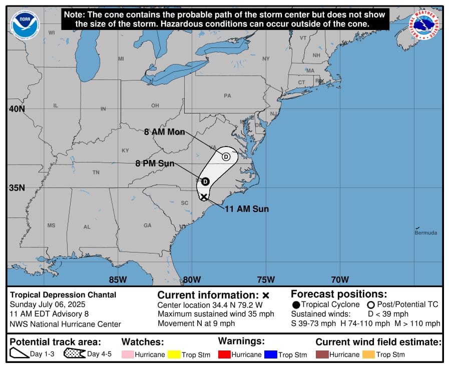
NHC forecast map