- Will Weaver's Weather & Pacific Typhoon Center
- Posts
- Tropical Depression 20W (ex-Jacinto) – Tropical Cyclone Advisory #2: 0000 UTC 29 August 2025
Tropical Depression 20W (ex-Jacinto) – Tropical Cyclone Advisory #2: 0000 UTC 29 August 2025
Tropical Depression 20W remains poorly organized as it continues westward.
…Tropical Depression 20W remains poorly organized as it continues westward…

Himawari-9 visible satellite image (Weathernerds)
Current storm information:
Position: 16.2°N 113.5°E
Movement: W at 10 knots (20 km/h)
Intensity: 30 knots (55 km/h)
Central pressure: 999 hPa
Trend:
Some slow strengthening is possible during the next 24 hours, and the depression could become a tropical storm later today.
Watches and warnings:
| Hazards affecting land:
|
Discussion:

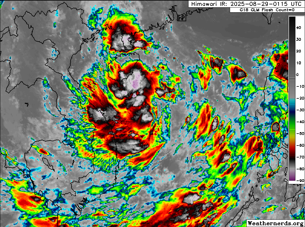
Himawari-9 infrared satellite image (Weathernerds)
Moderate easterly shear continues to plague Tropical Depression 20W, which remains poorly organized this morning. The system continues to consist of a mostly exposed swirl of low clouds with the nearest convection displaced well to the west of the center. The banding that had existed to the south and east of the center has also diminished. The most recent scatterometer data suggests the wind field remains fairly broad with a wide swath of 25 to 30 kt winds mostly located to the northeast of the center. Given these observations and consensus Dvorak fixes of T2.0, the intensity remains 30 kts.
TD 20W is more or less on track, and the forecast is generally unchanged. Moderate to strong easterly shear is expected to persist during the next couple of days, and this will likely preclude any significant strengthening before the system moves over Vietnam on Saturday. Most of the model guidance, including GFS, ECMWF, and Google Deep Mind ensembles, indicate little change in strength before landfall, although there is a chance 20W could briefly reach tropical storm strength as it makes landfall. The vortex should quickly decay over land and dissipate by Sunday.
Forecast positions and maximum winds
00 hrs: 16.2°N 113.5°E – 30 kts
12 hrs: 17.1°N 111.6°E – 30 kts
24 hrs: 17.7°N 109.1°E – 35 kts
48 hrs: 18.1°N 102.4°E – 25 kts inland
72 hrs: Dissipated

JMA forecast map
Please consider sending a tip via Ko-fi! I wear a lot of hats between a day job, being a photographer, and being a worldwide weather enthusiast, and while I will never put any of my content behind a paywall (paywalls kind of defeat the purpose of this blog/newsletter/thingy), your tips definitely help! You can send a tip via the following link: https://ko-fi.com/willweaverrva