- Will Weaver's Weather & Pacific Typhoon Center
- Posts
- Tropical Depression 18W (formerly 92W) – Tropical Cyclone Advisory #4: 1200 UTC 19 August 2025
Tropical Depression 18W (formerly 92W) – Tropical Cyclone Advisory #4: 1200 UTC 19 August 2025
Tropical depression north of Okinawa regenerates.
Will Weaver
August 19, 2025
Current storm information:
Position: 27.9°N 127.1°E
Movement: N at 5 knots (10 km/h)
Intensity: 30 knots (55 km/h)
Central pressure: 1008 hPa
Trend:
Little change in strength is forecast during the next 24 hours.
Watches and warnings:
| Hazards affecting land:
|
Discussion:
Just as JMA and I had given up on 92W, radar data from Okinawa indicated that the system quickly redeveloped a fairly well-defined circulation center slightly to the northwest of its previous estimated location. In addition, convection increased significantly to the north of the center, and scatterometer data indicates the system is producing winds of 25 to 30 kts. Given all of these developments, it looks like I was premature in closing the book on 92W, as JTWC has upgraded it to Tropical Depression 18W with 30 kt winds.
Although 18W has a second shot at life, it won’t be around for long. The environment is still not particularly favorable for strengthening due to dry air being entrained into 18W’s circulation by an upper-level low off the eastern coast of Taiwan. As 18W moves away from the upper-level low, it could encounter a slightly more moist air mass, which would allow for some modest strengthening, and 18W could briefly become a tropical storm on Wednesday. By Thursday, however, a strong ridge of high pressure is forecast to build over the Korean Peninsula, which will lead to a dramatic increase in mid- to upper-level shear over 18W, and 18W will likely dissipate (for real) late Thursday or early Friday.
Forecast positions and maximum winds
00 hrs: 27.9°N 127.1°E – 30 kts
12 hrs: 29.8°N 127.1°E – 30 kts
24 hrs: 31.2°N 127.4°E – 35 kts
48 hrs: 32.4°N 128.2°E – 30 kts
72 hrs: Dissipated
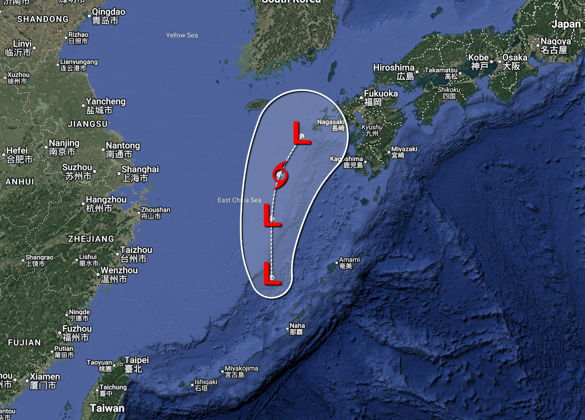
Forecast map