- Will Weaver's Weather & Pacific Typhoon Center
- Posts
- Tropical Depression 11W – Tropical Cyclone Advisory #1: 0000 UTC 23 July 2025
Tropical Depression 11W – Tropical Cyclone Advisory #1: 0000 UTC 23 July 2025
Another tropical depression forms along the northwestern coast of Luzon. Expected to be short-lived but could strengthen rapidly and will contribute to an ongoing flooding threat.
Will Weaver
July 22, 2025
…Another tropical depression forms along the northwestern coast of Luzon… …Expected to be short-lived but could strengthen rapidly and will contribute to an ongoing flooding threat…
 Himawari-9 visible satellite image (Weathernerds) | Current storm information:
Trend:
|
Watches and warnings:
| Hazards affecting land:
|
Discussion:
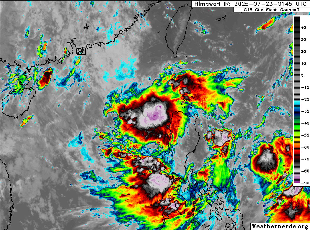
Himawari-9 infrared satellite image (Weathernerds)
One of the low pressure centers located along the broad monsoon gyre extending from the central South China Sea across Luzon into the Philippine Sea has dramatically improved in organization during the past 24 hours or so. Unlike most monsoonal disturbances, this system is fairly compact with a small area of flaring convection obscuring a rather small circulation center. Scatterometer data indicates that this circulation is fairly well defined and is producing winds of 25 to 30 knots. The system has also picked up T1.5 to T2.0 Dvorak fixes from PGTW and KNES, and so warnings are initiated on Tropical Depression 11W with an intensity of 30 kts.
Unlike most of the systems embedded in the monsoon gyre, 11W is located in a very favorable environment consisting of a pocket of low to moderate shear and very warm waters. Given the compactness of its circulation, 11W is certainly a candidate for rapid intensification. 11W is forecast to loop off the western coast of Luzon within the monsoon flow before turning northeastward and making landfall south of Vigan late Thursday night or early Friday morning. After landfall, 11W is forecast to rapidly accelerate northeastward as the monsoon gyre breaks down, and most of the model guidance dissipates the circulation south of the Yaeyama Islands by this weekend.
Tropical Depression 11W is expected to contribute even more rain and potentially destructive winds to an already dangerous and life-threatening situation occurring along the western coastal areas of Luzon. Interests along the coast between Vigan and Baguio should monitor the progress of 11W, as it could be near typhoon strength when it makes landfall.
Forecast positions and maximum winds
00 hrs: 18.8°N 120.5°E – 30 kts
12 hrs: 17.8°N 119.1°E – 40 kts
24 hrs: 17.0°N 118.7°E – 55 kts
36 hrs: 17.1°N 120.1°E – 60 kts near the coast
48 hrs: 18.7°N 121.7°E – 35 kts near the Babuyan Islands
72 hrs: 23.2°N 124.6°E – 25 kts Post-tropical/remnant low
96 hrs: Dissipated

JTWC forecast map