- Will Weaver's Weather & Pacific Typhoon Center
- Posts
- Super Typhoon Sinlaku (04W) – Tropical Cyclone Advisory #9: 1500 UTC 12 April 2026
Super Typhoon Sinlaku (04W) – Tropical Cyclone Advisory #9: 1500 UTC 12 April 2026
Sinlaku rapidly becomes a potentially catastrophic Category 5 super typhoon. Typhoon warnings issued for Rota, Tinian, and Saipan. This is a particularly dangerous situation!
Will Weaver
April 12, 2026
…Sinlaku rapidly becomes a potentially catastrophic Category 5 super typhoon…
…Typhoon warnings issued for Rota, Tinian, and Saipan…
…This is a particularly dangerous situation…
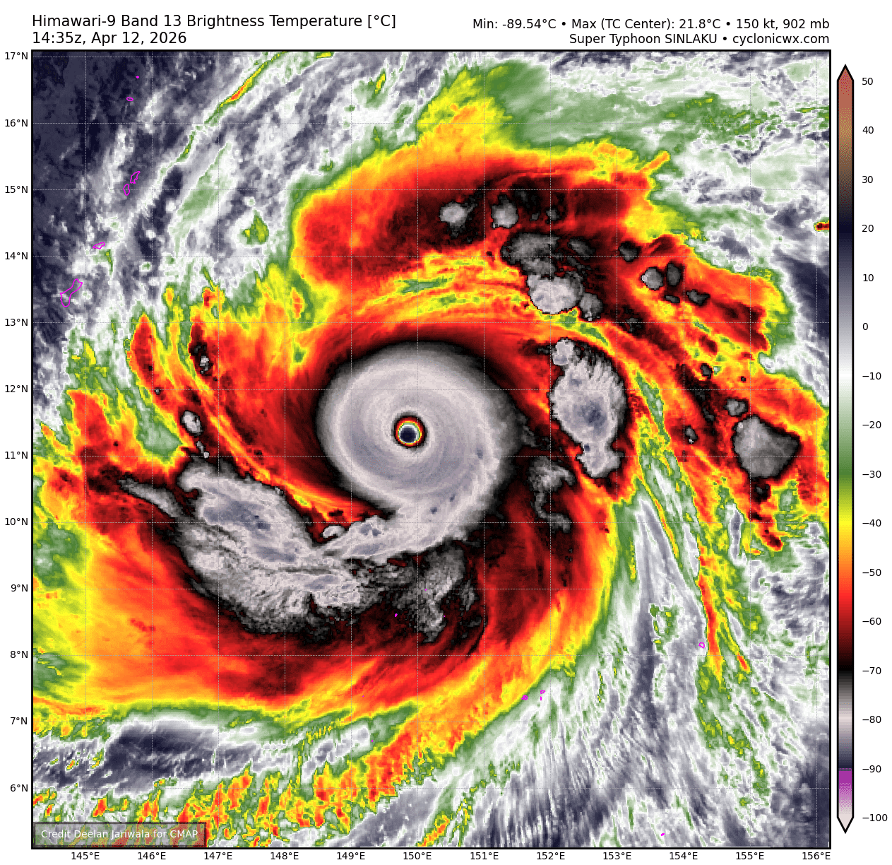
Himawari-9 infrared satellite image (CyclonicWx)
Current storm information:
Position: 11.1°N 150.2°E
Movement: NNW at 9 knots (15 km/h)
Intensity: 150 knots (280 km/h)
Intensity category: 5
Central pressure: 899 hPa
Trend:
Fluctuations in intensity are likely during the next 24 hours, but further strengthening cannot be ruled out.
Watches and warnings:
Areas that should monitor this system:
| Hazards affecting land:
|
Discussion:
This advisory was held for a bit because I wanted all the data before writing it. Sinlaku’s rapid intensification has been nothing short of mind blowing considering it is mid-April, and it is a harbinger of the impending El Niño event that is developing. Sinlaku has an extremely impressive satellite appearance that rivals some of the most intense Western Pacific tropical cyclones, with an almost perfectly symmetric central dense overcast surrounding a large, clear, and very warm eye. Sinlaku also sports impressive radial outflow in all quadrants. The only indication that Sinlaku has of possibly peaking in intensity is a possible secondary eyewall forming just to the east of the center, as indicated in a recent RCM SAR pass. The intensity is increased to an unbelievable 150 kts, and this may be conservative - because of the extremely cold convection and the very warm eye, CIMSS ADT and D-PRINT estimates have shot up to 163-164 kts, SATCON estimates 158 kts, while manual Dvorak estimates from PGTW, KNES, and RJTD are a consensus T7.5. It is possible the actual intensity is closer to 155 or 160 kts.
The forecast track has been nudged slightly to the north of the previous one owing to Sinlaku’s slow movement and extreme intensity, and it is likely to interact more with the trough amplifying off the coast of Japan than previously thought. On this track, Sinlaku is forecast to pass directly over Tinian and Saipan on Tuesday. While the intensity is likely to fluctuate due to unpredictable inner eyewall dynamics and potential eyewall replacement cycles, until an eyewall replacement cycle actually begins, it is very possible that Sinlaku could strengthen even more, and it could reach its Maximum Potential Intensity for this region.
As Sinlaku approaches the CNMI, it should move over slightly cooler waters that cannot support such an extreme intensity, and shear will gradually increase. This should result in slow weakening beginning on Monday evening, although this weakening will be gradual enough that Sinlaku will likely still be near or at Category 5 strength as it moves over Tinian and Saipan. After it clears the islands, a turn to the north is expected as Sinlaku rounds the subtropical ridge. By Wednesday evening, progressively cooler SSTs and increasing shear should lead to a more profound weakening trend, though Sinlaku will likely remain an intense typhoon near the northernmost Mariana Islands through Thursday evening. By the end of the forecast period, Sinlaku is likely to begin extratropical transition as it turns northeastward.
Forecast positions and maximum winds (1-min)
000 hrs: 11.1°N 150.2°E – 150 kts 280 km/h
012 hrs: 12.2°N 149.0°E – 160 kts 295 km/h
024 hrs: 13.3°N 147.7°E – 150 kts 280 km/h
048 hrs: 15.3°N 145.7°E – 140 kts 260 km/h
072 hrs: 17.4°N 144.7°E – 120 kts 220 km/h
096 hrs: 19.8°N 144.6°E – 105 kts 195 km/h
120 hrs: 22.6°N 145.4°E – 80 kts 150 km/h
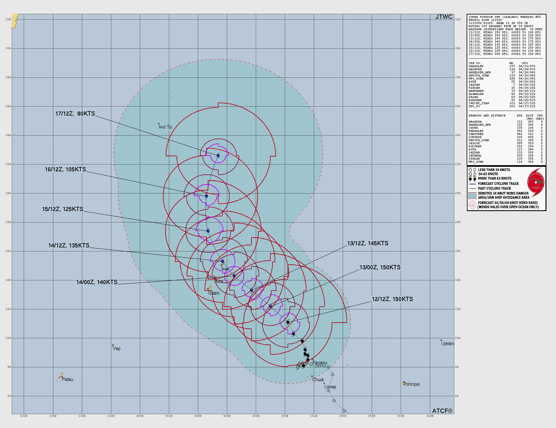
JTWC forecast map