- Will Weaver's Weather & Pacific Typhoon Center
- Posts
- Severe Tropical Storm Wipha (#09W) – Tropical Cyclone Advisory #12: 1200 UTC 21 July 2025
Severe Tropical Storm Wipha (#09W) – Tropical Cyclone Advisory #12: 1200 UTC 21 July 2025
Wipha restrengthens slightly while continuing to traverse the Gulf of Tonkin
Will Weaver
July 21, 2025
…Wipha restrengthens slightly while continuing to traverse the Gulf of Tonkin…
 Himawari-9 infrared satellite image (Weathernerds) | Current storm information:
Trend:
|
Watches and warnings:
| Hazards affecting land:
|
Discussion:

Himawari-9 infrared satellite image (Weathernerds)
Wipha has gotten a bit better organized since the previous advisory now that its center is fully over water. The central dense overcast has become less ragged with very intense convection beginning to wrap back around the circulation center. Radar data backs this up, with an area of very intense convection south and west of the center. The center itself appears to have made a slight jump to the south of its previous track and location. Despite these improvements in Wipha’s structure, it is already beginning to exhibit signs of being impacted by increasing easterly shear, as the equatorward outflow channel is becoming restricted. The intensity is increased to 50 kts, based primarily on surface observations and also on CIMSS ADT and D-PRINT estimates of about 50 kts.

Composite radar image (CyclonicWx)
There are no changes to the forecast. Wipha is forecast to make landfall in Vietnam near Halong in about 12 hours and pass just to the south of Hanoi. A little bit of additional strengthening is possible before then. After landfall, rugged terrain and strong shear should make quick work of Wipha’s circulation, and Wipha should dissipate over northern Laos on Wednesday or Thursday.
Forecast positions and maximum winds
00 hrs: 21.0°N 108.4°E – 50 kts
12 hrs: 20.6°N 107.2°E – 55 kts on the coast
24 hrs: 20.6°N 105.9°E – 40 kts inland
48 hrs: 20.7°N 103.2°E – 25 kts Post-tropical/remnant low inland
72 hrs: Dissipated
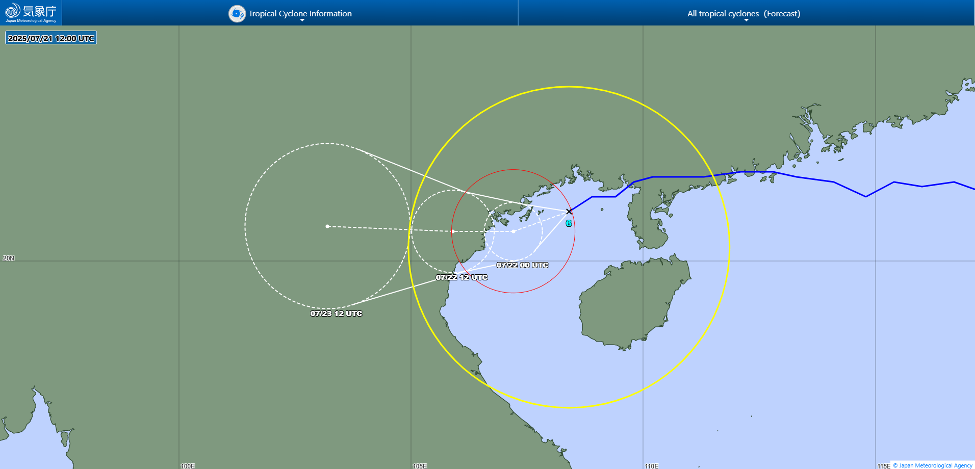
JMA forecast map