- Will Weaver's Weather & Pacific Typhoon Center
- Posts
- Severe Tropical Storm Krosa (12W) – Tropical Cyclone Advisory #6: 0000 UTC 26 July 2025
Severe Tropical Storm Krosa (12W) – Tropical Cyclone Advisory #6: 0000 UTC 26 July 2025
Krosa strengthens but stalls west of the northernmost Mariana Islands.
Will Weaver
July 25, 2025
…Krosa strengthens but stalls west of the northernmost Mariana Islands…
 Himawari-9 visible satellite image (Weathernerds) | Current storm information:
Trend:
|
Watches and warnings:
| Hazards affecting land:
|
Discussion:
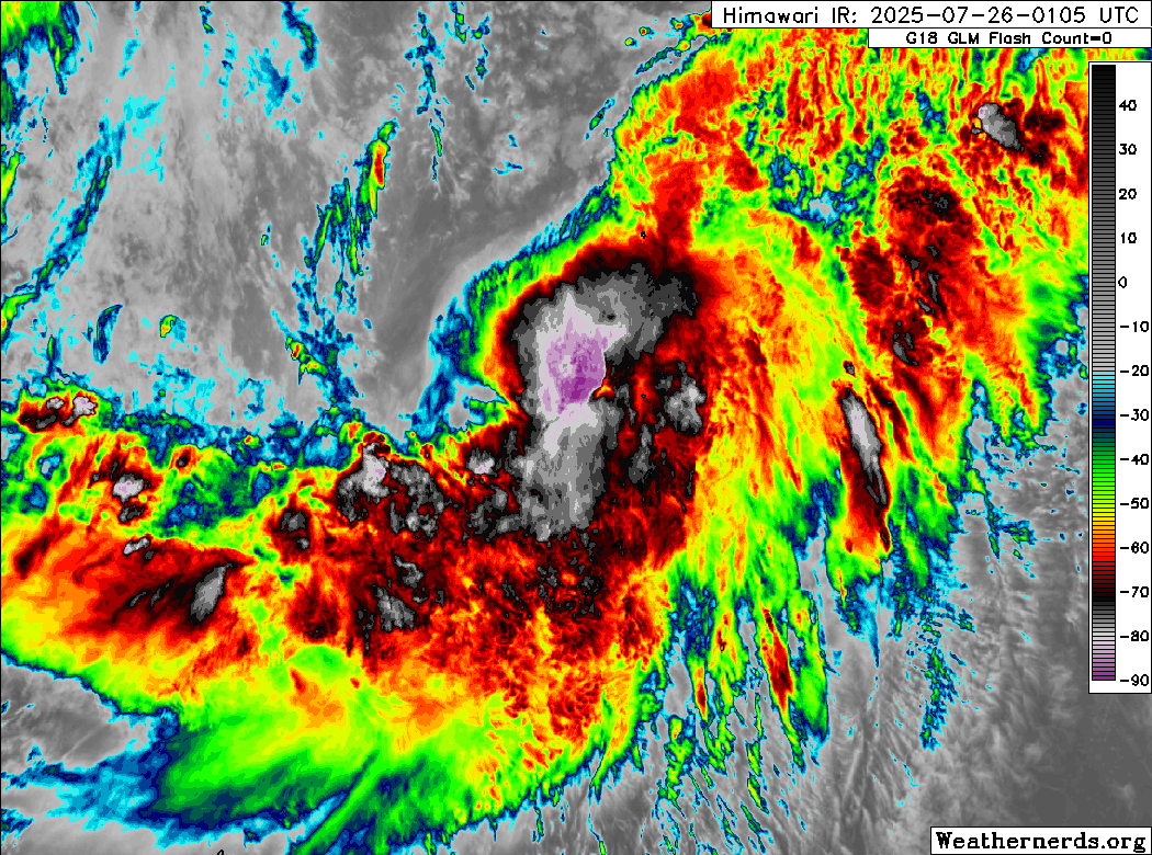
Himawari-9 infrared satellite image (Weathernerds)
Krosa continues to withstand an absolute pummeling by strong (30 to 40 kts) northwesterly wind shear, but the system has also ground to a halt, likely as a result of the large monsoon gyre to the west beginning to break down. It appears the shear has also begun to decrease, as the convection is beginning to become more symmetric and is increasing in coverage north and west of the center. Meanwhile, synthetic passive microwave imagery indicates that an inner core is finally beginning to establish itself, with a partial ring of intense convection wrapping into the center from the south and east. The intensity is increased to 50 kts, hedged between shear-pattern T3.0 to T3.5 Dvorak fixes from KNES, PGTW, and RJTD.

Synthetic passive microwave image (RAMMB/CIRA)
Now that the monsoon gyre has begun to break down, the main steering mechanism for Krosa should switch to a strong subtropical ridge over the north central Pacific. Although Krosa is currently stationary, it should resume a northward motion later today. As the shear decreases, the environment should favor some gradual strengthening, and Krosa will likely approach typhoon intensity by Sunday. By Monday, however, Krosa will encounter a drier air mass, which will likely cause its intensity to level off or even decrease on Monday into Tuesday. By midweek, the monsoonal pattern is expected to collapse into a wide belt of southwesterly wind flow extending from the Philippines clear up into the subtropical Central Pacific which will moisten the environment and enable some additional strengthening. It is possible that Krosa could reach typhoon strength (again) by the end of the forecast period.
The models continue to suggest that this mega-monsoon trough forecast to develop in the subtropical Pacific could enable Krosa to retain tropical characteristics for much longer than normal, and Krosa could become an unusually long-lived system. However, once it clears the northern Marianas, it will not be a threat to any land areas.
Forecast positions and maximum winds
00 hrs: 17.7°N 143.5°E – 50 kts
12 hrs: 19.4°N 145.0°E – 55 kts
24 hrs: 21.5°N 145.5°E – 60 kts
48 hrs: 26.4°N 145.6°E – 60 kts
72 hrs: 28.6°N 144.8°E – 50 kts
96 hrs: 29.5°N 145.7°E – 60 kts
120 hrs: 30.4°N 148.0°E – 65 kts

JMA forecast map