- Will Weaver's Weather & Pacific Typhoon Center
- Posts
- Severe Tropical Storm Kajiki (19W) – Tropical Cyclone Advisory #4: 1500 UTC 23 August 2025
Severe Tropical Storm Kajiki (19W) – Tropical Cyclone Advisory #4: 1500 UTC 23 August 2025
Kajiki rapidly intensifying as it moves quickly across the South China Sea.
Will Weaver
August 23, 2025
…Kajiki rapidly intensifying as it moves quickly across the South China Sea…

Himawari-9 infrared satellite loop (Weathernerds)
Current storm information:
Position: 17.7°N 113.0°E
Movement: W at 10 knots (20 km/h)
Intensity: 55 knots (100 km/h)
Central pressure: 990 hPa
Trend:
Steady to rapid strengthening is expected during the next 12 to 18 hours and Kajiki is expected to become a typhoon on Sunday morning. This intensification should level off as Kajiki passes near or over Hainan Island early Monday.
Watches and warnings:
| Hazards affecting land:
|
Discussion:
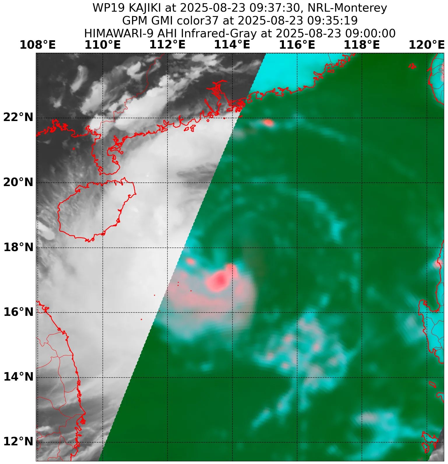
GPM GMI 37GHz microwave satellite image
Kajiki appears to be rapidly intensifying. Intense convection continues to flare and wrap around the center, and an eye feature is intermittently visible on conventional satellite imagery. GPM GMI microwave satellite imagery depicts a partial mid-level eyewall with the strongest convection located on the southern side, and this is typically a harbinger of rapid intensification. Although CIMSS shear analysis indicates about 15 to 20 kts of mid-level shear impacting the system, Kajiki’s relatively fast forward speed seems to be offsetting this. In recent hours, a particularly intense burst of convection developed in the southern semicircle and seems to be in the process of wrapping around the center, which may be what Kajiki needs to complete its eyewall. The intensity is increased to a potentially conservative 55 kts, hedged between a range of Dvorak estimates from T3.5 to T4.0, a CIMSS ADT estimate of 59 kts, and a D-PRINT estimate of 54 kts.
No changes to the forecast are necessary. Kajiki continues to ride the southwestern edge of a subtropical ridge building westward, and it is forecast to move slightly north of due west through the end of the forecast period. Conditions appear favorable for continued rapid intensification, with CIMSS AI-RI and RAMMB RIPA guidance indicating high probabilities of RI during the next 24 hours (RIPA has a 43.4% chance of a 35 kt increase in the next 24 hours). Kajiki is expected to become a typhoon during the next few hours, and it could peak near or at Category 2 status before passing very near or over southern Hainan Island on Sunday evening. This passage over land should put an end to Kajiki’s intensification and probably even weaken the system before it moves into the Gulf of Tonkin. However, Kajiki is expected to still be a typhoon when it makes its final landfall in north central Vietnam on Monday. Rapid weakening is forecast after landfall, and Kajiki will likely degenerate into a broad area of low pressure over northern Thailand on Tuesday.
It should be noted that some of the model guidance suggests the potential for regeneration into a tropical cyclone in the Bay of Bengal later next week.
Forecast positions and maximum winds
00 hrs: 17.7°N 113.0°E – 55 kts
12 hrs: 18.1°N 111.2°E – 75 kts
24 hrs: 18.4°N 109.0°E – 80 kts inland over Hainan Island
36 hrs: 18.7°N 106.9°E – 65 kts over water
48 hrs: 19.0°N 104.9°E – 45 kts inland over Vietnam
72 hrs: 19.6°N 100.8°E – 25 kts Post-tropical/remnant low inland
96 hrs: 20.1°N 97.5°E – 20 kts Post-tropical/remnant low inland
120 hrs: Dissipated

JTWC forecast map
One last thing…
Do you like what you see? Please consider sending a tip via Ko-fi! I wear a lot of hats between a day job, being a photographer, and being a worldwide weather enthusiast, and while I will never put any of my content behind a paywall (paywalls kind of defeat the purpose of this blog/newsletter/thingy), your tips definitely help! You can send a tip via the following link: https://ko-fi.com/willweaverrva