- Will Weaver's Weather & Pacific Typhoon Center
- Posts
- Severe Tropical Storm Bualoi (#26W) – Tropical Cyclone Advisory #13: 1200 UTC 29 September 2025
Severe Tropical Storm Bualoi (#26W) – Tropical Cyclone Advisory #13: 1200 UTC 29 September 2025
Bualoi still a tropical storm over northwestern Laos and about to exit the Western Pacific basin.
Will Weaver
September 29, 2025
…Bualoi still a tropical storm over northwestern Laos and about to exit the Western Pacific basin…
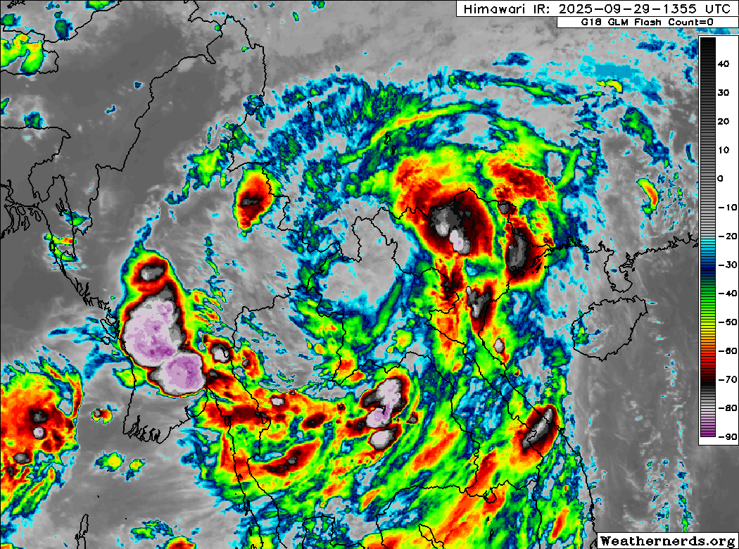
Himawari-9 infrared satellite image (Weathernerds)
Current storm information:
Position: 20.5°N 101.5°E
Movement: WNW at 10 knots (20 km/h)
Intensity: 50 knots (95 km/h)
Central pressure: 985 hPa
Trend:
Rapid weakening is forecast during the next 24 hours, and Bualoi will likely dissipate on Tuesday.
Watches and warnings:
| Hazards affecting land:
|
Discussion:
Despite being located well inland and over rugged terrain, Bualoi continues to have a very well defined circulation, and it is still a tropical cyclone. However, the passage over land has taken its toll on the system in that its core convection has mostly dissipated, although there remains substantial convection along the outer fringes of the circulation thanks to interaction with a monsoon trough in the Bay of Bengal. Recent scatterometer data indicates that Bualoi’s large circulation is still producing tropical storm force winds along the Vietnam coast, and D-PRINT recently gave an estimate of 53 kts. Accounting for additional decay over land, the intensity is lowered to 50 kts.
Although Bualoi has proven to be resilient, it is not likely to be around much longer. In fact, we will soon have to leave Bualoi behind regardless as it is about to leave the Western Pacific basin (which ends at 100°E outside the Gulf of Thailand), and the next advisory will probably be the last regardless of Bualoi’s status. But for now, the circulation should continue moving west-northwestward into Thailand during the next day or so. Most of the model guidance decays the circulation into a trough on Tuesday as it begins to interact with a broad low pressure area currently forming in the Bay of Bengal, and that low should absorb whatever is left of Bualoi by midweek.
Forecast positions and maximum winds
000 hrs: 20.5°N 101.5°E – 50 kts inland
012 hrs: 21.5°N 098.5°E – 30 kts inland
024 hrs: Dissipated