- Will Weaver's Weather & Pacific Typhoon Center
- Posts
- Severe Tropical Storm #Bualoi (26W/Opong) – Tropical Cyclone Advisory #3: 1200 UTC 24 September 2025
Severe Tropical Storm #Bualoi (26W/Opong) – Tropical Cyclone Advisory #3: 1200 UTC 24 September 2025
Bualoi intensifying east of the Philippines and could briefly become a typhoon later tonight.
Will Weaver
September 24, 2025
…Bualoi intensifying east of the Philippines and could briefly become a typhoon later tonight…
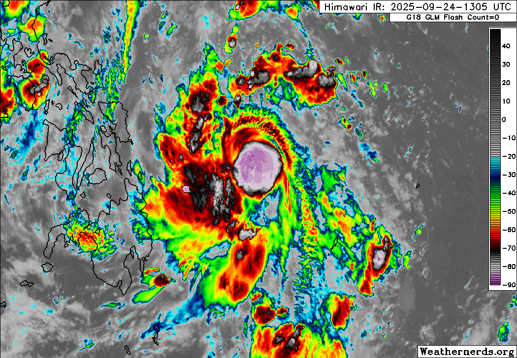
Himawari-9 infrared satellite image (Weathernerds)
Current storm information:
Position: 10.3°N 131.3°E
Movement: W at 5 knots (10 km/h)
Intensity: 60 knots (110 km/h)
Central pressure: 986 hPa
Trend:
Some slight strengthening is forecast during the next 24 hours, and Bualoi could briefly become a typhoon later tonight or on Thursday.
Watches and warnings:  PAGASA wind signal map (click to enlarge)
| Hazards affecting land:
|
Discussion:

WSFM MWI 89GHz microwave satellite image
Bualoi continues to have a somewhat ragged satellite presentation, but it is clear that the tropical cyclone is intensifying at a fairly quick pace. Microwave satellite imagery indicates that convective banding has begun wrapping very tightly into Bualoi’s circulation center, and a partial eyewall feature has developed. On the outside, however, Bualoi consists of clusters of convection that are struggling to coalesce into a central dense overcast feature, with most of the convection located to the east of the center. There is also noticeable feathering of the convection within the eastern semicircle, which is a sign of increasing shear. This is being offset by strong poleward outflow courtesy of an elongated TUTT cell centered just to the southwest of Okinawa. Dvorak estimates range from T3.0 to T4.0 with RJTD on the high end of that range, and given the microwave presentation, it seems reasonable that the intensity is near the high end, and the intensity is increased to 60 kts.
So, the short-term forecast for Bualoi is rather complicated. Bualoi’s structure would suggest the potential for rapid intensification, and it is located over very warm SSTs and getting very strong outflow enhancement from the aforementioned TUTT cell. However, this TUTT cell is weakening, and Bualoi also appears to be experiencing increasing easterly shear. Therefore, it seems likely that Bualoi will become a typhoon during the next few hours, but an increasingly unfavorable environment will likely result in Bualoi weakening back to a tropical storm before it moves over Samar and/or the Bicol Region on Friday. Additional weakening is expected as Bualoi moves over land, although brief passages over water could slow the weakening trend. Bualoi is expected to move out over the South China Sea on Saturday, where the environment should be conducive for restrengthening. Bualoi will likely become a typhoon again as it approaches Hainan Island on Sunday, and it will probably maintain typhoon status moving across that island up until it makes its final landfall in northern Vietnam on Monday.
It should be noted that there is fairly low confidence in the short-term intensity forecast, although again, no rapid intensification guidance has tripped at this time.
Forecast positions and maximum winds
000 hrs: 10.3°N 131.3°E – 60 kts
012 hrs: 11.0°N 129.9°E – 65 kts
024 hrs: 12.3°N 127.7°E – 55 kts
048 hrs: 13.6°N 121.6°E – 50 kts
072 hrs: 15.1°N 114.1°E – 65 kts
096 hrs: 18.0°N 109.9°E – 75 kts inland
120 hrs: 21.1°N 105.4°E – 30 kts inland
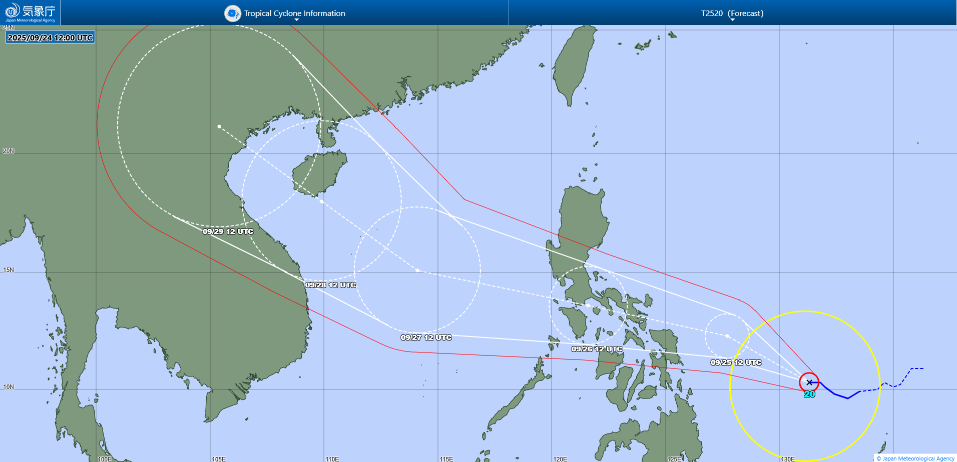
JMA forecast map