- Will Weaver's Weather & Pacific Typhoon Center
- Posts
- Post-Tropical Cyclone Nakri (29W) – Tropical Cyclone Advisory #14 (FINAL): 1200 UTC 14 October 2025
Post-Tropical Cyclone Nakri (29W) – Tropical Cyclone Advisory #14 (FINAL): 1200 UTC 14 October 2025
Nakri rapidly becoming a post-tropical cyclone. This is the last advisory.
Will Weaver
October 14, 2025
…Nakri rapidly becoming a post-tropical cyclone… ...This is the last advisory...
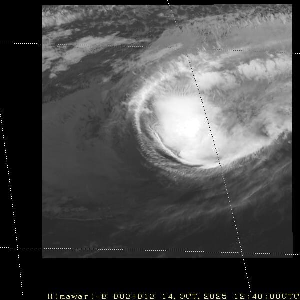
Himawari-8 infrared satellite image (JMA)
Current storm information:
Position: 36.0°N 158.1°E
Movement: E at 28 knots (50 km/h)
Intensity: 70 knots (130 km/h)
Central pressure: 980 hPa
Trend:
Gradual weakening is forecast during the next 24 hours.
Watches and warnings:
| Hazards affecting land:
|
Discussion:

Himawari-8 water vapor satellite image (CyclonicWx) with some features marked. Nakri is marked with a red low pressure symbol and circled. Brown dashed lines indicate frontal boundaries.
Nakri made a rather unexpected comeback over the past 12 to 18 hours. That eye feature that I had thought was transient became better defined since the previous advisory, and at around 0700 UTC microwave satellite imagery indicated that Nakri had closed off a pinhole eye feature with a solid eyewall, though the convection was strongest on its eastern side. This led to a reanalysis of Nakri’s intensity during the past 24 hours, and it was adjusted upward. Since then, however, the shear appears to have gotten the better of Nakri, and its convective structure is in the process of being blown away with cloud tops rapidly warming and the circulation center beginning to become exposed and embedded within dry air. Nakri also continues to display well-defined frontal features and appears to be becoming embedded within the mid-latitude jet stream. It appears very likely that Nakri will complete extratropical transition in less than 12 hours, so this is the last advisory. The intensity is 70 kts, based on Dvorak fixes of T4.0 from PGTW and RJTD and CIMSS ADT and D-PRINT estimates ranging from 63 to 77 kts.
Nakri, or rather its post-tropical remnants, is expected to continue racing eastward. As it becomes more involved with a frontal boundary draped over the northern Pacific, its circulation will likely become stretched out along the front and dissipate within it by Wednesday evening.
This is the last advisory on Nakri.
Forecast positions and maximum winds
000 hrs: 36.0°N 158.1°E – 70 kts
012 hrs: 35.8°N 163.8°E – 50 kts Post-tropical/extratropical
024 hrs: 35.5°N 169.6°E – 35 kts Post-tropical/extratropical
048 hrs: Dissipated