- Will Weaver's Weather & Pacific Typhoon Center
- Posts
- Hurricane Erin (05L) - Tropical Cyclone Update #6 (FINAL) - 11 AM EDT 8/22/25
Hurricane Erin (05L) - Tropical Cyclone Update #6 (FINAL) - 11 AM EDT 8/22/25
Erin losing tropical characteristics as it accelerates out to sea. This is the last update but dangerous heavy surf and rip currents will likely persist at the beaches through early next week.
Will Weaver
August 22, 2025
…Erin losing tropical characteristics as it accelerates out to sea… …This is the last update but dangerous heavy surf, coastal flooding, and rip current risk will persist through early next week…
Current storm information:
Position: 38.8°N 63.1°W
Movement: ENE at 24 knots (28 mph)
Intensity: 80 knots (90 mph) [Cat 1]
Central pressure: 956 mb
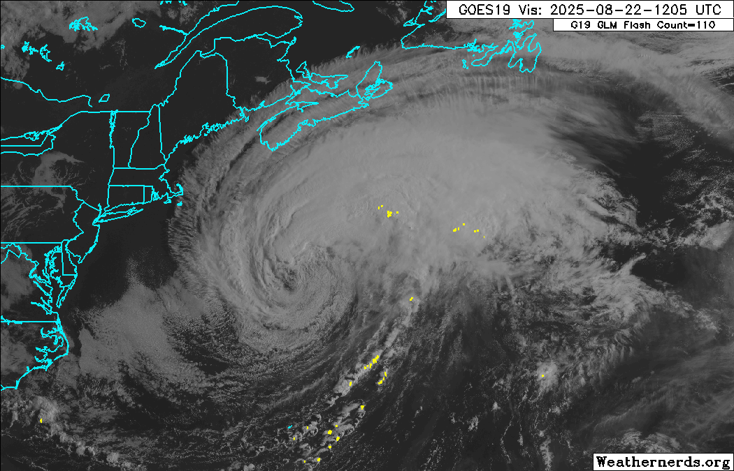
GOES-19 visible satellite loop of Erin. Erin is increasingly looking like an extratropical (frontal) cyclone, with thunderstorm activity becoming displaced to the northeast of the exposed circulation center. (Weathernerds)
Trend:
Gradual weakening is forecast during the next 24 hours. Erin is expected to become a powerful hurricane-force post-tropical cyclone later today or tomorrow, and it will likely retain hurricane force winds through the weekend.
Watches and warnings:
All coastal tropical cyclone watches and warnings have been discontinued. However, coastal flood warnings remain in effect for coastal areas of Virginia along the Chesapeake Bay and the Atlantic coasts, as well as tidal portions of the Potomac, Rappahannock, York, and James Rivers.
Hazards affecting land:

NWS coastal flood risk map for today. Much of southeastern Virginia remains under a minor to moderate coastal flood risk.
Although Erin is moving away from the coast and is no longer producing tropical storm conditions, large swells generated by the hurricane will continue to produce extremely dangerous heavy surf and life-threatening rip currents at the beaches through early next week. Coastal roads, such as Route 12 in the Outer Banks, could remain impassable for days.
Focus on Central Virginia:
Conditions across central and southeastern Virginia have dramatically improved during the past 24 hours, with downright beautiful conditions over much of the region this morning. However, conditions are expected to remain dangerous at the beaches and along the Chesapeake Bay coast during the next few days as it will take some time for the large swells generated by Erin to subside. Extremely dangerous heavy surf and rip currents will persist at the beaches at least through Monday, and there remains a moderate to high risk of coastal flooding through the weekend. These conditions should gradually subside by Monday or Tuesday.
This is the last update on Erin. For additional information, refer to products from your local weather office or the National Hurricane Center at http://www.hurricanes.gov.
One last thing…
Do you like what you see? Please consider sending a tip via Ko-fi! I wear a lot of hats between a day job, being a photographer, and being a worldwide weather enthusiast, and while I will never put any of my content behind a paywall (paywalls kind of defeat the purpose of this blog/newsletter/thingy), your tips definitely help! You can send a tip via the following link: https://ko-fi.com/willweaverrva