- Will Weaver's Weather & Pacific Typhoon Center
- Posts
- Hurricane Erin (05L) - Tropical Cyclone Update #5 - 11 AM EDT 8/21/25 & Focus on Central Virginia
Hurricane Erin (05L) - Tropical Cyclone Update #5 - 11 AM EDT 8/21/25 & Focus on Central Virginia
Erin beginning to pull away from the Mid-Atlantic coast but extremely dangerous coastal flooding, heavy surf, and life-threatening rip currents will continue today and tomorrow. Pleasant weather for the weekend.
Will Weaver
August 21, 2025
…Enormous Erin beginning to pull away from the Mid-Atlantic coast… …Extremely dangerous and life-threatening coastal flooding, heavy surf, and rip currents will continue today and tomorrow…
Current storm information:
Position: 35.4°N 70.9°W (260 mi E of Cape Hatteras, NC)
Movement: NNE at 16 knots (18 mph)
Intensity: 85 knots (100 mph) [Cat 2]
Central pressure: 952 mb
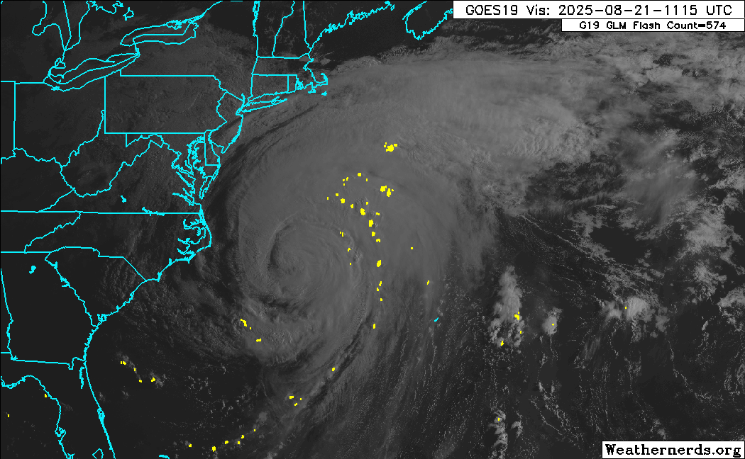
GOES-19 visible satellite loop of Erin off the coast of North Carolina. The hurricane is beginning to lose its tropical characteristics and has become asymmetric, with most of its convection located north and east of the center. (Weathernerds)
Trend:
Gradual weakening is forecast during the next couple of days, and Erin will likely become a post-tropical cyclone on Saturday.
Watches and warnings:
Tropical storm warning: Beaufort Inlet, NC to Chincoteague, VA including Albemarle and Pamlico Sounds
Storm surge warning: Cape Lookout to Duck, NC
Tropical storm watch: Bermuda
Hazards affecting land:

NWS coastal flood risk map for southeastern Virginia today, showing major coastal flooding risks for the lower James River and the Atlantic coasts of Virginia Beach and the Eastern Shore.
Although Erin is moving away from the coast, it is expected to continue generating extremely dangerous and life-threatening conditions along the Atlantic coasts of Virginia and the Outer Banks today and tomorrow. There is a high risk for major coastal flooding along the Atlantic coasts of the Outer Banks, Virginia Beach, and Eastern Shore, as well as the lower James River near Fort Eustis, Newport News, and Smithfield today. While the risk will be lower tomorrow, there is still a moderate risk for these same areas.
Extremely heavy surf and life-threatening rip currents will likely persist through the weekend. Although Erin will be long gone by Saturday and Sunday, conditions at the beaches will remain extremely hazardous and venturing into the ocean is strongly not recommended.

NWS wind risk map for southeastern Virginia, showing a moderate risk of severe winds along the Norfolk and Virginia Beach coasts as well as the lower Eastern Shore.
Erin is currently producing tropical storm conditions along the Outer Banks and the Virginia Beach Oceanfront. A weather station at Jennette’s Pier in Nags Head, NC recently reported a sustained wind of 44 mph and a gust to 52 mph, despite the center of Erin being located nearly 300 miles offshore. These winds will persist through tonight before subsiding. Further inland, although tropical storm conditions are not expected, sustained winds of 15 to 25 mph with higher gusts are possible as far inland as the I-95 corridor near Richmond and Petersburg.
Focus on Central Virginia:
Erin is still not forecast to produce any direct effects inland over Central Virginia. Although the area is mostly dominated by low clouds and drizzle, these are associated with a frontal boundary that is slowly pushing through the region - this front is also what is steering Erin out to sea. The front will move through by late this evening, allowing for clearing skies and bringing with it some cooler air and lower humidity. However, gusty winds are still possible along and east of I-95 due to Erin, but we’re talking winds of about 15 to 25 mph sustained with gusts up to 35 mph. Strong, but not particularly damaging. The winds will subside tonight as the front pushes through and Erin moves away.
The beaches will remain a dangerous place through the weekend, even after Erin moves away. Extremely dangerous conditions will persist along the Virginia beaches and Outer Banks for the next several days as the massive waves generated by Erin will take some time to die down. Very heavy surf with high waves will continue to cause coastal flooding, and there will be a high risk of life-threatening rip currents at least through Monday. Many coastal roads, including the 4-wheel drive portion of Corolla and Carova Beach, as well as Route 12 on Hatteras Island, are currently impassable and could remain so for several days. It remains to be seen just how much damage has been done to these roads and how long it might take to repair them.

NWS forecast temperatures for southeastern Virginia for Friday 8/22. Highs generally in the low 80s.
Once Erin is gone and the frontal system pushes through, it will be a very pleasant weekend. Friday will be the best day weather-wise with highs in the lower 80s and lows in the lower 60s with very low humidity (dew points in the low 60s!). Saturday and Sunday will be a bit warmer but the humidity will remain quite low.
On Sunday night and Monday, a relatively dry cold front will push through the area, creating a slight increase in humidity and a slight chance for some rain showers. After Monday, though, it’s going to feel like fall came early - next week most of the region will see sunny skies with highs in the upper 70s and lows in the upper 50s!
Here’s a summary of the weather in the Richmond area for the next few days:
Day | High Temp | Low Temp | Conditions |
|---|---|---|---|
Thurs 8/21 | 77° | 65° | Clouds/drizzle through evening, clearing after sunset. Winds 15-25 mph |
Fri 8/22 | 82° | 61° | Sunny and pleasant |
Sat 8/23 | 84° | 63° | Sunny and pleasant |
Sun 8/24 | 84° | 65° | Sunny through early PM, increasing clouds late, chance of showers |
Mon 8/25 | 86° | 68° | Cloudy with showers AM, clearing by noon |
Tues 8/26 | 77° | 58° | Sunny and fall-like! |
Wed 8/27 | 75° | 57° | Sunny and fall-like! |
The next update on Erin will be posted tomorrow (August 22). For additional information, refer to products from your local weather office or the National Hurricane Center at http://www.hurricanes.gov.
One last thing…
Do you like what you see? Please consider sending a tip via Ko-fi! I wear a lot of hats between a day job, being a photographer, and being a worldwide weather enthusiast, and while I will never put any of my content behind a paywall (paywalls kind of defeat the purpose of this blog/newsletter/thingy), your tips definitely help! You can send a tip via the following link: https://ko-fi.com/willweaverrva