- Will Weaver's Weather & Pacific Typhoon Center
- Posts
- Focus on Central Virginia - Week of 9/15/25
Focus on Central Virginia - Week of 9/15/25
The next couple of days will be wet as a low pressure area meanders off the coast and brings some rain and gusty winds to the region, but the end of the week will make up for it.
Will Weaver
September 15, 2025
Weather Headlines for Central Virginia:
Cloudy and Dreary Start — A weak area of low pressure is meandering off the coast of the OBX, and will move northwestward into the area tonight and tomorrow. This will lead to increasing cloudiness this afternoon and high rain chances tonight, tomorrow, and Wednesday before the low weakens and moves out of the area. This rain is much needed as a good chunk of the state is approaching drought status.
Quiet and Sunny Finish — Once the low moves out, high pressure will build into the area, resulting in mostly sunny skies and low rain chances between Thursday and Sunday. Friday will be a bit on the warm side, though, and modest humidity could lead to heat index values in the mid to upper 90s.
This is the Peak? — This is the peak of the Atlantic hurricane season but there’s not much out there. Invest 92L has been designated for a low pressure area in the central Atlantic, but it appears unlikely to be a threat to any land areas.
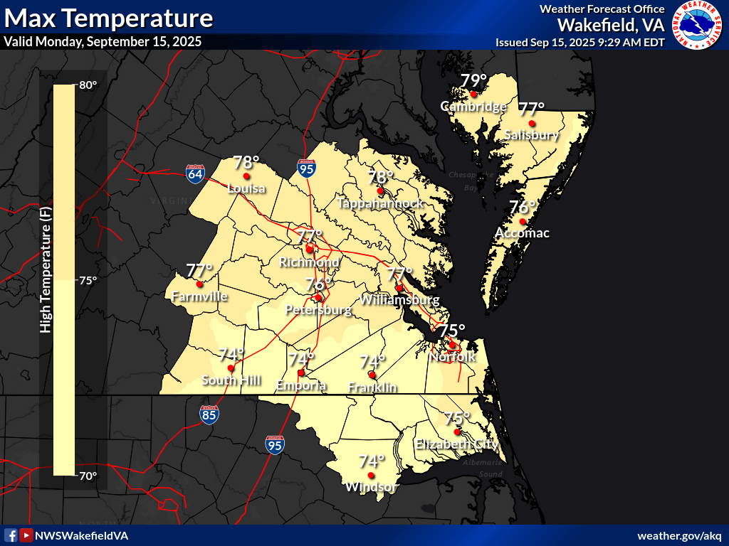
National Weather Service high temperature forecast for Monday 9/15. Highs generally in the mid to upper 70s.
In Depth:
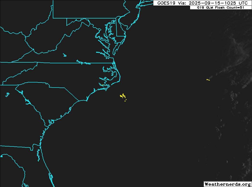
GOES-19 visible satellite loop of a weak low pressure area southeast of Cape Hatteras. (Weathernerds)
We were spoiled by the absolutely gorgeous weather we had late last week and over the weekend (despite the surprise heavy rainfall midweek), because today through Wednesday look to be quite dreary and wet. A weak area of low pressure currently meandering in the Atlantic just east of the Outer Banks is producing some cloudiness and showers at the beaches and will also contribute to heavy surf and life-threatening rip currents through midweek. This low will move northwestward later today, bringing those clouds and showers inland over eastern Virginia and North Carolina. The low is expected to more or less sit over the area through tomorrow evening. As a result, you can expect increasing clouds today with showers beginning southeast of Richmond late tonight and closer to Richmond early tomorrow.
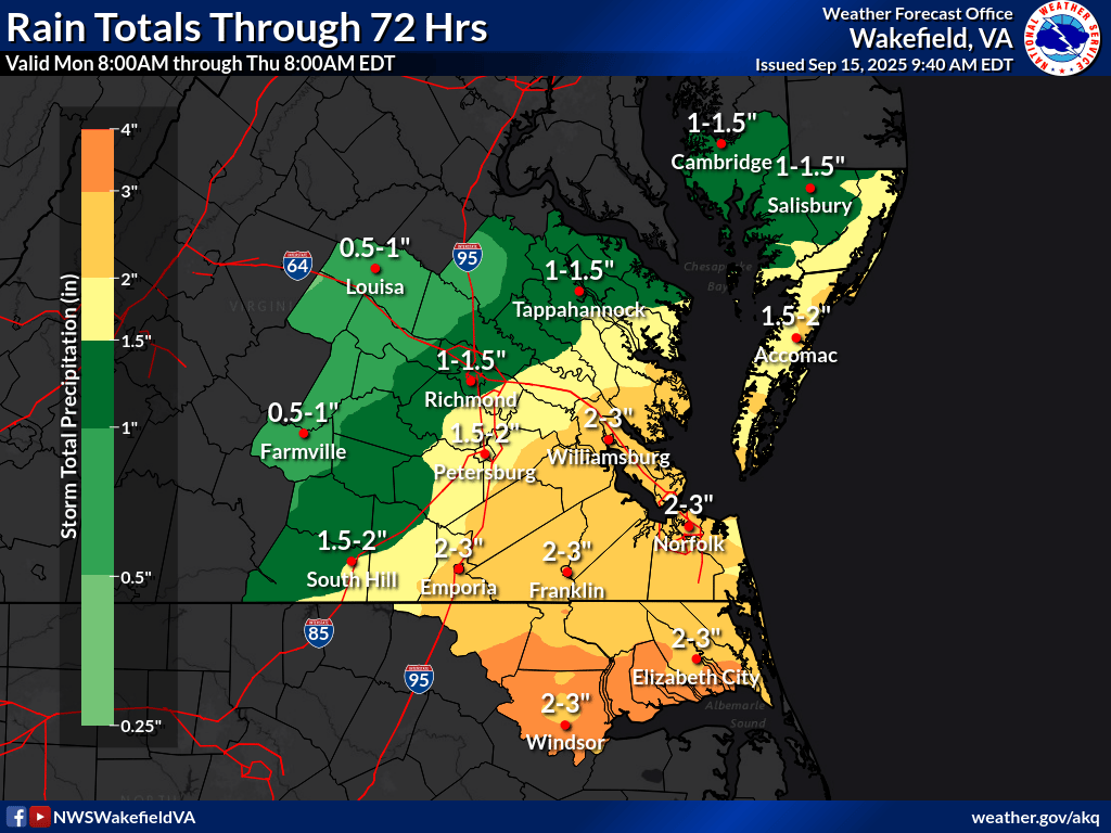
NWS rainfall forecast for southeastern Virginia and northeastern North Carolina through Thursday 9/18. Much of southeastern Virginia could see 2 to 3 inches of rain total, with 1 to 1.5 inches closer to Richmond. Parts of northeastern North Carolina could approach 4 inches.
The rain will persist on Tuesday and Wednesday. The cloud cover and rain will keep temperatures low, and in fact most of the area will struggle to make it out of the 60s on both days. The rain could be heavy at times, and by the time the rain ends on Wednesday evening, much of the area could have a total of 1 to 2 inches of rain, with higher amounts well to the southeast of Richmond. Also, although this low should not become anything tropical, it will bring gusty winds to the area and the Richmond area could see wind gusts up to 30 mph through Wednesday evening. Wind gusts could be higher at the coast. The good news, though, is this rain will be quite beneficial as a good deal of the state is either abnormally dry or in moderate drought conditions:
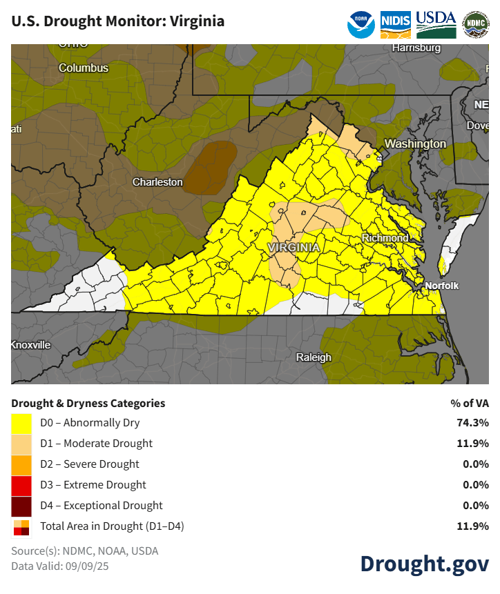
U.S. Drought Monitor for Virginia as of 9/9. Most of the state is in D0 “abnormally dry” conditions, while parts of the Piedmont and Northern Virginia are in D1 “moderate drought” conditions. The rainfall this week will provide a bit of relief.
The low should weaken and move out of the area late Wednesday night, allowing for clearing skies on Thursday as high pressure briefly moves in. A cold front will approach from the north on Friday, leading to increased humidity and warmer temperatures. In fact, it is possible we could hit 90° on Friday, and heat index values could reach the mid-90s. The front will move through the area Friday evening and cool us off for the weekend with partly to mostly sunny skies.
Here’s a summary of this week’s weather for the Richmond area:
Day | High Temp | Low Temp | Conditions |
|---|---|---|---|
Monday 9/15 | 74° | 61° | Increasing clouds, showers after sunset |
Tuesday 9/16 | 68° | 62° | Cloudy, breezy, rainy |
Wednesday 9/17 | 70° | 62° | Cloudy, breezy, rainy |
Thursday 9/18 | 78° | 61° | Gradual clearing |
Friday 9/19 | 87° | 62° | Mostly sunny, much warmer, heat index 93-95° |
Saturday 9/20 | 78° | 60° | Mostly sunny, less humid |
Sunday 9/21 | 76° | 58° | Partly sunny, increasing clouds PM |
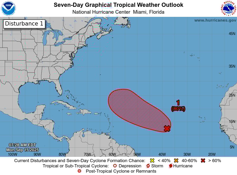
NHC tropical weather outlook, showing only one disturbance with development potential in the Central Atlantic
Despite this part of the month being the usual “peak” of the Atlantic hurricane season, the tropics remain mostly quiet. There is a disturbance being monitored in the central Atlantic that the NHC has designated Invest 92L, and it will very likely become the next named storm sometime this week, but all indications are that it won’t be a direct threat to any land areas.
One last thing…
Do you like what you see? Please consider sending a tip via Ko-fi! I wear a lot of hats between a day job, being a photographer, and being a worldwide weather enthusiast, and while I will never put any of my content behind a paywall (paywalls kind of defeat the purpose of this blog/newsletter/thingy), your tips definitely help! You can send a tip via the following link: https://ko-fi.com/willweaverrva