- Will Weaver's Weather & Pacific Typhoon Center
- Posts
- Focus on Central Virginia - 8/5 through 8/10/25
Focus on Central Virginia - 8/5 through 8/10/25
Dreary and drizzly for the next couple of days, but below normal temperatures continue. Some minor tropical trouble could be on tap for this weekend, though.
Will Weaver
August 05, 2025
Weather Headlines for Central Virginia:
Below Normal Temps — Temperatures are going to remain unseasonably mild for the next few days as high pressure continues to be entrenched over the area. This high is expected to begin to push off to the northeast, but temps will be in the low 80s for most of the rest of the week.
Increasing Rain Chances & Humidity — As the high moves off to the northeast, easterly wind flow will cause more moist air to funnel into the area, which will increase humidity and rain chances. Today is pretty much the last day of relatively low humidity we’ll have for the rest of the week, although dew points will likely remain in the low 70s for the rest of the week, which isn’t nearly as stifling as the humidity we dealt with before last week.
Tropical Trouble? — The National Hurricane Center is monitoring a tropical disturbance off the Southeastern U.S. coast, which has a medium (40%) chance of becoming a tropical depression by this weekend. This system will likely be quite weak, but it will nonetheless increase rain chances this weekend.
Pay No Attention to the Hurricane Behind the Curtain — Long-range models, particularly the GFS model, show a hurricane affecting the region in a couple of weeks. This is a reminder that the models do not have much skill beyond 10 days, so this scenario appears to be quite unlikely. I’ll explain more later.
In Depth:

High temperatures for Tuesday 8/5. Temperatures will struggle to reach 80 degrees across much of Central Virginia today. (NWS)
High pressure continues to be entrenched over the area, although you wouldn’t know it looking outside. It’s been cloudy and drizzly today and this will continue for the next couple of days as winds shift from north to northeast to east. Although the clouds will keep temperatures unseasonably mild - temperatures in the upper 70s today and tomorrow, and in the low 80s on Thursday - those easterly winds will bring increased moisture from offshore, hence our dreary and sprinkly weather. Humidity will also be slightly higher, but not oppressive like earlier this summer.

High temperatures for Wednesday 8/6. Basically the same as today, but maybe a bit warmer east of I-95. (NWS)

High temperatures for Thursday 8/7. Temperatures finally break 80 degrees, and the rain should come to an end. (NWS)
Things should change on Thursday as the moisture begins to retreat to the south of the area. The skies should clear out on Thursday afternoon, but temperatures will still be below normal with highs in the low 80s. Humidity will remain somewhat high but again, not stifling, with dew points around 70°.
Friday looks like it will be fairly pleasant. Sunny skies, temperatures in the low 80s, and relatively low humidity (dew points in the mid to upper 60s). This is due to a developing tropical disturbance off the Southeastern U.S., which will filter in cooler and drier air from the northeast as its circulation spins up.

National Hurricane Center tropical weather outlook, focusing on a disturbance off the Carolina coastline with a 40% chance of formation during the next 7 days
That tropical disturbance I mentioned is being monitored by the National Hurricane Center for possible development, and NHC has assigned it a medium (40%) chance of formation during the next 7 days. The models are not particularly impressed with this system or its development chances, and any tropical cyclone that does form will likely be very weak and short-lived. It will probably also not have any direct impacts on central Virginia, although it could increase rip current risks at the beaches from Friday through Sunday. The disturbance will also bring more tropical moisture into the region, and that will result in warmer temperatures and much higher humidity. Expect high temps to be in the mid to upper 80s between Friday and Sunday.
Here’s a summary of this week’s weather for the Richmond area:
Day | High Temp | Low Temp | Conditions |
|---|---|---|---|
Tuesday 8/5 | 77° | 62° | Cloudy with scattered showers |
Wednesday 8/6 | 77° | 65° | Cloudy with scattered showers |
Thursday 8/7 | 81° | 66° | Cloudy with scattered showers, clearing late afternoon |
Friday 8/8 | 82° | 65° | Mostly sunny, low(ish) humidity |
Saturday 8/9 | 84° | 68° | Partly sunny, PM storms, more humid |
Sunday 8/10 | 88° | 70° | Partly sunny, PM showers/storms |

National Hurricane Center tropical weather outlook focused on a tropical disturbance in the eastern Atlantic that has a 50% chance of development in the central Atlantic during the next 7 days
Finally, to address the elephant in the room. Model guidance shows a tropical system forming in the central Atlantic over the weekend, and the National Hurricane Center indicates a medium (50%) chance of tropical cyclone formation during the next 7 days. Some long-range model guidance shows a strong hurricane approaching the mid-Atlantic in a couple of weeks, and a few really loud hypemongers have latched onto this and are spreading a great deal of misinformation.
The GFS model is an okay weather model, but its forecasting skill drops like a rock after 10 days (240 hours). Unfortunately for all of us, it goes out to 16 days (384 hours). The latest run of the GFS has a powerful hurricane over eastern Virginia at 282 hours. This should be taken with the tiniest, eensy-weensiest grain of salt because of the GFS’s low skill at that point in its forecast. To demonstrate it even more, here is an animation of the same point in time in the last 5 runs of the GFS:
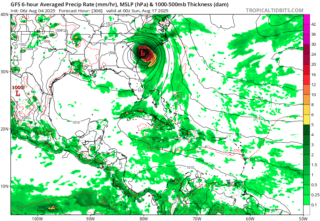
Animated GIF of the last 5 runs of the GFS, showing conditions at 0000 UTC (8:00pm EDT) Sunday 8/17. They all depict the same system at five wildly different locations, with the 00Z 8/5 run of the GFS not showing the system at all…because it’s over the north central Atlantic. (Tropical Tidbits)
This is definitely not what I would call a consistent trend. Long-range models are useful if a trend seems to be developing, but right now there isn’t one, so at this point it’s waaaaaaay too early to be talking about it. If anyone is shouting “there’s a big hurricane coming, we’re all going to die” from the rooftops, you should ignore them.
One last thing…
Do you like what you see? Please consider sending a tip via Ko-fi! I wear a lot of hats between a day job, being a photographer, and being a worldwide weather enthusiast, and while I will never put any of my content behind a paywall (paywalls kind of defeat the purpose of this blog/newsletter/thingy), your tips definitely help! You can send a tip via the following link: https://ko-fi.com/willweaverrva