- Will Weaver's Weather & Pacific Typhoon Center
- Posts
- Focus on Central Virginia - 7/29 through 8/3/25
Focus on Central Virginia - 7/29 through 8/3/25
C-C-C-C-Changes coming this week, with a big cooldown that will last longer than a day! But we've got to get through some more extreme heat first.
Will Weaver
July 28, 2025
Weather Headlines for Central Virginia:
Hot, Hot, Hot — More of the same for the first part of the week, with hot and humid conditions prevailing. A heat advisory is in effect today, and there will likely be a heat advisory issued on Wednesday as high temps will be in the mid to upper 90s, sending heat index values well over 100°. Wednesday will be the worst day of the week with highs pushing 100° and heat index values as high as 108°.
C-C-Changes — BIG pattern change happens later this week as a strong cold front moves through the mid-Atlantic region. MUCH cooler temperatures and higher rain chances on Thursday and Friday, followed by MUCH lower humidity for the weekend. This weekend looks absolutely gorgeous.
In Depth:
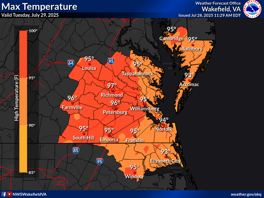
Tuesday’s high temperatures. Mid to upper 90s for everybody! (National Weather Service)
You’re probably well aware of this already but it’s still hot. And sadly, it’s going to continue to be hot for another couple of days as this stubborn heat dome remains in place. Today we’re seeing temperatures in the low 90s with heat index values well over 100°, and Tuesday will be more of the same with even higher high temperatures. The good news is the humidity won’t be quite as high tomorrow, so heat index values will probably not reach heat advisory criteria. Also, unlike this weekend which saw severe thunderstorms across most of central Virginia, rain chances should remain low.
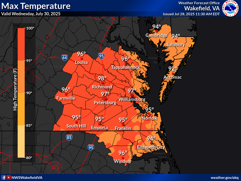
Wednesday’s high temperatures. Guess what, more extreme heat, go figure. (National Weather Service)
The good news is that Wednesday should be the last day of extreme heat we see for a while. The bad news is…well, we still have to deal with the extreme heat. Even worse, the humidity will be higher again, so we’re probably looking at heat advisory criteria again: high temperatures in the upper 90s and heat index values of 105 to 108°. There will also be an increased chance of showers and thunderstorms on Wednesday evening, and of course, any thunderstorms that form will likely produce very heavy rainfall.
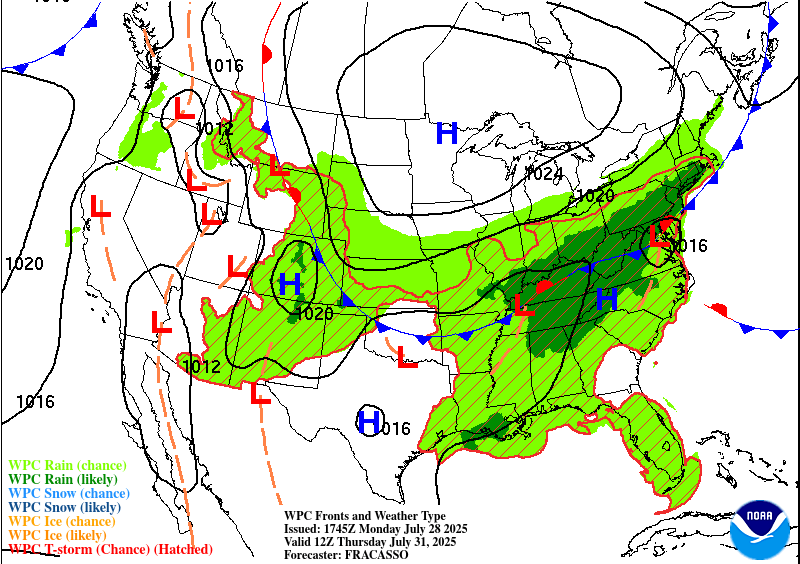
Weather map with fronts for Thursday 7/31. Most of the eastern US is looking quite wet as a cold front finally pushes through, with an area of low pressure over the mid-Atlantic (Weather Prediction Center)
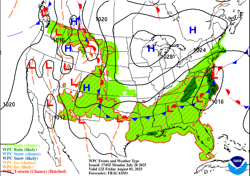
Weather map with fronts for Friday 8/1. The front has pushed through but the area is still quite rainy thanks to that low pressure area lurking just off the Delmarva (Weather Prediction Center)
The pattern finally breaks — and when I say I break, I mean for longer than like two days — on Thursday. It will still be fairly warm with highs around 90°, but clouds will roll in early Thursday afternoon and bring high rain chances. Nothing torrential, but much of the region could see about 0.5 to 1 inch of rainfall. Most importantly, the cloud cover will bring temperatures down, and temperatures will likely fall into the 80s during the afternoon. Friday will be mostly the same (cloudy and rainy), except high temperatures will struggle to make it too much higher than 80°.
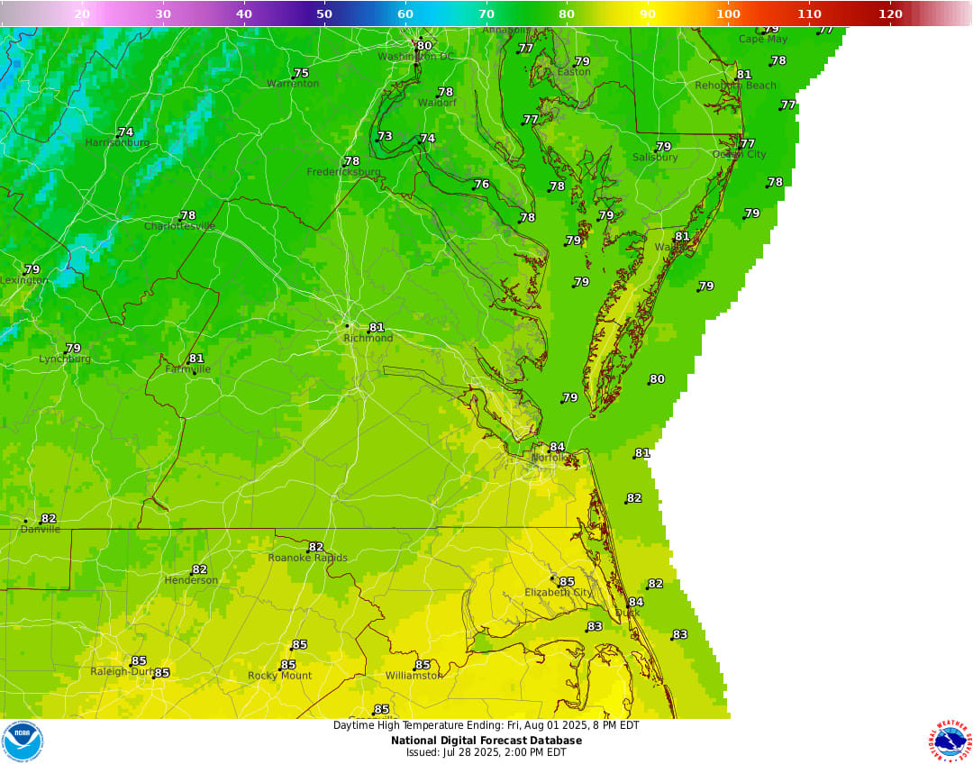
Saturday’s high temperatures. Upper 70s to lower 80s? With low humidity? In AUGUST?! Yes, PLEASE! (National Weather Service)
This weekend looks to be absolutely spectacular in terms of weather as the rain moves out late Friday night. Saturday and Sunday look to be very pleasant with sunny skies and unseasonably cool temperatures: much of the Richmond area north of I-64 might not even reach 80 degrees on Saturday, and lows could be in the upper 50s across much of the area. Sunday looks much the same: high temperatures around 80 degrees, even lower humidity (dew points in the lower 60s), and lows in the lower 60s. If you’re planning to do anything this weekend, the weather should be downright perfect. Here’s a summary of this week’s weather for Richmond:
Day | High Temp | Low Temp | Conditions |
|---|---|---|---|
Tuesday 7/29 | 95° | 76° | Sunny, hot, humid, heat index 100-103° |
Wednesday 7/30 | 98° | 75° | Sunny, hot, humid, heat index 105-108° |
Thursday 7/31 | 90° (falling into 80s PM) | 72° | Cloudy, PM showers and storms |
Friday 8/1 | 81° | 68° | Cloudy, showers through sunset |
Saturday 8/2 | 80° | 61° | Mostly sunny and pleasant! |
Sunday 8/3 | 82° | 64° | Mostly sunny and pleasant! |
One last thing…
Do you like what you see? Please consider sending a tip via Ko-fi! I wear a lot of hats between a day job, being a photographer, and being a worldwide weather enthusiast, and while I will never put any of my content behind a paywall (paywalls kind of defeat the purpose of this blog/newsletter/thingy), your tips definitely help! You can send a tip via the following link: https://ko-fi.com/willweaverrva