- Will Weaver's Weather & Pacific Typhoon Center
- Posts
- Focus on Central Virginia - 7/21 through 7/25/25
Focus on Central Virginia - 7/21 through 7/25/25
A brief reprieve from the heat and humidity, then back to the old grind late in the week
Will Weaver
July 21, 2025
Weather Headlines for Central Virginia:
Delayed Relief — A cold front is currently pushing through central Virginia, but it’s taking its time. This means one more day of cloudy, warm, and humid weather with a chance of heavy rain this evening. Closer to the beaches, it will be straight up hot with temperatures in the low 90s.
A Much Needed Break — Once the front moves through, the humidity will drop quite a bit. Dew points should drop into the mid-60s, which is technically still humid but will feel quite comfortable compared to the past couple of weeks! This drier air will stick around through Thursday, and the next couple of days will be quite pleasant with sunny skies and high temperatures in the mid-80s. Thursday will be a bit hotter with temperatures around 90.
Return of the Heat — This reprieve will not last long. By Thursday evening the humidity will be back on the rise, and Friday and Saturday will be very hot and humid with high temperatures soaring back into the mid-90s. Heat index values could approach 105°, and heat advisories could be needed for parts of the area. Enjoy the nice weather while you can!
In Depth:
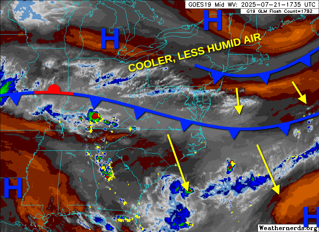
Trust me, the cooler and less humid air is coming! Surface analysis drawn on a GOES-19 water vapor satellite image from Weathernerds.
So, it was supposed to be cooler and less humid today, but that didn’t actually pan out. It’s noticeably humid and very dreary, with scattered showers. The cold front is moving through, but it’s moving a bit more slowly than anticipated. As a result, today is warm, humid, and cloudy. The front is almost through the area, though, and a second reinforcing cold front will push south later this afternoon, so you can expect a noticeable drop in the humidity later this evening.
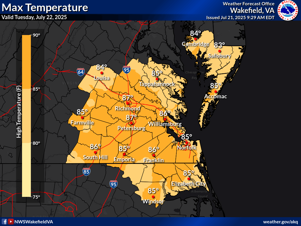
Temperatures across southeastern Virginia will be in the mid 80s for the most part on Tuesday, with much lower humidity!
Tomorrow and Wednesday look to be very, very pleasant compared to basically the entirety of July so far. Humidity will be much lower with dew points in the low to mid 60s, which is technically still considered humid but will feel quite refreshing compared to the near-constant dew points in the upper 70s. It will be mostly sunny both days with highs in the mid 80s and lows in the upper 60s. If there’s anything you want to do outdoors, those are going to be your best opportunities to do it! It’ll be in the lower 80s near the beaches with a nice onshore breeze, so might I suggest a daytrip to Virginia Beach?
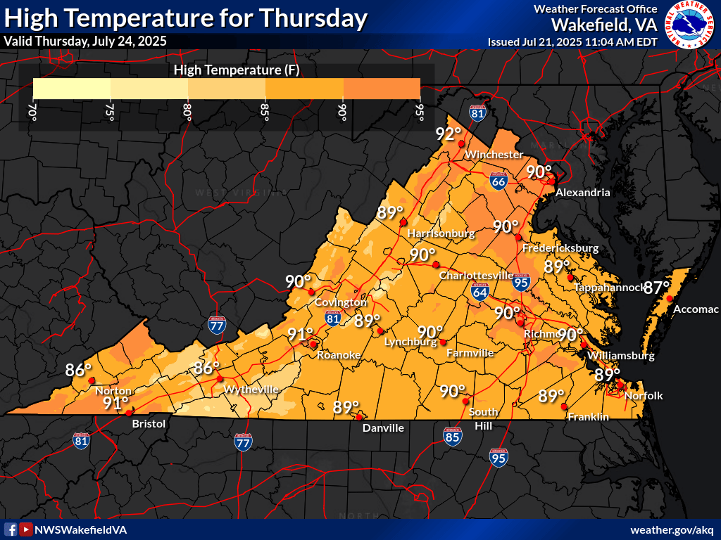
High temperatures for Virginia on Thursday. Slightly warmer than tomorrow and Tuesday with temperatures in the upper 80s to around 90.
Thursday will be noticeably warmer and slightly more humid with temperatures in the upper 80s to around 90 across much of central and eastern Virginia. Still, it won’t feel too bad, and the skies will be sunny with minimal rain chances. The humidity will be back with a vengeance on Thursday night, though, as a warm front pushes northward and dissipates over the region, leaving behind much warmer and more humid air.
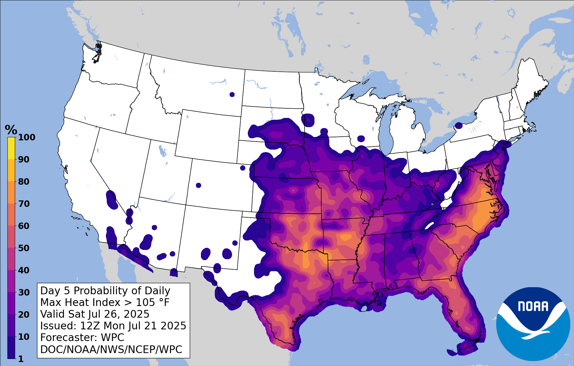
Probability of a heat index above 105°F on Saturday. Yeah, that’s southeastern Virginia in the 80 to 90% range. Saturday is not going to be very fun.
The heat and humidity come back with a vengeance on Friday and Saturday, and Saturday will be by far the worse of the two days. A long-term heat wave building in the south central U.S. will finally make its way eastward, and Friday and Saturday look to be sweltering with highs in the mid to upper 90s. The humid air left behind by that dissipating front will send heat index values soaring well above 100°, and in fact, the Weather Prediction Center indicates a 55% chance of a max heat index above 105° on Friday and a 71% chance on Saturday. A heat index above 105° usually warrants a heat advisory. Saturday could be even worse, with a nearly 50-50 chance of a heat index above 110°, which would usually warrant an extreme heat warning. Needless to say, these won’t be great days for outdoor activity, but if you must be outdoors, stay hydrated and watch for signs of heat-related illness!
Although long-range forecasts tend to have low skill, early indications are that the heat will continue over the weekend into next week, with increasing chances for rain beginning on Sunday. So yeah, enjoy this week while you can!