- Will Weaver's Weather & Pacific Typhoon Center
- Posts
- Focus on Central Virginia - 7/14 through 7/18/25
Focus on Central Virginia - 7/14 through 7/18/25
The unsettled and rainy pattern continues this week across much of the region, but it won't be quite as hot
Will Weaver
July 14, 2025
Weather Headlines for Central Virginia:
Rain, Rain, Rain — The unsettled and rainy pattern we’ve had for the past week or so is going to stick around this week. Very warm temperatures and very humid air will lead to chances of thunderstorms basically every day of the week, and any thunderstorms will be likely to cause heavy rainfall and frequent lightning.
Not quite as hot — Temperatures will not be quite as hot as they’ve been, mainly due to cloud cover over much of the region. Still, the very humid air will make it feel very miserable, and heat index values will be pushing 100° basically every day.
Tropical disturbance in the Gulf not a concern — A tropical disturbance located off the coast of Florida (Invest 93L) has a 30% chance of developing into a tropical cyclone this week, but it should not bring any effects to Central Virginia.
In Depth:
You’re not imagining things, it really has been an extremely wet July. Most of the region has seen two to three months’ worth of rain this month, and we’re not even halfway through it yet! Here’s a table of normal monthly rainfall and what’s been observed so far:
Location | Normal monthly rainfall | Rainfall through July 14 |
|---|---|---|
Richmond | 4.37” | 9.21” |
Farmville | 4.02” | 7.01” |
Wakefield | 5.47” | 5.01” |
Ashland | 4.29” | 3.59” |
Charlottesville | 3.37” | 3.40” |
South Boston | 4.01” | 6.08” |
Emporia | 5.02” | 4.86” |

NWS rainfall forecast for the next 3 days for the Richmond area, showing 1 to 2 more inches of rain through Thursday

Lightning risk for today
Unfortunately you can expect more of the same. The soupy air mass is still in place, and as a result, any showers and thunderstorms that develop will likely be slow moving and will produce heavy rainfall. This, in turn, will bring chances of more flash flooding, which has already been a concern during the past few days with numerous water rescues and road closures throughout the Richmond metro area. The best chances of heavy rainfall will be in the Richmond area and points to the north and west. Also, any thunderstorms that develop will cause frequent lightning…again…and this could cause scattered power outages. Although there is a marginal risk of severe weather today, severe thunderstorms are unlikely.

Weather Prediction Center excessive rainfall outlook for Monday, July 14th
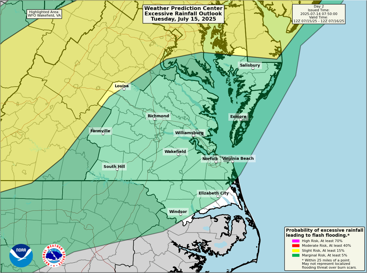
Weather Prediction Center excessive rainfall outlook for Tuesday, July 15th
The Weather Prediction Center has a Slight Risk (level 2) of excessive rainfall across much of the region today, with the best chances of heavy rainfall happening between 6pm and 10pm. Parts of the DC Metro Area are under a Moderate Risk (level 3), and flash flooding is much more likely in that part of the state. There is a Marginal Risk (level 1) for the Richmond metro area tomorrow.
Thanks in part to the cloudy and dreary weather, it won’t be quite as hot as it’s been. However, it will still feel pretty miserable, with high temperatures around 90° and heat index values approaching 100° pretty much every day this week. Make sure to stay hydrated and monitor for signs of heat-related illness if you need to be outdoors.

National Hurricane Center 7-day tropical weather outlook showing an area of interest off the Florida coast
Finally, the National Hurricane Center is monitoring a tropical disturbance (Invest 93L) off the eastern coast of Florida. This disturbance is expected to move westward across Florida and into the Gulf of Mexico during the next couple of days. This system has a low - 30% - chance of development into a tropical cyclone as it crosses the Gulf this week. This system is not expected to bring any direct effects to Central Virginia, although it will probably bring a ton of rain to parts of the South that really, really don’t need it.