- Will Weaver's Weather & Pacific Typhoon Center
- Posts
- Focus on Central Virginia 10/23/25 through 10/29/25: Cool, dry, and a little frosty
Focus on Central Virginia 10/23/25 through 10/29/25: Cool, dry, and a little frosty
The next few days look to be fairly quiet, with below normal temperatures and some chilly - maybe even frosty - nights. Rain chances return early next week as a frontal system approaches.
Will Weaver
October 23, 2025
Weather Headlines for Central Virginia:
Stay Frosty, Richmond — The next few days look to be more or less the same as the last few days. Pleasant weather and sunny skies with fairly cool temperatures. However, the nights will be pretty cold for this time of year, with low temperatures falling into the upper 30s along and west of I-95 tonight, Friday night, and Saturday night. This could result in some widespread frost - freezing temperatures are even possible in portions of the eastern Piedmont tonight and tomorrow night!
Much Needed Rain — Clouds will roll into the area late this weekend as a frontal system approaches. This system will bring some increased rain chances to much of the area on Monday, Tuesday, and Wednesday. Any rain we get will certainly be welcome as much of Virginia is currently in a state of drought, with some patches of severe drought in the Shenandoah Valley.
Missing Melissa — Tropical Storm Melissa is currently churning in the Caribbean Sea, and it is forecast to become a formidable hurricane by the middle of next week. Melissa isn’t expected to be a threat to this area, thankfully.
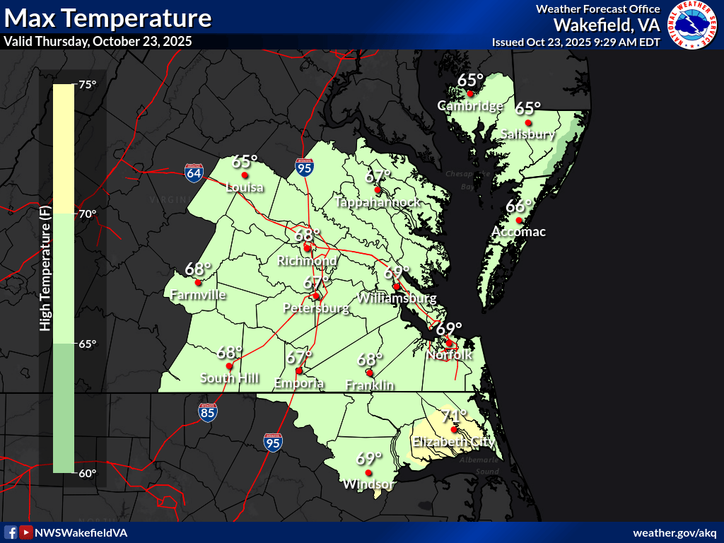
National Weather Service high temperature forecast for Thursday 10/23. Highs generally in the mid to upper 60s.
In Depth:
There really isn’t a whole lot to say about the weather for the rest of the week. Although a dry cold front will move through today and result in some breezy conditions this afternoon, high pressure should dominate the region through Saturday. Expect high temperatures today to be in the mid to upper 60s, with slightly warmer temperatures in the Hampton Roads region. Skies should be mostly sunny, though there could be a few clouds here and there this afternoon as the front passes.
The breezy conditions combined with very low humidity will result in an increased fire danger across the region today. Don’t burn anything, because brush fires could spread very rapidly.
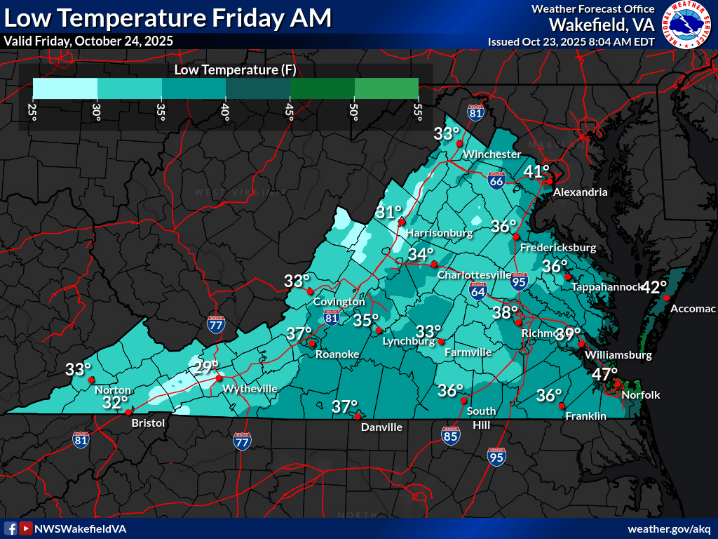
National Weather Service low temperature forecast for Friday 10/24. Low temperatures in the mid to upper 30s in the Richmond area, close to freezing in the Farmville area, and much warmer in Hampton Roads and the Eastern Shore.
I take back what I said about there not being much to talk about, because tonight and early tomorrow morning will be COLD - possibly the coldest night of the season so far. Expect temperatures in the Richmond area (along I-95) to be in the mid to upper 30s. Not too far west, though, portions of the Eastern Piedmont could actually approach freezing! Needless to say, widespread frost is possible, and the National Weather Service has issued frost advisories for much of that region. The first freeze of the season is also not out of the question for locations such as Goochland, Powhatan, and Farmville. You should bring in or cover sensitive vegetation and for the love of God bring in your pets to keep them safe from the cold.
Bear in mind that once a freeze is deemed to occur, it is considered the end of the growing season and no further frost advisories or freeze warnings will be issued until the spring.
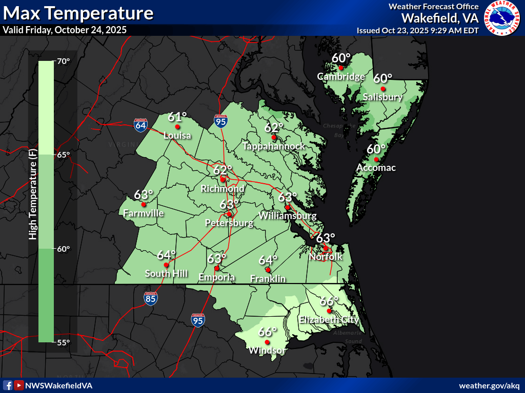
National Weather Service high temperature forecast for Friday 10/24. Highs generally in the low to mid 60s.
Tomorrow and Saturday will be much cooler than today as high pressure builds back in behind the frontal passage today. Temperatures will struggle to make it over 60 across much of the area, with some upper 50s even possible on the Eastern Shore and in the Piedmont region. Needless to say, it won’t be shorts and flip-flops weather, though it should still be fairly nice with sunny skies.
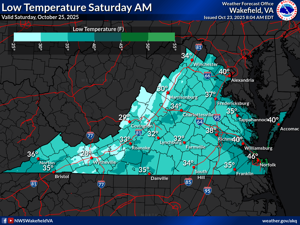
National Weather Service low temperature forecast for Saturday 10/25. Much of the Richmond area is in the low to mid 30s, with upper 30s in the City of Richmond, in Hampton Roads, and along the coast.
Friday night/Saturday morning will be even colder than tomorrow night! Temperatures will fall into the low to mid 30s across much of the region. Once again, widespread frost is likely, and I would not be surprised to see some freeze warnings closer to Richmond, including parts of western Chesterfield, Henrico, and Hanover Counties.
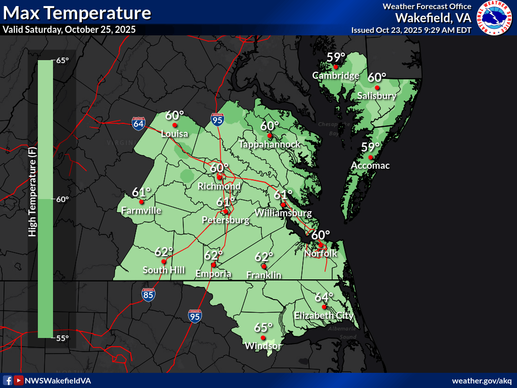
National Weather Service high temperature forecast for Saturday 10/25. Temperatures in the low 60s across the entire area, with upper 50s on the Eastern Shore.
Saturday should be similar to Friday: sunny skies, mild temperatures, and no chance of rain. Saturday night/Sunday morning will once again bring a chance of widespread frost or freezing temperatures across the western portions of the region.
Sunday will likely see increasing cloudiness as a frontal system approaches from the west. This system will bring chances of some much-needed rainfall to the region on Monday, Tuesday, and Wednesday, though cloud cover will likely keep temperatures in the upper 50s on all three days. Much of Virginia is in a state of drought, and any rain will be very, very beneficial, though it seems unlikely that we’ll get a drought-busting gully-washer from this system.
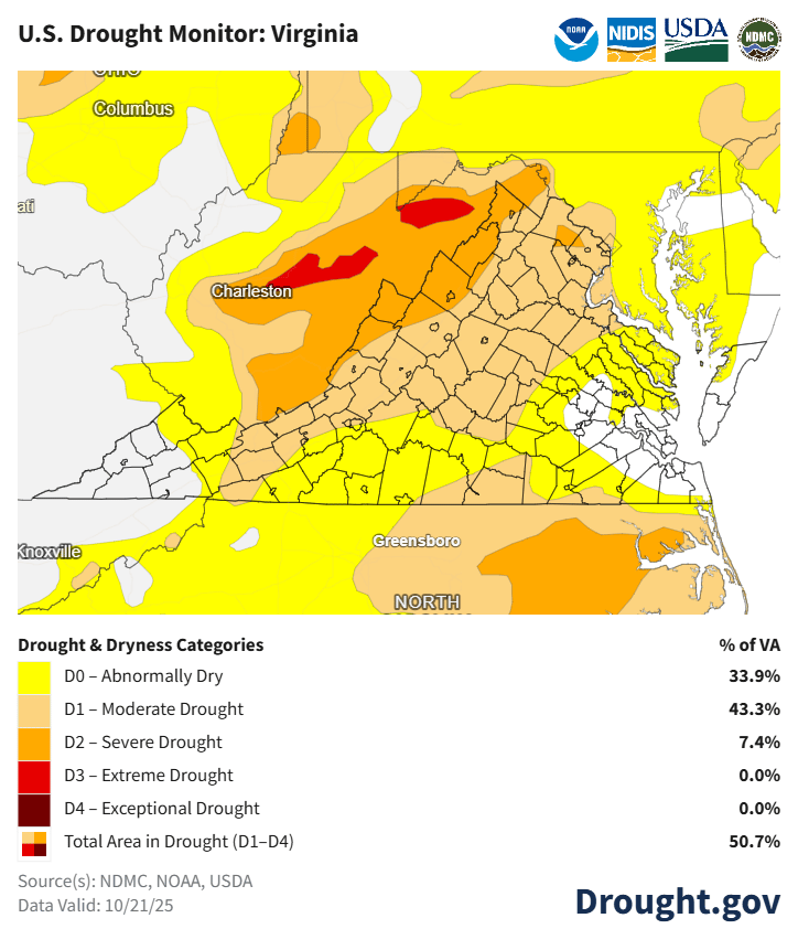
U.S. Drought Monitor from Tuesday 10/21 for the mid-Atlantic. A large portion of Virginia stretching from southwestern Virginia to the DC metro area is in a moderate drought, with some patches of severe drought. Southside and Southeastern Virginia are a bit better off but still mostly “abnormally dry”.
Here’s a summary of the week’s weather for the Richmond area:
Day | High Temp | Low Temp | Conditions |
|---|---|---|---|
Thursday 10/23 | 66° | 36° | Sunny and breezy Increased fire danger |
Friday 10/24 | 62° | 34° | AM frost, especially W of RVA; Sunny and mild |
Saturday 10/25 | 60° | 33° | AM frost; Sunny and mild |
Sunday 10/26 | 63° | 41° | Increasing clouds PM |
Monday 10/27 | 56° | 46° | Cloudy w/a chance of showers |
Tuesday 10/28 | 57° | 45° | Cloudy w/a chance of showers |
Wednesday 10/29 | 56° | 45° | Cloudy w/a chance of showers |
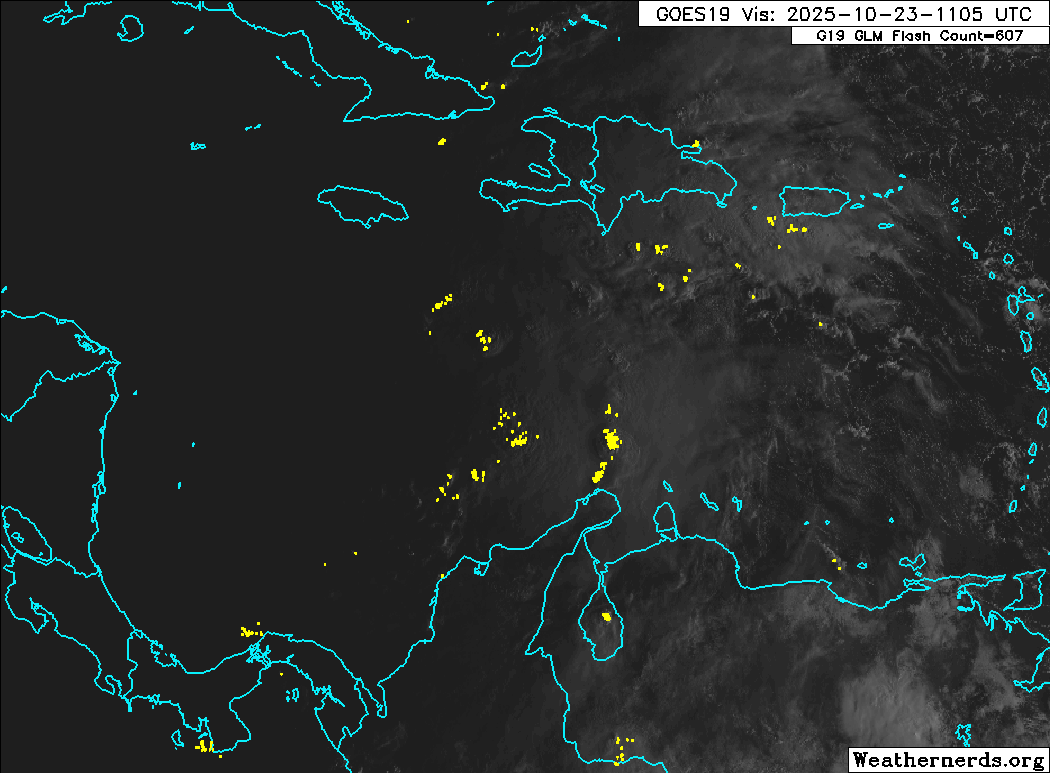
GOES-19 visible satellite loop of Tropical Storm Melissa in the central Caribbean Sea. (Weathernerds)
In the tropics, Tropical Storm Melissa is currently located in the Caribbean Sea south of Haiti. Although it’s not forecast to move very much during the next several days, it is expected to become a rather formidable hurricane by the middle of next week. Melissa is not expected to be a threat to the U.S. East Coast and will not have any impact on our weather, partially thanks to that frontal system I mentioned.
One last thing…
Do you like what you see? Please consider sending a tip via Ko-fi! I wear a lot of hats between a day job, being a photographer, and being a worldwide weather enthusiast, and while I will never put any of my content behind a paywall (paywalls kind of defeat the purpose of this blog/newsletter/thingy), your tips definitely help! You can send a tip via the following link: https://ko-fi.com/willweaverrva