- Will Weaver's Weather & Pacific Typhoon Center
- Posts
- 2025 Pacific Typhoon Season Wrap-Up
2025 Pacific Typhoon Season Wrap-Up
The 2025 Pacific typhoon season had an above normal number of storms, but a below normal amount of activity as many systems were short-lived.
Will Weaver
December 31, 2025
...2025 Pacific typhoon season near normal but loaded with relatively short-lived systems...
Updated 1/1/26 to remove Iona (01C)
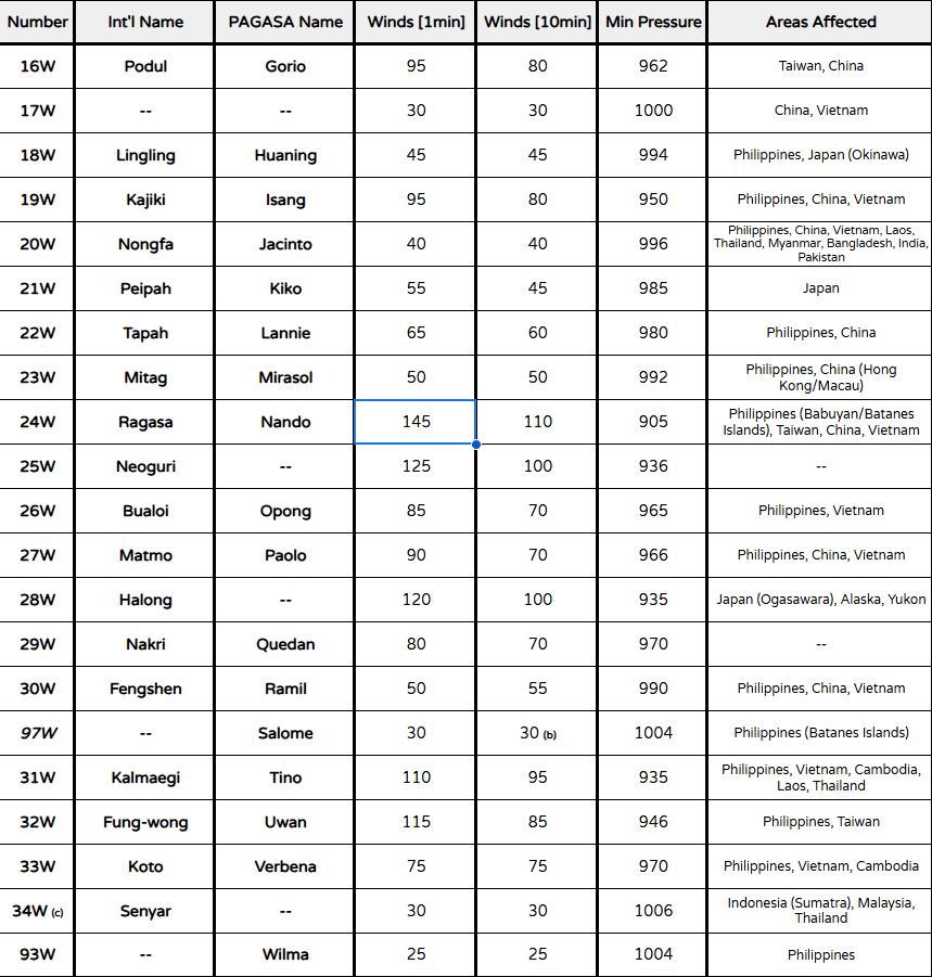
In terms of numbers of tropical cyclones, the 2025 Pacific typhoon season was slightly above normal, with 27 tropical cyclones receiving international names and 23 systems existing within the Philippine Area of Responsibility. In addition, one tropical cyclone - Senyar (04B) - unprecedentedly crossed over from the North Indian Ocean to the Western Pacific basin, although there is some debate as to whether this was a proper continuation. Overall, however, the season was below normal in terms of accumulated cyclone energy as many of the systems that developed were short-lived, especially before mid-September. Also, there was a low number of intense tropical cyclones, with 2025 featuring only one super typhoon (JTWC definition), the least in the basin since 2010.
Despite the large number of short-lived systems, the season was fairly destructive, although not nearly to the extent of the 2024 season. Western Pacific tropical cyclones affected areas as far west as Pakistan (with the remnants of Tropical Storm Nongfa surviving all the way to the Arabian Sea) and as far northeast as the Arctic coast of Alaska and the Yukon (the extratropical phase of Typhoon Halong). Overall, the season is responsible for over 720 fatalities and over US$10 billion in damage. The most intense tropical cyclone of the season was Super Typhoon Ragasa (24W/Nando), which peaked at an intensity of 145 kts (1-min) and bottomed out at a pressure of 905 hPa.
Tables of all systems tracked by this group are included below, with the following notes:
(b) Salome was operationally classified as a tropical storm by PAGASA but downgraded to a 30 kt tropical depression in post-storm analysis.
(c) Tropical Depression 34W was operationally considered a continuation of Cyclonic Storm Senyar (04B) from the North Indian Ocean basin. It is still unclear whether this system was a true continuation.
PAGASA systems Auring (94W), Fabian (96W), Salome (97W), and Wilma (93W) were not numbered by JTWC or warned on by JMA.